List of places on the Victorian Heritage Register in Alpine Shire
This is a list of places on the Victorian Heritage Register in Alpine Shire in Victoria, Australia. The Victorian Heritage Register is maintained by the Heritage Council of Victoria.
The Victorian Heritage Register, as of 2021, lists the following fifteen state-registered places within Alpine Shire:[1]
| Place name | Place # | Location | Suburb or Town | Co-ordinates | Built | Stateregistered | Photo |
|---|---|---|---|---|---|---|---|
| Bright Chinese Camp Site | H2370 | 14-20 Delany Avenue | Bright | 36.728472°S 146.965833°E | 1859 | 8 June 2017 | |
| Bright Court House and Lockup | H1921 | 1-3 Park Street | Bright | 36.731333°S 146.961333°E | 1860 | 20 August 1982 | |
| Buckland River Hydraulic Gold Sluicing Paddock | H1224 | Buckland Road | Buckland | 36.840917°S 146.842750°E | 1851 | 28 November 1996 | |
| Growlers Creek Gold Bucket Dredge Site | H1303 | Williams Road | Wandiligong | 36.782583°S 146.992000°E | 1924 | 27 March 1997 | |
| Gun Reef Gold Battery Sites | H1301 | Upper West Branch of Ovens River | Selwyn | 36.966361°S 147.031028°E | 1896 | 27 March 1997 | |
| Lyrebird Gully Hop Kiln | H0070 | Lyrebird Gully Road | Harrietville | 36.897667°S 147.055722°E | c1877 | 11 May 2006 | |
| Merriang Homestead | H0566 | 6 Merriang Homestead Road | Merriang | 36.556583°S 146.681417°E | 1863 | 14 March 1984 | |
| Monarch Gold Battery Site | H1273 | Great Alpine Road | Harrietville | 36.953611°S 147.059722°E | 1935 | 19 December 1996 | |
| Mount Buffalo Chalet | H0901 | Mount Buffalo Road | Mount Buffalo | 36.722833°S 146.819417°E | 1910 | 22 January 1992 | 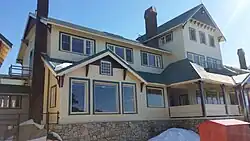 |
| Primary School No.275 | H1638 | 119 School Road | Wandiligong | 36.769222°S 146.983139°E | 1877 | 20 August 1982 | |
| Red Robin Gold Mine and Battery | H1881 | West Kiewa Logging Track and Machinery Spur Track | Hotham Heights | 36.930778°S 147.182056°E | 1860 | 20 July 2000 | |
| Rose Thistle and Shamrock Quarry Gold Mining Precinct | H1758 | Cemetery Lane | Harrietville | 36.881389°S 147.038278°E | 1860 | 26 November 1998 | |
| Sambas Gold Mine | H2356 | Great Alpine Road | Harrietville | 36.918694°S 147.052333°E | 1910 | 12 October 2017 | |
| Canyon Hydraulic Gold Sluicing Site | H1231 | Frasers Lane | Bright | 36.723194°S 146.949972°E | 1899 | 13 August 1998 | |
| Tronoh Gold Dredging Ponds | H1756 | Dredge Hole Lane and Feathertop Track | Harrietville | 36.895333°S 147.069194°E | 1942 | 26 November 1998 |
References
- "Alpine Shire". Victorian Heritage Database. Heritage Council of Victoria. Retrieved 28 November 2021.
This article is issued from Wikipedia. The text is licensed under Creative Commons - Attribution - Sharealike. Additional terms may apply for the media files.