List of places on the Victorian Heritage Register in the Shire of Baw Baw
This is a list of places on the Victorian Heritage Register in the Shire of Baw Baw in Victoria, Australia. The Victorian Heritage Register is maintained by the Heritage Council of Victoria.
The Victorian Heritage Register, as of 2021, lists the following sixteen state-registered places within the Shire of Baw Baw:[1]
| Place name | Place # | Location | Suburb or Town | Co-ordinates | Built | Stateregistered | Photo |
|---|---|---|---|---|---|---|---|
| Brunton's Bridge | H1450 | Bruntons Bridge Road | Walhalla | 37.998778°S 146.472694°E | 1887 | 20 August 1982 | |
| Former Walhalla Post Office and Residence | H0583 | Main Road | Walhalla | 37.943222°S 146.450694°E | 1885 | 29 August 1984 | |
| Lower Goodwood Kilns | H1819 | Goodwood Mill Track | Gentle Annie | 37.889111°S 145.866278°E | 1931 | 17 June 1999 | |
| New Ada Mill | H1820 | Walk Into History Track | Ada | 37.818583°S 145.842361°E | 1931 | 17 June 1999 | |
| New Federal Mill | H1821 | Upper Yarra Walking Track | Ada | 37.820833°S 145.835583°E | 1935 | 17 June 1999 | |
| Primary School No. 1924 | H1627 | 153-161 Princes Way | Drouin | 38.132306°S 145.854694°E | 1936 | 20 August 1982 | |
| Rail Bridge | H1443 | Thomson River | Walhalla | 37.959333°S 146.420389°E | 1910 | 20 August 1982 | 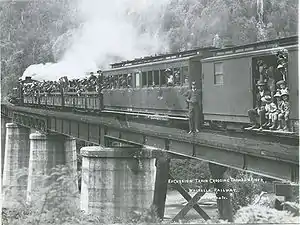 |
| Rail Bridge | H1435 | Noojee Trestle Bridge Rail Trail | Noojee | 37.899583°S 145.985778°E | 1919 | 9 October 1974 | 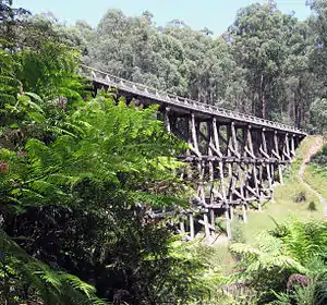 |
| Thomson River Diversion Tunnel Site | H1990 | Thomson River | Walhalla | 37.972222°S 146.424472°E | 1912 | 11 July 2002 | |
| Timber Bridge | H1995 | Bloomfield Rd | Crossover | 38.053222°S 145.966000°E | 1892 | 22 August 2002 | |
| Tramway Bridge | H1444 | Australian Alps Walking Track | Walhalla | 37.931806°S 146.414806°E | 1900 | 20 August 1982 | |
| Walhalla Bandstand | H1315 | Main Road | Walhalla | 37.941472°S 146.451778°E | 1896 | 8 May 1997 | |
| Walhalla Cemetery | H1976 | Main Road | Walhalla | 37.948500°S 146.451417°E | 14 February 2002 | ||
| Warragul Drill Hall | H0600 | 40 Alfred Street | Warragul | 38.166500°S 145.934000°E | 1912-1913 | 13 September 2007 | |
| Warragul Railway Station | H1598 | 122 Queen Street | Warragul | 38.165028°S 145.933083°E | 1915 | 20 August 1982 | 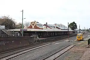 |
| Windsor House | H0326 | Right Hand Branch Road | Walhalla | 37.941944°S 146.453111°E | 1890 | 9 October 1974 |
References
- "Baw Baw Shire". Victorian Heritage Database. Heritage Council of Victoria. Retrieved 15 November 2021.
This article is issued from Wikipedia. The text is licensed under Creative Commons - Attribution - Sharealike. Additional terms may apply for the media files.