List of places on the Victorian Heritage Register in the Shire of Strathbogie
This is a list of places on the Victorian Heritage Register in the Shire of Strathbogie in Victoria, Australia. The Victorian Heritage Register is maintained by the Heritage Council of Victoria.
The Victorian Heritage Register, as of 2021, lists the following fifteen state-registered places within the Shire of Strathbogie:[1]
| Place name | Place # | Location | Suburb or Town | Co-ordinates | Built | Stateregistered | Photo |
|---|---|---|---|---|---|---|---|
| Blacksmiths Shop and Residence | H1376 | 22 Main Street | Strathbogie | 36.856572°S 145.735306°E | c. 1892 | 20 November 1997 | 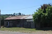 |
| Bridge over Hughes Creek | H1445 | Old Hume Highway | Avenel | 36.907361°S 145.233472°E | 1859 | 20 August 1982 | |
| Calder Woodburn Memorial Avenue | H1975 | Goulburn Valley Highway | Arcadia Kialla West Kialla Arcadia South | 36.582806°S 145.337361°E | 1945-49 | 6 December 2001 | 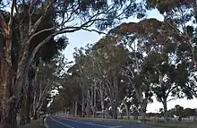 |
| Cameron's Sawmill | H2017 | Reedy Lake Road | Bailieston | 36.702861°S 145.088000°E | 1877 | 20 March 2003 | |
| Chateau Tahbilk | H0296 | 254 O'Neils Road | Tabilk | 36.825192°S 145.085026°E | 1860 | 9 October 1974 | 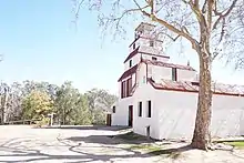 |
| Chinamans Bridge | H1449 | Nagambie-Heathcote Road over the Goulburn River | Nagambie | 36.789111°S 145.123778°E | 1891 | 21 December 1988 | 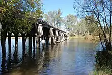 |
| Euroa Court House | H0960 | 99 Binney Street | Euroa | 36.751944°S 145.571972°E | 1892 | 20 August 1982 | .jpg.webp) |
| Former National Bank | H2194 | 1 Binney Street | Euroa | 36.748861°S 145.569667°E | 1884 | 12 February 2009 | 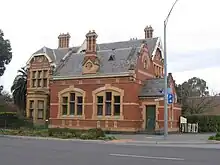 |
| Former Royal Mail Hotel and Cottage | H0335 | 26 Henry Street | Avenel | 36.908194°S 145.231417°E | 1855 | 9 October 1974 | 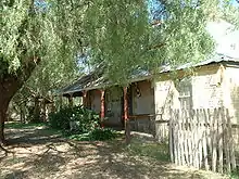 |
| Killeen Homestead | H1908 | 224 Longwood-Mansfield Road | Creightons Creek | 36.837082°S 145.487217°E | 1849 | 15 March 2001 | |
| Kirwans Bridge | H1886 | Kirwans Bridge-Longwood Road over the Goulburn River | Kirwans Bridge | 36.745750°S 145.139972°E | 1890 | 20 July 2000 | 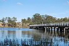 |
| Noorilim | H0297 | 205 Wahring-Murchison East Road | Wahring | 36.667193°S 145.219556°E | c. 1870 | 9 October 1974 | |
| Stone Cellar at Faithfull Creek | H0762 | Hume Highway | Balmattum | 36.720269°S 145.624626°E | 1860s | 20 December 1989 | |
| Strathbogie Aerial Navaid | H0961 | Polly McQuinns Road | Strathbogie | 36.864410°S 145.733600°E | 1936 | 25 March 1993 | |
| Welcome Reef Gully Gold Puddling Site | H1248 | Mt Camel-Graytown Road | Moormbool West | 36.779556°S 144.829528°E | 1890s | 19 December 1996 |
References
- "Strathbogie Shire". Victorian Heritage Database. Heritage Council of Victoria. Retrieved 24 December 2021.
This article is issued from Wikipedia. The text is licensed under Creative Commons - Attribution - Sharealike. Additional terms may apply for the media files.