List of places on the Victorian Heritage Register in the Shire of Yarra Ranges
This is a list of places on the Victorian Heritage Register in the Shire of Yarra Ranges in Victoria, Australia.[1] The Victorian Heritage Register is maintained by the Heritage Council of Victoria.
| Place name | Place # | Location | Suburb or Town | Co-ordinates | Built | Stateregistered | Photo |
|---|---|---|---|---|---|---|---|
| Gulf Station | H0384 | 1029 Melba Highway | Yarra Glen | 37.64715°S 145.38485°E | 1854 | 12 May 1976 | |
| The Towers | H0612 | 6-10 The Eyrie | Lilydale | 37.75517°S 145.35761°E | 1876 | 11 December 1985 | |
| Sanitarium Health Food Company and Signs Publishing Company buildings | H0619 | 51 Main Street | Warburton | 37.75261°S 145.69913°E | 1936 | 19 February 1986 | |
| Yeringberg | H0694 | 810-812 Maroondah Highway | Yering | 37.69013°S 145.43458°E | 1885 | 24 August 1988 | |
| Burnham Beeches | H0868 | 1 Sherbrooke Road | Sherbrooke | 37.8751°S 145.35581°E | 1930 | 27 March 1991 | 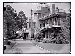 |
| Horatio Jones House | H0957 | 14-16 Blackwood Street | Tecoma | 37.89849°S 145.34315°E | 1926 | 25 March 1993 | |
| Chateau Yering | H1139 | 38-42 Melba Highway | Coldstream | 37.67538°S 145.38264°E | 1854 | 7 December 1995 | |
| Former Healesville Court House | H1171 | 42 Harker Street | Healesville | 37.65635°S 145.51049°E | 1889 | 18 April 1996 | |
| Puffing Billy Railway Trestle Bridge | H1439 | Monbulk Creek, Belgrave-Gembrook Road | Belgrave | 37.90847°S 145.36519°E | 1899 | 20 August 1982 | |
| Healesville Railway Station | H1567 | 38 Healesville-Kinglake Road | Healesville | 37.65494°S 145.50988°E | 1902 | 20 August 1982 | 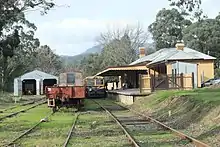 |
| Richards and Sons Logging Winch Site | H1739 | Road 15 | McMahons Creek | 37.79677°S 145.90365°E | 1936 | 20 August 1982 | |
| Mackenzie Cottage, Healesville Sanctuary | H1767 | 25 Badger Creek Road | Badger Creek | 37.68386°S 145.53399°E | 1920 | 7 January 1999 | |
| Old Federal Mill | H1822 | Big Creek Road | McMahons Creek | 37.80378°S 145.8813°E | 1922 | 17 June 1999 | |
| Myrtle Creek Bridge | H1855 | Myrtle Creek, Don Road | Don Valley | 37.71456°S 145.59688°E | 1930 | 18 November 1999 | |
| Longacres | H1876 | 15 Range Road | Olinda | 37.85749°S 145.3623°E | 1924 | 26 October 2000 | |
| Camp Eureka | H1981 | 90-100 Tarrango Road | Yarra Junction | 37.79086°S 145.63942°E | 1946 | 21 March 2002 | |
| Kurth Kiln | H2012 | Soldiers Road | Gembrook | 37.899249°S 145.57549°E | 1940 | 20 March 2003 | |
| Prefabricated Timber House | H2024 | 1029 Melba Highway | Yarra Glen | 37.64855°S 145.3877°E | 1927 | 13 February 2003 | |
| Lilydale Railway Station Refreshment Rooms | H2044 | 99 Main Street | Lilydale | 37.75548°S 145.34771°E | 1914 | 9 October 2003 | 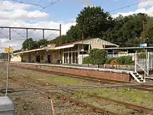 |
| Bickleigh Vale | H2053 | Multiple Buildings | Mooroolbark | 37.79085°S 145.3306°E | 1890 | 25 March 2004 | |
| Mawarra | H2300 | 6 Sherbrooke Road | Sherbrooke | 37.88235°S 145.36211°E | 1925 | 10 May 2012 | |
| Cave Hill Limestone Quarry | H2366 | 4 Melba Avenue | Lilydale | 37.76742°S 145.33882°E | 1878 | 8 June 2017 | |
References
- "VHD". vhd.heritagecouncil.vic.gov.au. Retrieved 13 December 2020.
This article is issued from Wikipedia. The text is licensed under Creative Commons - Attribution - Sharealike. Additional terms may apply for the media files.