List of places on the Victorian Heritage Register in the Rural City of Wangaratta
This is a list of places on the Victorian Heritage Register in the Rural City of Wangaratta in Victoria, Australia. The Victorian Heritage Register is maintained by the Heritage Council of Victoria.
The Victorian Heritage Register, as of 2021, lists the following fifteen state-registered places within the Rural City of Wangaratta:[1]
| Place name | Place # | Location | Suburb or Town | Co-ordinates | Built | Stateregistered | Photo |
|---|---|---|---|---|---|---|---|
| 'Carinya' Ladsons Store | H0568 | 2328 Beechworth-Wangaratta Road | Tarrawingee | 36.389793°S 146.450502°E | 1862 | 6 March 1984 | |
| Bontharambo Homestead | H0359 | 387 Boorhaman Road | Wangaratta | 36.287878°S 146.301219°E | 1857 | 9 October 1974 | |
| Eldorado Dredge | H0386 | 20 Eldorado-Byawatha Road | Eldorado | 36.313750°S 146.502833°E | 1935 | 3 March 1976 | 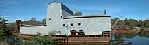 |
| Former ANZ Bank | H0226 | 49-51 Reid Street | Wangaratta | 36.354833°S 146.325583°E | 1875 | 9 October 1974 | |
| Former Flour Mill | H0330 | 62 Woodberrys Lane | Milawa | 36.446222°S 146.406944°E | 1861 | 9 October 1974 | |
| Glenrowan Heritage Precinct | H2000 | Siege Street | Glenrowan | 36.462972°S 146.224000°E | 1880 | 28 November 2002 | |
| Holy Trinity Anglican Cathedral Close | H1065 | Docker Street, Ovens Street, Cusack Street | Wangaratta | 36.355611°S 146.321028°E | 1856 | 14 July 2005 | .jpg.webp) |
| Marianne Gibson Quilt | H2297 | Wangaratta Exhibitions Gallery, 56 Ovens Street | Wangaratta | 36.355889°S 146.322750°E | 1890 | 9 February 2012 | |
| Old School | H0344 | 999 Buckland Gap Road | Murmungee | 36.446944°S 146.692694°E | 1869 | 9 October 1974 | |
| Plough Inn Hotel and Stables | H0360 | 2322 Beechworth-Wangaratta Road | Tarrawingee | 36.389528°S 146.451333°E | 1864 | 9 October 1974 | |
| Wangaratta Railway Station Complex | H1597 | 37 Norton Street | Wangaratta | 36.354917°S 146.317000°E | 1874 | 20 August 1982 | 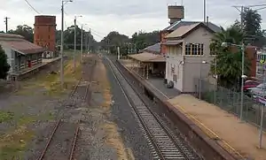 |
| Warra | H0521 | 3 Murdoch Road | Wangaratta | 36.363194°S 146.324861°E | 1908 | 5 May 1982 | |
| Water Tower and Tank | H1833 | 12 Millard Street | Wangaratta | 36.361389°S 146.324972°E | 1902 | 30 September 1999 | |
| Water Wheel and Mine Machinery | H0356 | Weone Mine, Wells Boundary Track | Murmungee | 36.440083°S 146.702667°E | 1939 | 9 October 1974 |
References
- "Wangaratta Rural City". Victorian Heritage Database. Heritage Council of Victoria. Retrieved 24 December 2021.
This article is issued from Wikipedia. The text is licensed under Creative Commons - Attribution - Sharealike. Additional terms may apply for the media files.