List of places on the Victorian Heritage Register in the Shire of Moira
This is a list of places on the Victorian Heritage Register in the Shire of Moira in Victoria, Australia. The Victorian Heritage Register is maintained by the Heritage Council of Victoria.
The Victorian Heritage Register, as of 2021, lists the following eight state-registered places within the Shire of Moira:[1]
| Place name | Place # | Location | Suburb or Town | Co-ordinates | Built | Stateregistered | Photo |
|---|---|---|---|---|---|---|---|
| Barmah Muster Yards | H2212 | Barmah State Forest, Sand Ridge Track | Barmah | 35.960500°S 144.967472°E | 1880 | 11 June 2009 | |
| Barmah Punt | H2164 | Jack Edwards Park, Murray Street | Barmah | 36.018502°S 144.956338°E | 1929 | 10 July 2008 | 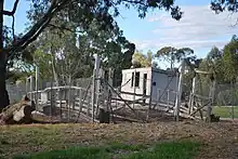 |
| Byramine Homestead | H0370 | 1436 Murray Valley Highway | Burramine | 35.985707°S 145.859217°E | c. 1850s | 9 October 1974 | |
| Coonanga Homestead | H0329 | 575 Bearii-Mywee Road | Strathmerton | 35.872916°S 145.405193°E | 1873 | 9 October 1974 | |
| Mechanics Institute | H0518 | 27-29 Carlisle Street | Wunghnu | 36.153503°S 145.432000°E | 1887 | 18 November 1981 | 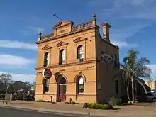 |
| Numurkah Court House | H1479 | 43 Melville Street | Numurkah | 36.089944°S 145.442639°E | 1888 | 20 August 1982 | 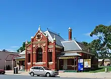 |
| Old Cobram-Barooga Bridge | H2352 | Barooga Road | Cobram | 35.916081°S 145.669418°E | 1902 | 11 February 2016 | 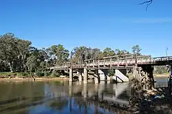 |
| Yarrawonga Court House | H1655 | 12 Piper Street | Yarrawonga | 36.010919°S 146.002295°E | 1887 | 20 August 1982 | 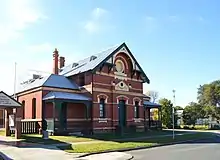 |
References
- "Moira Shire". Victorian Heritage Database. Heritage Council of Victoria. Retrieved 30 November 2021.
This article is issued from Wikipedia. The text is licensed under Creative Commons - Attribution - Sharealike. Additional terms may apply for the media files.