Núcleo Bandeirante
Núcleo Bandeirante is an administrative region in the Federal District in Brazil. It is located to the west of Paranoá Lake, being bordered by Arniqueira, Park Way, and Guará to the north, Candangolândia to the east, and Park Way and Riacho Fundo to the south. It was founded 19 December 1956.
Núcleo Bandeirante | |
|---|---|
| Região Administrativa de Núcleo Bandeirante Administrative Region of Núcleo Bandeirante | |
 Flag | |
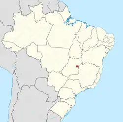
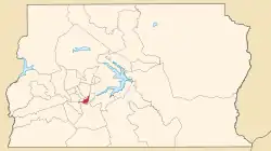 Localization of Núcleo Bandeirante in Federal District | |
| Coordinates: 15°52′12″S 47°58′04″W | |
| Country | |
| Region | Central-West |
| State | |
| Founded | December 19, 1956 |
| Government | |
| • Regional administrator | Cláudio Márcio de Oliveira |
| Area | |
| • Total | 80.43 km2 (31.05 sq mi) |
| Population (2010)[1] | |
| • Total | 26,089 |
| Time zone | UTC−3 (BRT) |
| Postal Code (CEP) | 71700-000 |
| Area code | +55 61 |
| Website | www.bandeirante.df.gov.br |
Geography
Núcleo Bandeirante is located in the Brazilian Highlands, at an altitute of 1,000 metres (3,300 ft).
Climate
| Climate data for Núcleo Bandeirante (1991–2020, extremes 1961–present) | |||||||||||||
|---|---|---|---|---|---|---|---|---|---|---|---|---|---|
| Month | Jan | Feb | Mar | Apr | May | Jun | Jul | Aug | Sep | Oct | Nov | Dec | Year |
| Record high °C (°F) | 32.6 (90.7) |
32.0 (89.6) |
32.1 (89.8) |
31.6 (88.9) |
31.6 (88.9) |
31.6 (88.9) |
30.8 (87.4) |
33.0 (91.4) |
35.7 (96.3) |
36.4 (97.5) |
34.5 (94.1) |
33.7 (92.7) |
36.4 (97.5) |
| Average high °C (°F) | 26.9 (80.4) |
27.2 (81.0) |
27.0 (80.6) |
26.8 (80.2) |
26.0 (78.8) |
25.3 (77.5) |
25.6 (78.1) |
27.4 (81.3) |
29.1 (84.4) |
29.0 (84.2) |
27.0 (80.6) |
26.8 (80.2) |
27.0 (80.6) |
| Daily mean °C (°F) | 21.9 (71.4) |
21.9 (71.4) |
21.8 (71.2) |
21.6 (70.9) |
20.3 (68.5) |
19.3 (66.7) |
19.3 (66.7) |
21.0 (69.8) |
22.8 (73.0) |
23.1 (73.6) |
21.7 (71.1) |
21.7 (71.1) |
21.4 (70.5) |
| Average low °C (°F) | 18.3 (64.9) |
18.2 (64.8) |
18.2 (64.8) |
17.7 (63.9) |
15.6 (60.1) |
14.2 (57.6) |
13.9 (57.0) |
15.3 (59.5) |
17.6 (63.7) |
18.5 (65.3) |
18.1 (64.6) |
18.3 (64.9) |
17.0 (62.6) |
| Record low °C (°F) | 12.2 (54.0) |
11.0 (51.8) |
14.5 (58.1) |
10.7 (51.3) |
3.2 (37.8) |
3.3 (37.9) |
1.6 (34.9) |
5.0 (41.0) |
9.0 (48.2) |
10.2 (50.4) |
11.4 (52.5) |
11.4 (52.5) |
1.6 (34.9) |
| Average precipitation mm (inches) | 206.0 (8.11) |
179.5 (7.07) |
226.0 (8.90) |
145.2 (5.72) |
26.9 (1.06) |
3.3 (0.13) |
1.5 (0.06) |
16.3 (0.64) |
38.1 (1.50) |
141.8 (5.58) |
253.1 (9.96) |
241.1 (9.49) |
1,478.8 (58.22) |
| Average precipitation days (≥ 1.0 mm) | 16 | 14 | 15 | 9 | 3 | 1 | 0 | 2 | 4 | 10 | 17 | 18 | 109 |
| Average relative humidity (%) | 74.7 | 74.2 | 76.1 | 72.2 | 65.4 | 58.8 | 51.0 | 43.5 | 46.4 | 58.8 | 74.5 | 76.0 | 64.3 |
| Mean monthly sunshine hours | 159.6 | 158.9 | 168.7 | 200.8 | 237.9 | 247.6 | 268.3 | 273.5 | 225.7 | 191.3 | 138.3 | 145.0 | 2,415.6 |
| Source 1: INMET | |||||||||||||
| Source 2: Meteo Climat (record highs and lows)[2] | |||||||||||||
Government
As with other administrative regions, the government of Núcleo Bandeirante is the Regional Administration. In a different fashion to municipalities, the Administrative Regions are administered by Regional Administrations, which are led by an administrator. Each administration is responsible for providing services to their respective regions, such as power, water, sanitation, and road infrastructure. The current administrator for Núcleo Bandeirante is Cláudio Márcio de Oliveira.[3]
References
- "Pesquisa Distrital por Amostra de Domicílios - 2010/2011" (PDF) (in Portuguese). Codeplan. Retrieved 2013-04-12.
- "Station Brasília" (in French). Meteo Climat. Retrieved 24 March 2022.
- "Perfil do Administrador – Administração Regional do Núcleo Bandeirante" (in Brazilian Portuguese). Retrieved 2023-08-25.