Paranoá, Federal District
Paranoá is an administrative region in the Federal District in Brazil. It is located to the east of Paranoá Lake, being bordered by Lago Norte, Itapoã and Planaltina to the north, São Sebastião and Jardim Botânico to the south. It shares a border with Lago Sul and Brasília through Paranoá Lake. It was formed on 10 December 1964. As of a 2010 census, it has a population of 46,527.
Paranoá | |
|---|---|
| Região Administrativa de Paranoá Administrative Region of Paranoá | |
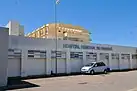
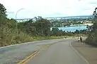
Clockwise from top: I love Paranoá sign; Paranoá Regional Hospital; Road near Paranoá Lake; Paranoá bus terminal; Paranoá residential block | |
 Flag | |
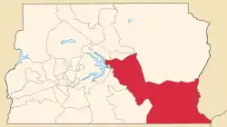 Localization of Paranoá in Federal District | |
| Coordinates: 15°46′07″S 47°46′47″W | |
| Country | |
| Region | Central-West |
| State | |
| Founded | December 10, 1964 |
| Government | |
| • Regional administrator | Sévulo José Filho[1] |
| Area | |
| • Total | 853.33 km2 (329.47 sq mi) |
| Population (2010)[2] | |
| • Total | 46,527 |
| Time zone | UTC-3 (UTC-3) |
| • Summer (DST) | UTC-2 (UTC-2) |
| Postal Code (CEP) | 71570-000 |
| Area code | +55 61 |
| Website | www.paranoa.df.gov.br |

.jpg.webp)

Etymology
The name Paranoá comes from Paranoá Lake, which the region is located near.
References
- "Perfil do administrador" (in Portuguese). Administração Regional de Paranoá, DF. Retrieved 2015-01-01.
- "Pesquisa Distrital por Amostra de Domicílios - 2010/2011" (PDF) (in Portuguese). Codeplan. Retrieved 2013-04-12.
External links
Wikimedia Commons has media related to Paranoá.
This article is issued from Wikipedia. The text is licensed under Creative Commons - Attribution - Sharealike. Additional terms may apply for the media files.