Park Way
Park Way is an administrative region in the Federal District in Brazil. It is located southwest of Paranoá Lake. Consisting of two separated portions, it is bordered clockwise by Águas Claras, Guará, Núcleo Bandeirante, and Arniqueira in its northern half; and Núcleo Bandeirante, Candangolândia, Lago Sul, Jardim Botânico, Santa Maria, Gama, Riacho Fundo and Riacho Fundo II in its southern half.
Park Way | |
|---|---|
| Região Administrativa de Park Way Administrative Region of Park Way | |
 Flag | |
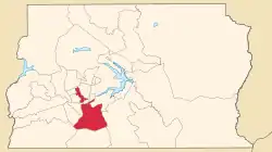 Location of Park Way in the Federal District | |
| Coordinates: 15°54′25″S 47°57′53″W | |
| Country | |
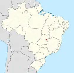
| Region | Central-West |
| State | |
| Established | 29 December 2003 |
| Government | |
| • Regional administrator | Abdon Luiz de Sousa de Barros |
| Area | |
| • Total | 76.47 km2 (29.53 sq mi) |
| Population | |
| • Total | 20,511 |
| • Density | 270/km2 (690/sq mi) |
| Time zone | UTC−3 (BRT) |
| Area code | +55 61 |
| Website | www |
References
External links
Wikimedia Commons has media related to Park Way.
This article is issued from Wikipedia. The text is licensed under Creative Commons - Attribution - Sharealike. Additional terms may apply for the media files.