Rohaniya
Rohaniya is a village and corresponding community development block in Unchahar tehsil of Rae Bareli district, Uttar Pradesh, India.[2] It is located 43 km from Raebareli, the district headquarters.[3] As of 2011, Rohaniya has a population of 3,880 people, in 751 households.[2] It has one primary school and no healthcare facilities.[2]
Rohaniya
Rohniya, Rohania | |
|---|---|
Village | |
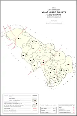 Map of Rohaniya CD block | |
 Rohaniya Location in Uttar Pradesh, India | |
| Coordinates: 25.979102°N 81.383082°E[1] | |
| Country India | |
| State | Uttar Pradesh |
| District | Raebareli |
| Area | |
| • Total | 7.705 km2 (2.975 sq mi) |
| Population (2011)[2] | |
| • Total | 3,880 |
| • Density | 500/km2 (1,300/sq mi) |
| Languages | |
| • Official | Hindi |
| Time zone | UTC+5:30 (IST) |
| Vehicle registration | UP-35 |
The 1961 census recorded Rohaniya (as "Rohania") as comprising 8 hamlets, with a total population of 1,488 people (732 male and 756 female), in 337 households and 335 physical houses.[4] The area of the village was given as 1,904 acres and was electrified at that point.[4]
The 1981 census recorded Rohaniya as having a population of 2,126 people, in 430 households, and having an area of 770.52 hectares.[3] The main staple foods were listed as wheat and rice.[3]
Villages
Rohaniya CD block has the following 53 villages:[2]
| Village name | Total land area (hectares) | Population (in 2011) |
|---|---|---|
| Ram Ganj | 172.2 | 0 |
| Itaura Buzurg | 2,014 | 13,851 |
| Salarpur | 74.2 | 442 |
| Aihari Buzurg | 152.7 | 1,101 |
| Tamas Garh | 102 | 400 |
| Khan Alampur Sathara | 138.2 | 605 |
| Dharupur | 152.3 | 318 |
| Mirazapur Aihari | 545.9 | 2,948 |
| Dhamauli | 176.7 | 751 |
| Sikandarabad | 72.7 | 4 |
| Rohaniya (block headquarters) | 770.5 | 3,880 |
| Patti Pitha | 24.7 | 384 |
| Neknampur | 115.2 | 177 |
| Raipur | 312 | 1,256 |
| Sumer Bag | 127 | 337 |
| Dhaurhara | 43.6 | 680 |
| Masaudabad | 140.6 | 422 |
| Usarauna | 532.9 | 3,380 |
| Marha Mau | 213.3 | 0 |
| Rasoolpur | 927.2 | 7,671 |
| Salimpur Baherwar | 102.2 | 1,232 |
| Sarain Akhtiyar | 95.2 | 1,731 |
| Bandai | 168 | 227 |
| Loharani | 26.8 | 187 |
| Matrampur | 204.1 | 1,456 |
| Suhapar | 78.1 | 196 |
| Hari Vanshpur | 38.9 | 286 |
| Itaili | 125.2 | 1,171 |
| Chak Bhira | 48 | 401 |
| Baramjitpur Urf Khwata | 10 | 615 |
| Bhikhnapur Kalapur | 61 | 428 |
| Hamidpur Bara Gaon | 21 | 1,105 |
| Alinagar Askaran | 101.2 | 945 |
| Chhatauna Bhariyani | 150 | 1,775 |
| Raghunathpur Labedawa | 34 | 381 |
| Hajaribag | 31 | 342 |
| Gagahara Gulal Ganj | 291 | 2,361 |
| Raghunathpur Paterwa | 34 | 381 |
| Umaran | 664.1 | 4,786 |
| Dakpur | 67 | 297 |
| Kamalpur | 288 | 1,235 |
| Pure Khiro Dhar | 38 | 651 |
| Bachhaiyyapur | 173 | 505 |
| Lakshman Ganj | 143 | 73 |
| Samasapur Patauna | 97 | 600 |
| Parsipur | 52 | 552 |
| Sarakpur | 139 | 953 |
| Prayagpur Nandaura | 174 | 1,862 |
| Nandaura Mafi | 50 | 583 |
| Sareni | 201 | 1,864 |
| Mawai | 247 | 1,809 |
| Gaura | 44 | 351 |
References
- "GeoNames Search". geonames.nga.mil. Archived from the original on 12 April 2014. Retrieved 29 August 2023.
- "Census of India 2011: Uttar Pradesh District Census Handbook - Rae Bareli, Part A (Village and Town Directory)" (PDF). Census 2011 India. pp. 365–74. Retrieved 21 August 2021.
- Census 1981 Uttar Pradesh: District Census Handbook Part XIII-A: Village & Town Directory, District Rae Bareli (PDF). 1982. pp. 228–9. Retrieved 21 August 2021.
- Census 1961: District Census Handbook, Uttar Pradesh (39 - Raebareli District) (PDF). Lucknow. 1965. pp. cxii-cxiii of section "Salon Tahsil". Retrieved 21 August 2021.
{{cite book}}: CS1 maint: location missing publisher (link)