Seyssel, Ain
Seyssel (French pronunciation: [sɛsɛl]; Arpitan: Sèssél) is a commune in the Ain department in eastern France.
Seyssel | |
|---|---|
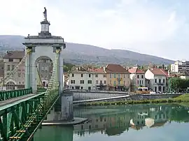 Town center seen from Seyssel, Haute-Savoie | |
.svg.png.webp) Coat of arms | |
Location of Seyssel | |
 Seyssel  Seyssel | |
| Coordinates: 45°58′00″N 5°50′00″E | |
| Country | France |
| Region | Auvergne-Rhône-Alpes |
| Department | Ain |
| Arrondissement | Belley |
| Canton | Plateau d'Hauteville |
| Intercommunality | CC Usses et Rhône |
| Government | |
| • Mayor (2020–2026) | Michel Botteri[1] |
| Area 1 | 2.40 km2 (0.93 sq mi) |
| Population | 1,006 |
| • Density | 420/km2 (1,100/sq mi) |
| Time zone | UTC+01:00 (CET) |
| • Summer (DST) | UTC+02:00 (CEST) |
| INSEE/Postal code | 01407 /01420 |
| Elevation | 250–332 m (820–1,089 ft) (avg. 258 m or 846 ft) |
| 1 French Land Register data, which excludes lakes, ponds, glaciers > 1 km2 (0.386 sq mi or 247 acres) and river estuaries. | |
It lies on the west bank of the Rhône.
The part of the town across the Rhône is also named Seyssel but located in the Haute-Savoie department, and is locally referred as Seyssel-Savoie. It is a rare case in France of two homonymous communes adjacent to each other, similar to the situation of the village of Saint-Santin, divided between the communes of Saint-Santin (Aveyron) and Saint-Santin-de-Maurs (Cantal).
Population
|
|
See also
- Communes of the Ain department
- Pont de la Vierge noire
- Pont de Seyssel
References
- "Répertoire national des élus: les maires" (in French). data.gouv.fr, Plateforme ouverte des données publiques françaises. 13 September 2022.
- "Populations légales 2020". The National Institute of Statistics and Economic Studies. 29 December 2022.
Wikimedia Commons has media related to Seyssel, Ain.
This article is issued from Wikipedia. The text is licensed under Creative Commons - Attribution - Sharealike. Additional terms may apply for the media files.