2016 United States presidential election in Montana
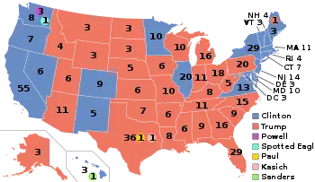
The 2016 United States presidential election in Montana was held on Tuesday, November 8, 2016, as part of the 2016 United States presidential election in which all 50 states plus the District of Columbia participated. Montana voters chose electors to represent them in the Electoral College via a popular vote, pitting the Republican Party's nominee, businessman Donald Trump, and running mate Indiana Governor Mike Pence against Democratic Party nominee, former Secretary of State Hillary Clinton, and her running mate Virginia Senator Tim Kaine. Montana has three electoral votes in the Electoral College.[2]
| |||||||||||||||||||||||||||||||||
| Turnout | 64.30% [1] | ||||||||||||||||||||||||||||||||
|---|---|---|---|---|---|---|---|---|---|---|---|---|---|---|---|---|---|---|---|---|---|---|---|---|---|---|---|---|---|---|---|---|---|
| |||||||||||||||||||||||||||||||||
| |||||||||||||||||||||||||||||||||
| |||||||||||||||||||||||||||||||||

| Elections in Montana |
|---|
 |
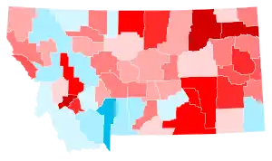
Trump carried the state by a 20.4% margin of victory, exceeding Mitt Romney's 13.7% margin in 2012 and John McCain's 2.4% margin in 2008. Republicans have won Montana in every presidential election since 1996. Libertarian nominee and third-party candidate Gary Johnson received 5.6% of the vote.
This was Johnson's fifth strongest state, behind his native New Mexico as well as North Dakota, Alaska, and Oklahoma.
Primary elections
Democratic primary
Two candidates appeared on the Democratic presidential primary ballot:
| Montana Democratic primary, June 7, 2016 | |||||
|---|---|---|---|---|---|
| Candidate | Popular vote | Estimated delegates | |||
| Count | Percentage | Pledged | Unpledged | Total | |
| Bernie Sanders | 65,156 | 51.56% | 11 | 1 | 12 |
| Hillary Clinton | 55,805 | 44.16% | 10 | 5 | 15 |
| No preference | 5,415 | 4.28% | 0 | 0 | 0 |
| Uncommitted | — | 0 | 0 | 0 | |
| Total | 126,376 | 100% | 21 | 6 | 27 |
| Source: The Green Papers, Montana Secretary of State - Official Primary Results | |||||
Republican primary
Five candidates appeared on the Republican presidential primary ballot:
- Jeb Bush (withdrawn)
- Ted Cruz (withdrawn)
- John Kasich (withdrawn)
- Marco Rubio (withdrawn)
- Donald Trump
| Candidate | Votes | Percentage | Actual delegate count | ||
|---|---|---|---|---|---|
| Bound | Unbound | Total | |||
| Donald Trump | 115,594 | 73.68% | 27 | 0 | 27 |
| Ted Cruz (withdrawn) | 14,682 | 9.36% | 0 | 0 | 0 |
| John Kasich (withdrawn) | 10,777 | 6.87% | 0 | 0 | 0 |
| No preference | 7,369 | 4.70% | 0 | 0 | 0 |
| Marco Rubio (withdrawn) | 5,192 | 3.31% | 0 | 0 | 0 |
| Jeb Bush (withdrawn) | 3,274 | 2.09% | 0 | 0 | 0 |
| Unprojected delegates: | 0 | 0 | 0 | ||
| Total: | 156,888 | 100.00% | 27 | 0 | 27 |
| Source: The Green Papers | |||||
General election
Predictions
| Source | Ranking | As of |
|---|---|---|
| CNN[3] | Safe R | November 4, 2016 |
| Cook Political Report[4] | Safe R | November 7, 2016 |
| Electoral-vote.com[5] | Safe R | November 7, 2016 |
| Rothenberg Political Report[6] | Safe R | November 7, 2016 |
| NBC[7] | Lean R | November 7, 2016 |
| RealClearPolitics[8] | Likely R | November 7, 2016 |
Results
| Party | Candidate | Votes | % | ||
|---|---|---|---|---|---|
| Republican | 279,240 | 56.17 | |||
| Democratic | 177,709 | 35.75 | |||
| Libertarian | 28,037 | 5.64 | |||
| Green | 7,970 | 1.60 | |||
| Independent |
|
2,297 | 0.46 | ||
| American Delta | 1,570 | 0.32 | |||
| Constitution |
|
296 | 0.06 | ||
| American |
|
10 | 0.00 | ||
| Independent | 7 | 0.00 | |||
| Independent | 3 | 0.00 | |||
| Independent | Robert Buchanan (write-in) | 2 | 0.00 | ||
| Independent |
|
1 | 0.00 | ||
| Independent | 1 | 0.00 | |||
| Socialist | 1 | 0.00 | |||
| Libertarian | Darryl Perry (write-in) | 1 | 0.00 | ||
| Independent | Joe Schriner (write-in) | 1 | 0.00 | ||
| Independent | Laio Morris (write-in) | 1 | 0.00 | ||
| Total votes | 497,147 | 100% | |||
| Republican win | |||||
Results by county
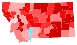
Preliminary general election results for president as of 14 December 2016 by county. Totals exclude 2,621 write-in votes.[11]
| County | Clinton% | Clinton# | Trump% | Trump# | Others% | Others# | Total |
|---|---|---|---|---|---|---|---|
| Beaverhead | 23.57% | 1143 | 69.15% | 3353 | 7.28% | 353 | 4849 |
| Big Horn | 49.57% | 2094 | 43.87% | 1853 | 6.56% | 277 | 4224 |
| Blaine | 45.00% | 1202 | 47.47% | 1268 | 7.53% | 201 | 2671 |
| Broadwater | 18.30% | 573 | 74.97% | 2348 | 6.74% | 211 | 3132 |
| Carbon | 30.64% | 1828 | 62.81% | 3748 | 6.55% | 391 | 5967 |
| Carter | 8.99% | 70 | 87.03% | 678 | 3.98% | 31 | 779 |
| Cascade | 35.41% | 12175 | 57.10% | 19632 | 7.49% | 2577 | 34384 |
| Chouteau | 28.27% | 732 | 64.85% | 1679 | 6.88% | 178 | 2589 |
| Custer | 22.68% | 1176 | 70.53% | 3657 | 6.79% | 352 | 5185 |
| Daniels | 17.59% | 168 | 76.44% | 730 | 5.97% | 57 | 955 |
| Dawson | 18.17% | 787 | 76.66% | 3320 | 5.17% | 224 | 4331 |
| Deer Lodge | 49.07% | 2058 | 42.04% | 1763 | 8.89% | 373 | 4194 |
| Fallon | 10.38% | 154 | 86.19% | 1279 | 3.44% | 51 | 1484 |
| Fergus | 20.58% | 1202 | 73.10% | 4269 | 6.32% | 369 | 5840 |
| Flathead | 28.59% | 13293 | 65.04% | 30240 | 6.37% | 2961 | 46494 |
| Gallatin | 45.50% | 24246 | 44.66% | 23802 | 9.84% | 5244 | 53292 |
| Garfield | 4.75% | 34 | 91.20% | 653 | 4.05% | 29 | 716 |
| Glacier | 61.67% | 3121 | 32.01% | 1620 | 6.32% | 320 | 5061 |
| Golden Valley | 15.07% | 71 | 77.49% | 365 | 7.43% | 35 | 471 |
| Granite | 26.59% | 472 | 67.15% | 1192 | 6.25% | 111 | 1775 |
| Hill | 36.90% | 2371 | 54.12% | 3478 | 8.98% | 577 | 6426 |
| Jefferson | 29.96% | 1998 | 62.64% | 4177 | 7.39% | 493 | 6668 |
| Judith Basin | 19.57% | 235 | 72.61% | 872 | 7.83% | 94 | 1201 |
| Lake | 36.43% | 4776 | 57.44% | 7530 | 6.13% | 804 | 13110 |
| Lewis and Clark | 42.28% | 14478 | 49.34% | 16895 | 8.39% | 2872 | 34245 |
| Liberty | 21.55% | 206 | 73.01% | 698 | 5.44% | 52 | 956 |
| Lincoln | 21.98% | 2041 | 72.48% | 6729 | 5.54% | 514 | 9284 |
| Madison | 24.88% | 1180 | 69.51% | 3297 | 5.61% | 266 | 4743 |
| McCone | 14.53% | 154 | 81.32% | 862 | 4.15% | 44 | 1060 |
| Meagher | 19.79% | 193 | 74.77% | 729 | 5.44% | 53 | 975 |
| Mineral | 25.91% | 519 | 66.40% | 1330 | 7.69% | 154 | 2003 |
| Missoula | 53.44% | 31543 | 37.70% | 22250 | 8.87% | 5233 | 59026 |
| Musselshell | 13.74% | 332 | 81.42% | 1967 | 4.84% | 117 | 2416 |
| Park | 38.63% | 3595 | 53.51% | 4980 | 7.86% | 731 | 9306 |
| Petroleum | 9.32% | 30 | 86.34% | 278 | 4.35% | 14 | 322 |
| Phillips | 14.72% | 318 | 79.73% | 1723 | 5.55% | 120 | 2161 |
| Pondera | 27.17% | 738 | 66.24% | 1799 | 6.59% | 179 | 2716 |
| Powder River | 12.08% | 127 | 84.11% | 884 | 3.81% | 40 | 1051 |
| Powell | 19.72% | 551 | 72.62% | 2029 | 7.66% | 214 | 2794 |
| Prairie | 14.51% | 100 | 80.70% | 556 | 4.79% | 33 | 689 |
| Ravalli | 27.85% | 6223 | 66.28% | 14810 | 5.88% | 1313 | 22346 |
| Richland | 13.84% | 671 | 80.63% | 3908 | 5.53% | 268 | 4847 |
| Roosevelt | 42.76% | 1560 | 49.26% | 1797 | 7.98% | 291 | 3648 |
| Rosebud | 28.69% | 987 | 65.49% | 2253 | 5.81% | 200 | 3440 |
| Sanders | 20.61% | 1218 | 72.52% | 4286 | 6.87% | 406 | 5910 |
| Sheridan | 26.04% | 477 | 67.74% | 1241 | 6.22% | 114 | 1832 |
| Silver Bow | 52.43% | 8619 | 38.79% | 6376 | 8.78% | 1444 | 16439 |
| Stillwater | 18.66% | 908 | 75.24% | 3661 | 6.10% | 297 | 4866 |
| Sweet Grass | 19.14% | 402 | 75.95% | 1595 | 4.90% | 103 | 2100 |
| Teton | 25.42% | 808 | 68.26% | 2170 | 6.32% | 201 | 3179 |
| Toole | 19.80% | 402 | 73.74% | 1497 | 6.45% | 131 | 2030 |
| Treasure | 13.32% | 59 | 79.23% | 351 | 7.45% | 33 | 443 |
| Valley | 22.86% | 886 | 69.61% | 2698 | 7.53% | 292 | 3876 |
| Wheatland | 18.96% | 179 | 74.36% | 702 | 6.67% | 63 | 944 |
| Wibaux | 10.24% | 55 | 86.22% | 463 | 3.54% | 19 | 537 |
| Yellowstone | 32.35% | 22171 | 59.70% | 40920 | 7.96% | 5453 | 68544 |
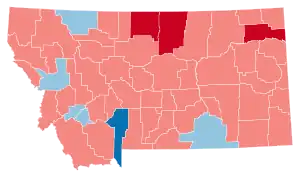
Counties that flipped from Democratic to Republican
By congressional district
Due to the state's low population, only one congressional district is allocated, the At-Large District. This district covers the entire state, and thus is equivalent to the statewide election results.
| District | Trump | Clinton | Representative |
|---|---|---|---|
| At-large | 56.17% | 35.25% | Ryan Zinke |
Analysis
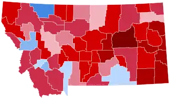
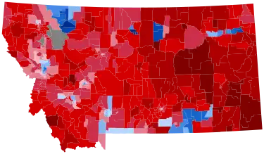
Like every Republican nominee since 1996, Donald Trump carried Montana's three electoral votes. He won by a large margin, and he swept most of the plains counties in eastern Montana, traditionally the most conservative part of the state, by staggering margins sometimes exceeding 60 points. The eastern part of the state has benefited from the recent energy boom in neighboring North Dakota, and its populace is suspicious and disapproving of the environmental movement championed by Democrats in recent elections.
Most counties in the western part of the state were also traditionally Republican, with a ranching-based economy heavily dependent on the raising and production of cattle and hay, particularly in the counties bordering Idaho such as Beaverhead County and Ravalli County. However, an influx of retirees from the West Coast have made the western region more competitive in recent elections.[12]
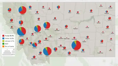
The only significant counties won by Clinton were Missoula County, where the city of Missoula is located, Gallatin County, where Bozeman is located, and Big Horn County and Glacier County, which are both majority Native American. While sweeping most of the rural, majority white conservative counties of the state, Trump also won in Lewis and Clark County where the capital city of Helena is located, in neighboring Cascade County where Great Falls is located, and in Yellowstone County where the city of Billings is located.[13]
Trump became the first Republican to win the White House without carrying Gallatin County since William McKinley in 1900. He was the first Republican to carry Roosevelt County since 1984.
See also
References
- "Voter turnout in United States elections".
- "Distribution of Electoral Votes". National Archives and Records Administration. September 19, 2019. Retrieved November 29, 2020.
- Chalian, David (November 4, 2016). "Road to 270: CNN's new election map". CNN. Retrieved February 17, 2019.
- "2016 Electoral Scorecard". The Cook Political Report. November 7, 2016. Retrieved February 17, 2019.
- "2016 Predicted Electoral Map". Electoral-vote.com. Retrieved February 17, 2019.
- "Presidential Ratings". The Rothenberg Political Report. Retrieved August 16, 2021.
- Todd, Chuck (November 7, 2016). "NBC's final battleground map shows a lead for Clinton". NBC News. Retrieved February 17, 2019.
- "2016 Election Maps - Battle for White House". RealClearPolitics. Retrieved February 17, 2019.
- Federal Election Commission (December 2017). "Federal Elections 2016" (PDF). p. 35. Retrieved November 13, 2021.
- Montana Secretary of State. "2016 General Election Official State-Filed Write-In Candidates" (PDF). Retrieved November 14, 2021.
- 2016 Statewide General Election Canvass (PDF) Montana Secretary Of State Linda McCulloch. Accessed December 14, 2016.
- Cohen, Micah (June 21, 2012). "Presidential Geography: Montana". FiveThirtyEight. Retrieved November 26, 2016.
- "Montana Election Results 2016". The New York Times. Retrieved November 26, 2016.
.jpg.webp)


