National Register of Historic Places listings in Coffee County, Tennessee
This is a list of the National Register of Historic Places listings in Coffee County, Tennessee.
Location of Coffee County in Tennessee
This is intended to be a complete list of the properties and districts on the National Register of Historic Places in Coffee County, Tennessee, United States. Latitude and longitude coordinates are provided for many National Register properties and districts; these locations may be seen together in a map.[1]
There are 16 properties and districts listed on the National Register in the county, and one former listing.
| Anderson – Bedford – Benton – Bledsoe – Blount – Bradley – Campbell – Cannon – Carroll – Carter – Cheatham – Chester – Claiborne – Clay – Cocke – Coffee – Crockett – Cumberland – Davidson – Decatur – DeKalb – Dickson – Dyer – Fayette – Fentress – Franklin – Gibson – Giles – Grainger – Greene – Grundy – Hamblen – Hamilton – Hancock – Hardeman – Hardin – Hawkins – Haywood – Henderson – Henry – Hickman – Houston – Humphreys – Jackson – Jefferson – Johnson – Knox – Lake – Lauderdale – Lawrence – Lewis – Lincoln – Loudon – Macon – Madison – Marion – Marshall – Maury – McMinn – McNairy – Meigs – Monroe – Montgomery – Moore – Morgan – Obion – Overton – Perry – Pickett – Polk – Putnam – Rhea – Roane – Robertson – Rutherford – Scott – Sequatchie – Sevier – Shelby – Smith – Stewart – Sullivan – Sumner – Tipton – Trousdale – Unicoi – Union – Van Buren – Warren – Washington – Wayne – Weakley – White – Williamson – Wilson |
This National Park Service list is complete through NPS recent listings posted October 20, 2023.[2]
Current listings
| [3] | Name on the Register[4] | Image | Date listed[5] | Location | City or town | Description |
|---|---|---|---|---|---|---|
| 1 | Cascade Distillery Site | 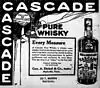 Cascade Distillery Site |
June 10, 1994 (#94000578) |
Western side of Cascade Dr., about 0.7 miles northwest of the junction with Riley Creek Rd. 35°25′14″N 86°14′21″W |
Normandy | The original site of the George Dickel distillery, the current site of which lies just to the north |
| 2 | Coffee County Courthouse |  Coffee County Courthouse |
February 12, 1974 (#74001905) |
Public Sq. 35°28′59″N 86°05′20″W |
Manchester | Built in 1871 |
| 3 | Crouch-Ramsey Family Farm | 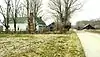 Crouch-Ramsey Family Farm |
August 5, 2005 (#05000830) |
3016 Hickory Grove Rd. 35°32′41″N 85°57′28″W |
Summitville | Tennessee Century Farm established by Thomas Cunningham in 1901; house and log barn date to the 19th century |
| 4 | Farrar Distillery | September 27, 1984 (#84003472) |
Noah Fork Rd. 35°34′50″N 86°10′18″W |
Noah | ||
| 5 | Fox House | 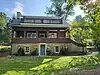 Fox House |
June 21, 2023 (#100009078) |
502 Lake Hills Rd. 35°24′36″N 86°12′04″W |
Tullahoma | |
| 6 | L.D. Hickerson House | 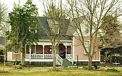 L.D. Hickerson House |
August 18, 1993 (#89001395) |
215 N. Washington St. 35°21′56″N 86°12′36″W |
Tullahoma | Built in 1895 by Lytle David Hickerson |
| 7 | John H. Leming House | 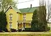 John H. Leming House |
March 21, 2011 (#11000092) |
414 E. Main St. 35°28′56″N 86°04′59″W |
Manchester | Built by John Leming in 1899 |
| 8 | Normandy Dam Project |  Normandy Dam Project |
August 11, 2017 (#100001464) |
Frank Hiles Rd. E of Coffee-Bedford County Line 35°27′56″N 86°14′33″W |
Normandy | |
| 9 | North Atlantic Street Historic District | 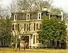 North Atlantic Street Historic District |
July 14, 1988 (#88001052) |
200-500 blocks of N. Atlantic St. 35°21′58″N 86°12′43″W |
Tullahoma | Victorian houses built in the late 19th century for merchants and railroad managers |
| 10 | North Washington Street Historic District | 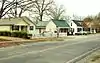 North Washington Street Historic District |
August 18, 1993 (#89001396) |
603-611 N. Washington St. 35°22′12″N 86°12′50″W |
Tullahoma | 1920s-era cottages built for railroad workers |
| 11 | Old Stone Fort | 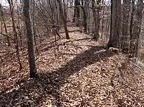 Old Stone Fort |
February 20, 1973 (#73001757) |
West of Manchester 35°28′59″N 86°06′29″W |
Manchester | |
| 12 | Smotherman House | 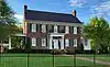 Smotherman House |
July 25, 2018 (#100002747) |
211 W Blackwell St. 35°21′59″N 86°13′00″W |
Tullahoma | |
| 13 | T-201 Aircraft Hangar | T-201 Aircraft Hangar |
June 28, 2021 (#100006711) |
707 William Northern Blvd. (Tullahoma Regional Airport) 35°22′49″N 86°14′27″W |
Tullahoma | |
| 14 | Tullahoma Municipal Building | 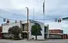 Tullahoma Municipal Building |
July 30, 2018 (#100002748) |
201 W Grundy St. 35°21′45″N 86°12′45″W |
Tullahoma | |
| 15 | Wilkinson-Keele House | 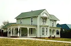 Wilkinson-Keele House |
November 15, 2006 (#06001040) |
313 S. Ramsey St. 35°28′55″N 86°05′03″W |
Manchester | Built in 1888 |
| 16 | Wilson-Crouch House | 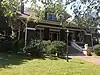 Wilson-Crouch House |
November 20, 2017 (#100001820) |
216 S. Jackson St. 35°21′35″N 86°12′34″W |
Tullahoma |
Former listings
| [3] | Name on the Register | Image | Date listed | Date removed | Location | City or town | Description |
|---|---|---|---|---|---|---|---|
| 1 | Manchester Cumberland Presbyterian Church | June 29, 1992 (#92000781) | October 28, 2021 | Junction of Church and W. High Sts. 35°29′04″N 86°05′26″W |
Manchester |
See also
Wikimedia Commons has media related to National Register of Historic Places in Coffee County, Tennessee.
References
- The latitude and longitude information provided in this table was derived originally from the National Register Information System, which has been found to be fairly accurate for about 99% of listings. Some locations in this table may have been corrected to current GPS standards.
- National Park Service, United States Department of the Interior, "National Register of Historic Places: Weekly List Actions", retrieved October 20, 2023.
- Numbers represent an alphabetical ordering by significant words. Various colorings, defined here, differentiate National Historic Landmarks and historic districts from other NRHP buildings, structures, sites or objects.
- "National Register Information System". National Register of Historic Places. National Park Service. April 24, 2008.
- The eight-digit number below each date is the number assigned to each location in the National Register Information System database, which can be viewed by clicking the number.
| Topics | |
|---|---|
| Lists by state |
|
| Lists by insular areas | |
| Lists by associated state | |
| Other areas | |
| Related | |
Municipalities and communities of Coffee County, Tennessee, United States | ||
|---|---|---|
| Cities | ||
| CDPs | ||
| Unincorporated communities | ||
| Footnotes | ‡This populated place also has portions in an adjacent county or counties | |
This article is issued from Wikipedia. The text is licensed under Creative Commons - Attribution - Sharealike. Additional terms may apply for the media files.