National Register of Historic Places listings in Dickson County, Tennessee
This is a list of the National Register of Historic Places listings in Dickson County, Tennessee.
Location of Dickson County in Tennessee
This is intended to be a complete list of the properties and districts on the National Register of Historic Places in Dickson County, Tennessee, United States. Latitude and longitude coordinates are provided for many National Register properties and districts; these locations may be seen together in a map.[1]
There are 23 properties and districts listed on the National Register in the county, and one former listing.
| Anderson – Bedford – Benton – Bledsoe – Blount – Bradley – Campbell – Cannon – Carroll – Carter – Cheatham – Chester – Claiborne – Clay – Cocke – Coffee – Crockett – Cumberland – Davidson – Decatur – DeKalb – Dickson – Dyer – Fayette – Fentress – Franklin – Gibson – Giles – Grainger – Greene – Grundy – Hamblen – Hamilton – Hancock – Hardeman – Hardin – Hawkins – Haywood – Henderson – Henry – Hickman – Houston – Humphreys – Jackson – Jefferson – Johnson – Knox – Lake – Lauderdale – Lawrence – Lewis – Lincoln – Loudon – Macon – Madison – Marion – Marshall – Maury – McMinn – McNairy – Meigs – Monroe – Montgomery – Moore – Morgan – Obion – Overton – Perry – Pickett – Polk – Putnam – Rhea – Roane – Robertson – Rutherford – Scott – Sequatchie – Sevier – Shelby – Smith – Stewart – Sullivan – Sumner – Tipton – Trousdale – Unicoi – Union – Van Buren – Warren – Washington – Wayne – Weakley – White – Williamson – Wilson |
This National Park Service list is complete through NPS recent listings posted October 20, 2023.[2]
Current listings
| [3] | Name on the Register[4] | Image | Date listed[5] | Location | City or town | Description |
|---|---|---|---|---|---|---|
| 1 | Montgomery Bell CCC Camp SP-5/NP-15 | July 18, 2022 (#100007906) |
1020 Jackson Hill Rd. 36°06′10″N 87°17′00″W |
Burns | ||
| 2 | Bellview Furnace (40DS23) | April 9, 1988 (#88000245) |
Address Restricted |
Charlotte | ||
| 3 | Charlotte Courthouse Square Historic District | 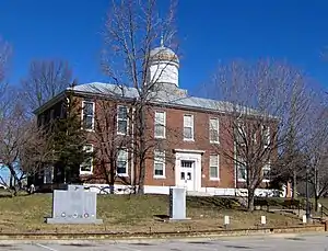 Charlotte Courthouse Square Historic District |
November 25, 1977 (#77001266) |
Public Square and environs 36°10′42″N 87°20′23″W |
Charlotte | |
| 4 | Cumberland Furnace Historic District (40DS22) | September 28, 1988 (#88001109) |
Address Restricted |
Cumberland Furnace | ||
| 5 | Dickson County War Memorial Building | 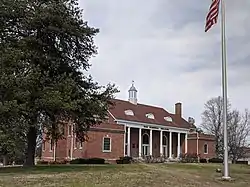 Dickson County War Memorial Building |
March 18, 1999 (#99000365) |
225 Center Ave. 36°04′27″N 87°23′26″W |
Dickson | |
| 6 | Dickson Post Office | 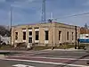 Dickson Post Office |
August 22, 1996 (#96000934) |
201 W. College St. 36°04′40″N 87°23′18″W |
Dickson | |
| 7 | Drouillard House | December 27, 1977 (#77001267) |
Off State Route 48 36°15′49″N 87°21′37″W |
Cumberland Furnace | ||
| 8 | Farmers and Merchants Bank Building | November 8, 1993 (#93001161) |
201 Main St. 36°06′18″N 87°13′13″W |
White Bluff | ||
| 9 | First National Bank of Dickson | 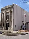 First National Bank of Dickson |
March 13, 1986 (#86000398) |
106 N. Main St. 36°04′35″N 87°23′19″W |
Dickson | |
| 10 | Halbrook Hotel | 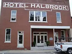 Halbrook Hotel |
June 14, 1990 (#90000915) |
100 Clement Pl. 36°04′30″N 87°23′22″W |
Dickson | |
| 11 | Jones Creek Forge (40DS30) | July 19, 1988 (#88001103) |
Address Restricted |
Harpeth Valley | ||
| 12 | Laurel Furnace (40DS4) | April 9, 1988 (#88000244) |
Address Restricted |
Burns | ||
| 13 | Leech-Larkins Farm | August 22, 1995 (#95001015) |
4199 State Route 47 36°09′50″N 87°19′27″W |
Charlotte | ||
| 14 | Lonesome | April 9, 2021 (#100006381) |
2004 TN 96 36°03′03″N 87°19′12″W |
Charlotte | ||
| 15 | Miller Family Farm | April 28, 2005 (#05000360) |
160 Old State Route 48 36°12′04″N 87°21′44″W |
Charlotte | ||
| 16 | Richard C. Napier House | July 26, 1988 (#88001110) |
Old State Route 48 36°13′15″N 87°21′55″W |
Charlotte | ||
| 17 | Neblett Place Farm | March 30, 1995 (#95000267) |
1160 St. Paul Rd. 36°11′50″N 87°18′56″W |
Charlotte | ||
| 18 | Promise Land School | 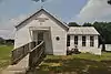 Promise Land School |
March 15, 2007 (#07000159) |
Promise Land Rd., north of Reddon Crossing/Will G Rd. 36°12′35″N 87°19′54″W |
Promise | |
| 19 | Ruskin Colony Grounds | 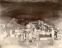 Ruskin Colony Grounds |
October 29, 1974 (#74001911) |
Northwest of Dickson on Yellow Creek Rd. 36°09′38″N 87°31′09″W |
Dickson | |
| 20 | St. James Episcopal Church | 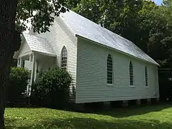 St. James Episcopal Church |
August 22, 1977 (#77001268) |
Off State Route 48 36°15′46″N 87°21′28″W |
Cumberland Furnace | |
| 21 | Upper Forge (40DS32) | September 28, 1988 (#88001097) |
Address Restricted |
Cumberland Furnace | ||
| 22 | Valley Forge (40DS28) | July 20, 1988 (#88001102) |
Address Restricted |
Charlotte | ||
| 23 | White Bluff Forge (40DS27) | September 28, 1988 (#88001104) |
Address Restricted |
White Bluff |
Former listings
| [3] | Name on the Register | Image | Date listed | Date removed | Location | City or town | Description |
|---|---|---|---|---|---|---|---|
| 1 | Peter Paul Shule Barn | May 13, 1982 (#82003967) | June 10, 2022 | Denny Rd. 36°11′25″N 87°26′56″W |
Sylvia |
See also
Wikimedia Commons has media related to National Register of Historic Places in Dickson County, Tennessee.
References
- The latitude and longitude information provided in this table was derived originally from the National Register Information System, which has been found to be fairly accurate for about 99% of listings. Some locations in this table may have been corrected to current GPS standards.
- National Park Service, United States Department of the Interior, "National Register of Historic Places: Weekly List Actions", retrieved October 20, 2023.
- Numbers represent an alphabetical ordering by significant words. Various colorings, defined here, differentiate National Historic Landmarks and historic districts from other NRHP buildings, structures, sites or objects.
- "National Register Information System". National Register of Historic Places. National Park Service. April 24, 2008.
- The eight-digit number below each date is the number assigned to each location in the National Register Information System database, which can be viewed by clicking the number.
| Topics | |
|---|---|
| Lists by state |
|
| Lists by insular areas | |
| Lists by associated state | |
| Other areas | |
| Related | |
Municipalities and communities of Dickson County, Tennessee, United States | ||
|---|---|---|
| City | ||
| Towns | ||
| Unincorporated communities | ||
This article is issued from Wikipedia. The text is licensed under Creative Commons - Attribution - Sharealike. Additional terms may apply for the media files.