National Register of Historic Places listings in Sumner County, Tennessee
This is a list of the National Register of Historic Places listings in Sumner County, Tennessee.
This is intended to be a complete list of the properties and districts on the National Register of Historic Places in Sumner County, Tennessee, United States. Latitude and longitude coordinates are provided for many National Register properties and districts; these locations may be seen together in a map.[1]
There are 38 properties and districts listed on the National Register in the county, including 1 National Historic Landmark. Another 2 properties were once listed but have been removed.
See also National Register of Historic Places listings in Davidson County, Tennessee for additional properties in Goodlettsville, a city that spans the county line.
| Anderson – Bedford – Benton – Bledsoe – Blount – Bradley – Campbell – Cannon – Carroll – Carter – Cheatham – Chester – Claiborne – Clay – Cocke – Coffee – Crockett – Cumberland – Davidson – Decatur – DeKalb – Dickson – Dyer – Fayette – Fentress – Franklin – Gibson – Giles – Grainger – Greene – Grundy – Hamblen – Hamilton – Hancock – Hardeman – Hardin – Hawkins – Haywood – Henderson – Henry – Hickman – Houston – Humphreys – Jackson – Jefferson – Johnson – Knox – Lake – Lauderdale – Lawrence – Lewis – Lincoln – Loudon – Macon – Madison – Marion – Marshall – Maury – McMinn – McNairy – Meigs – Monroe – Montgomery – Moore – Morgan – Obion – Overton – Perry – Pickett – Polk – Putnam – Rhea – Roane – Robertson – Rutherford – Scott – Sequatchie – Sevier – Shelby – Smith – Stewart – Sullivan – Sumner – Tipton – Trousdale – Unicoi – Union – Van Buren – Warren – Washington – Wayne – Weakley – White – Williamson – Wilson |
This National Park Service list is complete through NPS recent listings posted October 20, 2023.[2]
Current listings
| [3] | Name on the Register[4] | Image | Date listed[5] | Location | City or town | Description |
|---|---|---|---|---|---|---|
| 1 | Ashcrest Farm | 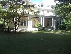 Ashcrest Farm |
April 14, 1992 (#92000349) |
410 Gallatin Rd. 36°19′12″N 86°35′29″W |
Hendersonville | |
| 2 | Bledsoe's Station | 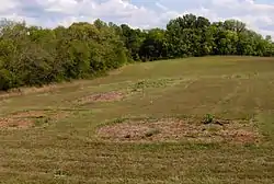 Bledsoe's Station |
July 30, 1992 (#92000970) |
Off State Route 25 west of Castalian Springs[6] 36°23′58″N 86°19′14″W |
Castalian Springs | |
| 3 | Bowen-Campbell House | 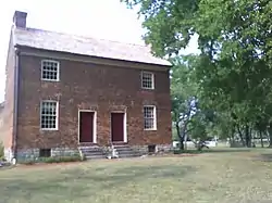 Bowen-Campbell House |
July 25, 1977 (#77001295) |
East of Goodlettsville on Jackson Rd. 36°19′19″N 86°41′22″W |
Goodlettsville | |
| 4 | Bridal House | 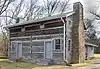 Bridal House |
February 4, 1982 (#82004059) |
Red River Rd. 36°27′04″N 86°32′18″W |
Cottontown | |
| 5 | Brown-Chenault House | Brown-Chenault House |
July 25, 1985 (#85001614) |
Chenault Lane 36°25′33″N 86°18′10″W |
Castalian Springs | |
| 6 | Cairo Rosenwald School | 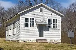 Cairo Rosenwald School |
November 15, 1996 (#96001359) |
Zieglers Fort Rd., approximately 2.5 miles (4.0 km) south of State Route 25 36°21′48″N 86°21′49″W |
Cairo | |
| 7 | Castalian Springs | .jpg.webp) Castalian Springs |
July 14, 1971 (#71000838) |
Gallatin-Hartsville Pike, State Route 25 36°23′39″N 86°18′59″W |
Castalian Springs | |
| 8 | Cragfont | 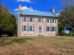 Cragfont |
February 26, 1970 (#70000618) |
East of Gallatin off State Route 25 36°24′11″N 86°20′27″W |
Gallatin | |
| 9 | Daniel Smith Donelson House | 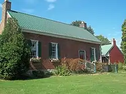 Daniel Smith Donelson House |
January 4, 1983 (#83003071) |
178 Berrywood Dr. 36°17′51″N 86°35′44″W |
Hendersonville | |
| 10 | Douglass-Clark House | 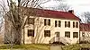 Douglass-Clark House |
March 21, 2011 (#11000098) |
Long Hollow Pike at Lower Station Camp Creek Rd. 36°22′57″N 86°33′30″W |
Gallatin vicinity | |
| 11 | Durham's Chapel School | Durham's Chapel School |
November 8, 2006 (#06000652) |
5055 Old State Route 31E 36°28′26″N 86°19′50″W |
Bethpage | |
| 12 | Mary Felice Ferrell House | Mary Felice Ferrell House |
April 14, 1992 (#92000348) |
2144 Nashville Pike 36°20′28″N 86°32′06″W |
Gallatin | |
| 13 | Leonard B. Fite House | .JPG.webp) Leonard B. Fite House |
March 25, 1982 (#82004061) |
1154 W. Main St. 36°18′38″N 86°39′43″W |
Hendersonville | |
| 14 | Gallatin Commercial Historic District | 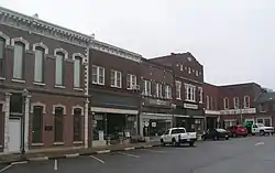 Gallatin Commercial Historic District |
October 23, 1985 (#85003369) |
Roughly bounded by Town Creek, N. Water Ave., and Boyer and College Sts., E. Main St, S. Water Ave., and Trimble St. 36°23′21″N 86°26′40″W |
Gallatin | |
| 15 | Gallatin Presbyterian Church | 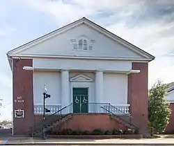 Gallatin Presbyterian Church |
March 25, 1982 (#82004060) |
167 W. Main St. 36°23′14″N 86°26′55″W |
Gallatin | |
| 16 | Greenfield | November 7, 1990 (#90001579) |
683 Rock Springs Rd. 36°26′02″N 86°19′00″W |
Castalian Springs | ||
| 17 | Hawthorne Hill | 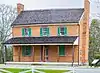 Hawthorne Hill |
June 14, 2013 (#13000401) |
470 Old Hwy 25 36°23′27″N 86°17′55″W |
Castalian Springs | |
| 18 | Hazel Path | 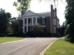 Hazel Path |
April 5, 1984 (#84003713) |
175 E. Main St. 36°18′20″N 86°36′25″W |
Hendersonville | |
| 19 | James B. Jameson House | 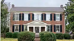 James B. Jameson House |
November 25, 1985 (#85002968) |
2458 Hartsville Pike 36°23′57″N 86°20′59″W |
Gallatin | |
| 20 | King Homestead | 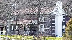 King Homestead |
January 30, 1978 (#78002640) |
West of Cottontown off State Route 25 36°27′06″N 86°34′14″W |
Cottontown | |
| 21 | Locust Grove | January 8, 1979 (#79002484) |
North of Castalian Springs 36°25′30″N 86°18′24″W |
Castalian Springs | ||
| 22 | Maple Cottage | March 15, 2000 (#00000229) |
1335 Long Hollow Pike 36°23′05″N 86°30′34″W |
Gallatin | ||
| 23 | Maple Shade | April 22, 2003 (#03000303) |
1755 State Route 31E 36°25′24″N 86°23′47″W |
Gallatin | ||
| 24 | Moye Boarding House | 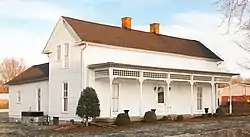 Moye Boarding House |
March 27, 2013 (#13000124) |
Northeast corner of Wheeler & N. Russell Sts. 36°34′55″N 86°30′54″W |
Portland | |
| 25 | Oakland | 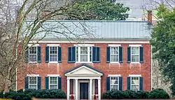 Oakland |
October 2, 1992 (#92000841) |
1995 Hartsville Pike 36°23′55″N 86°22′08″W |
Gallatin | |
| 26 | Oakley | 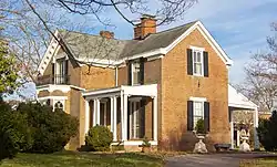 Oakley |
July 25, 1985 (#85001615) |
2243 Nashville Pike 36°21′09″N 86°30′27″W |
Gallatin | |
| 27 | Parker's Chapel Missionary Baptist Church and Cemetery | October 29, 2021 (#100007121) |
387 Airport Rd. 36°35′09″N 86°28′49″W |
Portland | ||
| 28 | Parker-Bryson Historic District | June 25, 1987 (#87001036) |
Greenfield Lane 36°25′54″N 86°19′51″W |
Castalian Springs | ||
| 29 | Rascoe-Harris Farm | July 19, 1996 (#96000772) |
1135 Liberty Ln. 36°24′24″N 86°30′42″W |
Liberty | ||
| 30 | Rock Castle | 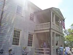 Rock Castle |
July 8, 1970 (#70000619) |
Southeast of Hendersonville on Indian Lake Rd. 36°16′45″N 86°35′47″W |
Hendersonville | |
| 31 | Rosemont | Rosemont |
April 26, 1978 (#78002641) |
810 S. Water St. 36°22′35″N 86°26′33″W |
Gallatin | |
| 32 | Shackle Island Historic District |  Shackle Island Historic District |
January 30, 1978 (#78002643) |
North of Hendersonville at Shackle Island Rd. and Long Hollow Pike 36°22′14″N 86°37′03″W |
Hendersonville | |
| 33 | Trousdale-Baskerville House | Trousdale-Baskerville House |
July 30, 2009 (#09000577) |
211 W. Smith St. 36°23′11″N 86°26′57″W |
Gallatin | |
| 34 | Trousdale Place | Trousdale Place |
June 5, 1975 (#75001793) |
183 W. Main St. 36°23′14″N 86°26′56″W |
Gallatin | |
| 35 | Wall Spring | 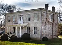 Wall Spring |
April 8, 1994 (#94000334) |
931 Red River Rd. 36°23′40″N 86°28′11″W |
Gallatin | |
| 36 | Walnut Grove | 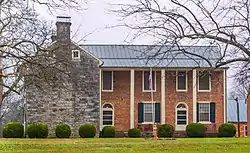 Walnut Grove |
December 29, 1978 (#78002642) |
911 Laura St. 36°23′30″N 86°28′18″W |
Gallatin | |
| 37 | Westmoreland Tunnel | 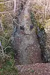 Westmoreland Tunnel |
January 20, 1978 (#78002644) |
Off State Route 52 36°33′31″N 86°14′57″W |
Westmoreland | |
| 38 | Williamson and Adams Carriage Factory | 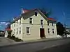 Williamson and Adams Carriage Factory |
May 12, 1987 (#87000488) |
326 E. Main St. 36°23′22″N 86°26′33″W |
Gallatin |
Former listings
| [3] | Name on the Register | Image | Date listed | Date removed | Location | City or town | Description |
|---|---|---|---|---|---|---|---|
| 1 | Fairvue | 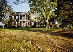 Fairvue |
June 10, 1975 (#75002162) | April 4, 2005 | 4 mi. S of Gallatin on U.S. 31E (Rozella Way below Plantation Blvd) |
Gallatin | Formerly a National Historic Landmark (note: home still exists, but it was delisted after residential development on plantation grounds) |
| 2 | Talley-Beals House | August 22, 1977 (#77001296) | June 5, 1990 | N of Hendersonville off Saunderville Rd. |
Hendersonville | House burned to the ground due to lightning strike on May 28, 1990.[7] |
See also
References
- The latitude and longitude information provided in this table was derived originally from the National Register Information System, which has been found to be fairly accurate for about 99% of listings. Some locations in this table may have been corrected to current GPS standards.
- National Park Service, United States Department of the Interior, "National Register of Historic Places: Weekly List Actions", retrieved October 20, 2023.
- Numbers represent an alphabetical ordering by significant words. Various colorings, defined here, differentiate National Historic Landmarks and historic districts from other NRHP buildings, structures, sites or objects.
- "National Register Information System". National Register of Historic Places. National Park Service. April 24, 2008.
- The eight-digit number below each date is the number assigned to each location in the National Register Information System database, which can be viewed by clicking the number.
- Location derived from this Bledsoe's Fort-related website; the NRIS lists it as "Address Restricted"
- "Fire destroys historic Hendersonville home". The Tennessean. May 29, 1990. p. 2B. Retrieved August 29, 2022 – via Newspapers.com.
| Topics | |
|---|---|
| Lists by state |
|
| Lists by insular areas | |
| Lists by associated state | |
| Other areas | |
| Related | |
Municipalities and communities of Sumner County, Tennessee, United States | ||
|---|---|---|
| Cities | Sumner County map | |
| Town | ||
| CDPs | ||
| Unincorporated communities | ||
| Footnotes | ‡This populated place also has portions in an adjacent county or counties | |