National Register of Historic Places listings in Sevier County, Tennessee
This is a list of the National Register of Historic Places listings in Sevier County, Tennessee.
Location of Sevier County in Tennessee
This is intended to be a complete list of the properties and districts on the National Register of Historic Places in Sevier County, Tennessee, United States. Latitude and longitude coordinates are provided for many National Register properties and districts; these locations may be seen together in a map.[1]
There are 38 properties and districts listed on the National Register in the county. Two properties were once listed, but have since been removed.
| Anderson – Bedford – Benton – Bledsoe – Blount – Bradley – Campbell – Cannon – Carroll – Carter – Cheatham – Chester – Claiborne – Clay – Cocke – Coffee – Crockett – Cumberland – Davidson – Decatur – DeKalb – Dickson – Dyer – Fayette – Fentress – Franklin – Gibson – Giles – Grainger – Greene – Grundy – Hamblen – Hamilton – Hancock – Hardeman – Hardin – Hawkins – Haywood – Henderson – Henry – Hickman – Houston – Humphreys – Jackson – Jefferson – Johnson – Knox – Lake – Lauderdale – Lawrence – Lewis – Lincoln – Loudon – Macon – Madison – Marion – Marshall – Maury – McMinn – McNairy – Meigs – Monroe – Montgomery – Moore – Morgan – Obion – Overton – Perry – Pickett – Polk – Putnam – Rhea – Roane – Robertson – Rutherford – Scott – Sequatchie – Sevier – Shelby – Smith – Stewart – Sullivan – Sumner – Tipton – Trousdale – Unicoi – Union – Van Buren – Warren – Washington – Wayne – Weakley – White – Williamson – Wilson |
This National Park Service list is complete through NPS recent listings posted October 20, 2023.[2]
Current listings
| [3] | Name on the Register[4] | Image | Date listed[5] | Location | City or town | Description |
|---|---|---|---|---|---|---|
| 1 | Riley H. Andes House | 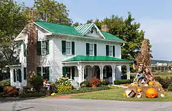 Riley H. Andes House |
July 8, 1980 (#80003854) |
812 Old Douglas Dam Rd 35°53′01″N 83°34′18″W |
Sevierville | |
| 2 | Mayna Treanor Avent Studio | 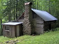 Mayna Treanor Avent Studio |
February 7, 1994 (#93001575) |
Jake's Creek Trail, 1 mile (1.6 km) south of Elkton 35°38′21″N 83°35′15″W |
Elkmont | |
| 3 | Brabson's Ferry Plantation | 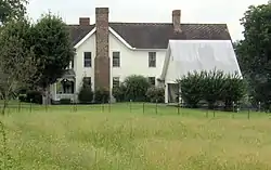 Brabson's Ferry Plantation |
June 25, 1975 (#75001780) |
1248 Indian Warpath Rd 35°55′45″N 83°39′03″W |
Sevierville | |
| 4 | Buckingham House | .jpg.webp) Buckingham House |
March 18, 1971 (#71000831) |
West of Sevierville on Sevierville Pike 35°54′58″N 83°37′56″W |
Sevierville | |
| 5 | Clingmans Dome Observation Tower | 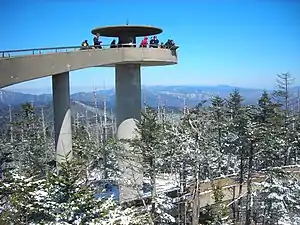 Clingmans Dome Observation Tower |
August 15, 2012 (#12000515) |
Terminus of Clingmans Dome Rd. 35°33′46″N 83°29′55″W |
Gatlinburg | also listed in Swain County, North Carolina |
| 6 | Alex Cole Cabin | 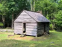 Alex Cole Cabin |
January 2, 1976 (#76000165) |
On the Roaring Fork Motor Nature Trail, 5 miles (8.0 km) south of Gatlinburg off U.S. Route 441 in Great Smoky Mountains National Park 35°39′59″N 83°31′22″W |
Gatlinburg | |
| 7 | Douglas Hydroelectric Project |  Douglas Hydroelectric Project |
August 14, 2017 (#100001475) |
850 Powerhouse Way 35°57′40″N 83°32′20″W |
Dandridge | |
| 8 | Elkmont Historic District, Great Smoky Mountains NP | 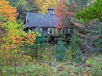 Elkmont Historic District, Great Smoky Mountains NP |
March 22, 1994 (#94000166) |
Off State Route 72 southwest of Gatlinburg 35°39′20″N 83°35′04″W |
Gatlinburg | |
| 9 | First Methodist Church, Gatlinburg | 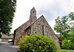 First Methodist Church, Gatlinburg |
July 3, 2007 (#07000661) |
742 Parkway 35°42′41″N 83°31′02″W |
Gatlinburg | |
| 10 | Harrisburg Covered Bridge | 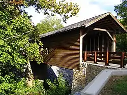 Harrisburg Covered Bridge |
June 10, 1975 (#75001777) |
South of Harrisburg off U.S. Route 411 over East Fork of the Little Pigeon River 35°51′39″N 83°28′58″W |
Harrisburg | |
| 11 | Headrick's Chapel |  Headrick's Chapel |
July 19, 2001 (#01000756) |
4327 Wears Valley Rd 35°42′00″N 83°40′47″W |
Harchertown | |
| 12 | Keener-Johnson Farm | March 18, 1999 (#99000367) |
1112 Boyd's Creek Highway 35°53′16″N 83°43′47″W |
Seymour | ||
| 13 | King-Walker Place | 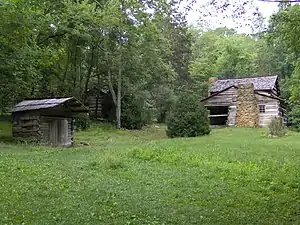 King-Walker Place |
March 16, 1976 (#76000169) |
West of Gatlinburg off State Route 73 off the Little Brier Gap Trail in Great Smoky Mountains National Park 35°41′39″N 83°37′45″W |
Gatlinburg | |
| 14 | Little Greenbrier School-Church | 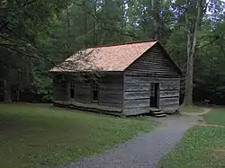 Little Greenbrier School-Church |
January 11, 1976 (#76000168) |
About 9 miles (14 km) west of Gatlinburg off State Route 73 along the Metcalf Bottoms Trail in Great Smoky Mountains National Park 35°41′01″N 83°38′17″W |
Gatlinburg | |
| 15 | Tyson McCarter Place | 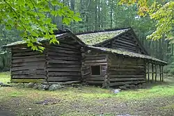 Tyson McCarter Place |
March 16, 1976 (#76000204) |
10 miles (16 km) east of Gatlinburg on State Route 73 in Great Smoky Mountains National Park 35°46′N 83°18′W |
Gatlinburg | |
| 16 | Messer Barn | 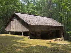 Messer Barn |
January 1, 1976 (#76000166) |
Southeast of Gatlinburg near Greenbrier Cove along the Brushy Mountain Trail in Great Smoky Mountains National Park 35°41′13″N 83°23′54″W |
Gatlinburg | |
| 17 | New Salem Baptist Church | 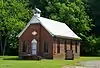 New Salem Baptist Church |
July 24, 2003 (#03000696) |
601 Eastgate Rd. 35°51′32″N 83°33′14″W |
Sevierville | Built in 1886 by African-American brick mason Isaac Dockery; part of the Rural African-American Churches in Tennessee Multiple Property Submission (MPS) |
| 18 | Bud Ogle Farm | 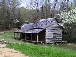 Bud Ogle Farm |
November 23, 1977 (#77000158) |
On Cherokee Orchard Rd 3 miles (4.8 km) southeast of Gatlinburg 35°40′50″N 83°29′28″W |
Gatlinburg | |
| 19 | John Ownby Cabin | 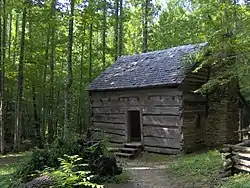 John Ownby Cabin |
January 1, 1976 (#76000167) |
On the Fighting Creek Nature Trail, 3 miles (4.8 km) south of Gatlinburg off State Route 73 in Great Smoky Mountains National Park 35°41′22″N 83°32′50″W |
Gatlinburg | |
| 20 | Perry's Camp | 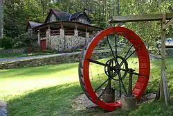 Perry's Camp |
October 30, 1992 (#92000369) |
101 Flat Branch Rd. 35°43′31″N 83°31′40″W |
Gatlinburg | |
| 21 | Pigeon Forge Mill | 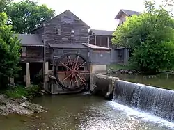 Pigeon Forge Mill |
June 10, 1975 (#75001778) |
175 Old Mill Ave 35°47′18″N 83°33′15″W |
Pigeon Forge | |
| 22 | Pittman Community Center Home Economics Building | 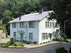 Pittman Community Center Home Economics Building |
November 29, 1996 (#96001406) |
2839 Webb Creek Rd. 35°45′30″N 83°23′44″W |
Pittman Center | |
| 23 | Roaring Fork Historic District | 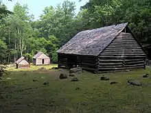 Roaring Fork Historic District |
March 16, 1976 (#76000170) |
5 miles (8.0 km) southeast of Gatlinburg off State Route 73 in Great Smoky Mountains National Park 35°41′54″N 83°28′04″W |
Gatlinburg | |
| 24 | Rocky Springs Presbyterian Church | December 18, 2013 (#13000953) |
2656 Boyds Creek Hwy. 35°55′23″N 83°39′43″W |
Sevierville vicinity | ||
| 25 | Rose Glen | 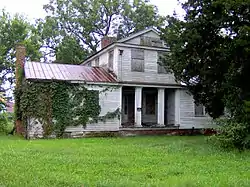 Rose Glen |
July 18, 1975 (#75001781) |
4 miles (6.4 km) east of Sevierville on the Newport Highway 35°51′34″N 83°29′58″W |
Sevierville | |
| 26 | Settlement School Community Outreach Historic District | 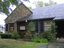 Settlement School Community Outreach Historic District |
July 11, 2007 (#07000686) |
556 Parkway 35°42′46″N 83°30′45″W |
Gatlinburg | Comprises publicly accessible parts of the campus of the settlement school established by Pi Beta Phi that now houses the Arrowmont School of Arts and Crafts.[6] Part of the Pi Beta Phi Settlement School MPS |
| 27 | Settlement School Dormitories and Dwellings Historic District | 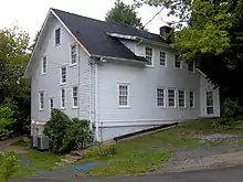 Settlement School Dormitories and Dwellings Historic District |
March 20, 2007 (#07000185) |
556 Parkway 35°42′45″N 83°30′37″W |
Gatlinburg | Comprises residential portions of the campus of the settlement school established by Pi Beta Phi that now houses the Arrowmont School of Arts and Crafts.[7] Part of the Pi Beta Phi Settlement School MPS |
| 28 | Sevier County Courthouse | 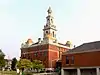 Sevier County Courthouse |
March 24, 1971 (#71000832) |
Court Ave. 35°52′04″N 83°33′58″W |
Sevierville | |
| 29 | Sevierville Commercial Historic District |  Sevierville Commercial Historic District |
October 23, 1986 (#86002910) |
Sections of Bruce St., Court Ave., and Commerce St. 35°52′05″N 83°33′57″W |
Sevierville | |
| 30 | Shults Grove Methodist Church | 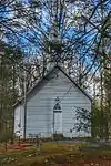 Shults Grove Methodist Church |
November 22, 2016 (#16000790) |
505 Balls Hollow Rd E 35°47′02″N 83°17′47″W |
Cosby | |
| 31 | Thomas Addition Historic District | March 17, 1994 (#94000197) |
Roughly bounded by Park Rd., Belle Ave., Cedar St., Grace Ave., and Prince St. 35°51′39″N 83°33′38″W |
Sevierville | ||
| 32 | Trotter-McMahan House | October 10, 1975 (#75001783) |
1848 Middle Creek Rd • Boundary increase (listed November 21, 2001, refnum 01001262): 1605 Middle Creek Rd. 35°49′49″N 83°32′22″W |
Sevierville | ||
| 33 | US Post Office-Sevierville | 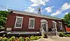 US Post Office-Sevierville |
March 14, 1997 (#97000240) |
167 Bruce St. 35°52′01″N 83°33′51″W |
Sevierville | |
| 34 | Dwight and Kate Wade House | 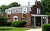 Dwight and Kate Wade House |
December 15, 1997 (#97001502) |
114 Joy St. 35°51′59″N 83°33′55″W |
Sevierville | Built in 1940 by Fred McMahan, designed by New York architect Verna Cook Salomonsky |
| 35 | Walker Mill Hydroelectric Station | 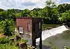 Walker Mill Hydroelectric Station |
November 20, 1990 (#90001751) |
West Prong of the Little Pigeon River just off U.S. Route 441 35°50′44″N 83°34′08″W |
Sevierville | part of the Pre-TVA Hydroelectric Power Development in Tennessee MPS |
| 36 | Waters House | 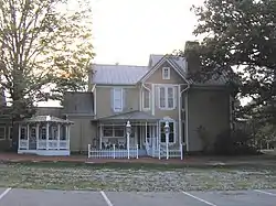 Waters House |
June 18, 1975 (#75001784) |
217 Cedar St. 35°51′56″N 83°33′46″W |
Sevierville | |
| 37 | Wheatlands | 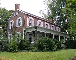 Wheatlands |
July 7, 1975 (#75001785) |
2507 TN-338 35°55′07″N 83°40′06″W |
Sevierville |
Former listings
| [3] | Name on the Register | Image | Date listed | Date removed | Location | City or town | Description |
|---|---|---|---|---|---|---|---|
| 1 | Mountain View Hotel | September 13, 1984 (#84003681) | December 13, 1999 | 400 Parkway |
Gatlinburg | Demolished in March and April, 1993.[8] | |
| 2 | Sevierville Masonic Lodge | February 7, 1980 (#80003855) | April 12, 2022 | 119 Main St. 35°52′06″N 83°33′50″W |
Sevierville | Demolished in 2006 for a parking lot.[9] |
See also
Wikimedia Commons has media related to National Register of Historic Places in Sevier County, Tennessee.
References
- The latitude and longitude information provided in this table was derived originally from the National Register Information System, which has been found to be fairly accurate for about 99% of listings. Some locations in this table may have been corrected to current GPS standards.
- National Park Service, United States Department of the Interior, "National Register of Historic Places: Weekly List Actions", retrieved October 20, 2023.
- Numbers represent an alphabetical ordering by significant words. Various colorings, defined here, differentiate National Historic Landmarks and historic districts from other NRHP buildings, structures, sites or objects.
- "National Register Information System". National Register of Historic Places. National Park Service. April 24, 2008.
- The eight-digit number below each date is the number assigned to each location in the National Register Information System database, which can be viewed by clicking the number.
- http://www.state.tn.us/environment/hist/pdf/settlement_cohd.pdf
- http://www.state.tn.us/environment/hist/pdf/settlement&dwellings.pdf
- "Piece of Gatlinburg history a memory with Mountain View Hotel demolition". The Knoxville News Sentinel. April 7, 1993. p. S1. Retrieved August 29, 2022 – via Newspapers.com.
- "NRHP continuation sheet" (PDF). tn.gov.
| Topics | |
|---|---|
| Lists by state |
|
| Lists by insular areas | |
| Lists by associated state | |
| Other areas | |
| Related | |
Municipalities and communities of Sevier County, Tennessee, United States | ||
|---|---|---|
| Cities | Sevier County map | |
| Town | ||
| CDPs | ||
| Other communities | ||
| Footnotes | ‡This populated place also has portions in an adjacent county or counties | |
This article is issued from Wikipedia. The text is licensed under Creative Commons - Attribution - Sharealike. Additional terms may apply for the media files.