Armbouts-Cappel
Armbouts-Cappel (French pronunciation: [aʁmbuts kapɛl]; from Dutch: Armboutskappel) is a commune in the Nord department in northern France.[3]
Armbouts-Cappel
Armboutskappel | |
|---|---|
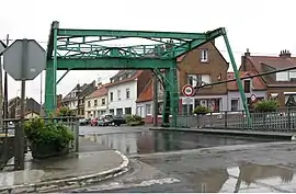 The bridge in Grand-Millebrugghe | |
 Coat of arms | |
Location of Armbouts-Cappel | |
 Armbouts-Cappel  Armbouts-Cappel | |
| Coordinates: 50°58′42″N 2°21′15″E | |
| Country | France |
| Region | Hauts-de-France |
| Department | Nord |
| Arrondissement | Dunkerque |
| Canton | Coudekerque-Branche |
| Intercommunality | CU de Dunkerque |
| Government | |
| • Mayor (2020–2026) | Jean-Luc Darcourt[1] |
| Area 1 | 10.15 km2 (3.92 sq mi) |
| Population | 2,159 |
| • Density | 210/km2 (550/sq mi) |
| Time zone | UTC+01:00 (CET) |
| • Summer (DST) | UTC+02:00 (CEST) |
| INSEE/Postal code | 59016 /59380 |
| Elevation | 0–6 m (0–20 ft) (avg. 2 m or 6.6 ft) |
| 1 French Land Register data, which excludes lakes, ponds, glaciers > 1 km2 (0.386 sq mi or 247 acres) and river estuaries. | |
It is 7 kilometers south of the centre of Dunkirk.
Population
|
|
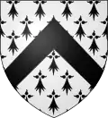
Heraldry
Arms of Armbouts-Cappel |
The arms of Armbouts-Cappel are blazoned : Ermine, a chevron sable.
|
See also
References
- "Répertoire national des élus: les maires". data.gouv.fr, Plateforme ouverte des données publiques françaises (in French). 2 December 2020.
- "Populations légales 2020". The National Institute of Statistics and Economic Studies. 29 December 2022.
- INSEE commune file
Wikimedia Commons has media related to Armbouts-Cappel.
This article is issued from Wikipedia. The text is licensed under Creative Commons - Attribution - Sharealike. Additional terms may apply for the media files.