Boeschepe
Boeschepe (French pronunciation: [bɔskɛp]) is a commune in the Nord department in northern France, next to the Belgian border.[3]
Boeschepe | |
|---|---|
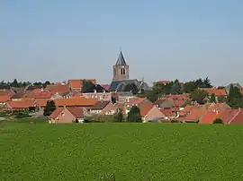 A general view of Boeschepe | |
_Nord-France.svg.png.webp) Coat of arms | |
Location of Boeschepe | |
 Boeschepe  Boeschepe | |
| Coordinates: 50°48′01″N 2°41′31″E | |
| Country | France |
| Region | Hauts-de-France |
| Department | Nord |
| Arrondissement | Dunkerque |
| Canton | Bailleul |
| Intercommunality | CC Flandre Intérieure |
| Government | |
| • Mayor (2020–2026) | Luc Van Inghelandt[1] |
| Area 1 | 13.59 km2 (5.25 sq mi) |
| Population | 2,144 |
| • Density | 160/km2 (410/sq mi) |
| Time zone | UTC+01:00 (CET) |
| • Summer (DST) | UTC+02:00 (CEST) |
| INSEE/Postal code | 59086 /59299 |
| Elevation | 28–153 m (92–502 ft) (avg. 74 m or 243 ft) |
| 1 French Land Register data, which excludes lakes, ponds, glaciers > 1 km2 (0.386 sq mi or 247 acres) and river estuaries. | |
Population
|
|
Heraldry
Arms of Boeschepe |
The arms of Boeschepe are blazoned : Or, 3 chevrons sable. (Bersillies, Boeschepe, Boussières-sur-Sambre, Colleret, Cousolre, Flaumont-Waudrechies, Hautmont, Limont-Fontaine, Lompret, Masny, Neuville-en-Avesnois and Saint-Rémy-du-Nord use the same arms.)
|
See also
References
- "Répertoire national des élus: les maires". data.gouv.fr, Plateforme ouverte des données publiques françaises (in French). 9 August 2021.
- "Populations légales 2020". The National Institute of Statistics and Economic Studies. 29 December 2022.
- INSEE commune file
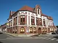 Town hall
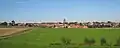 View of Boeschepe from the south
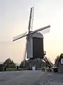 The Ondankmeulen (unthankfullness windmill)
Wikimedia Commons has media related to Boeschepe.
This article is issued from Wikipedia. The text is licensed under Creative Commons - Attribution - Sharealike. Additional terms may apply for the media files.