Ferrière-la-Grande
Ferrière-la-Grande (French pronunciation: [fɛʁjɛʁ la ɡʁɑ̃d]) is a commune in the Nord department in northern France.[3] The river Solre flows through the commune.
Ferrière-la-Grande | |
|---|---|
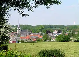 Global view | |
.svg.png.webp) Coat of arms | |
Location of Ferrière-la-Grande | |
 Ferrière-la-Grande  Ferrière-la-Grande | |
| Coordinates: 50°15′20″N 3°59′36″E | |
| Country | France |
| Region | Hauts-de-France |
| Department | Nord |
| Arrondissement | Avesnes-sur-Helpe |
| Canton | Maubeuge |
| Intercommunality | CA Maubeuge Val de Sambre |
| Government | |
| • Mayor (2020–2026) | Benoît Courtin[1] |
| Area 1 | 10.01 km2 (3.86 sq mi) |
| Population | 5,239 |
| • Density | 520/km2 (1,400/sq mi) |
| Time zone | UTC+01:00 (CET) |
| • Summer (DST) | UTC+02:00 (CEST) |
| INSEE/Postal code | 59230 /59680 |
| Elevation | 127–184 m (417–604 ft) (avg. 149 m or 489 ft) |
| 1 French Land Register data, which excludes lakes, ponds, glaciers > 1 km2 (0.386 sq mi or 247 acres) and river estuaries. | |
In 1828 Pierre François Dumont applied for a concession to operate iron mines in the canton of Maubeuge, and for authorization to establish two iron furnaces at Ferrière-la-Grande powered by steam.[4] Dumont founded the factories at Ferrière-la-grande in 1830, the first coke-fired blast furnaces in the north of France to produce and mould pig-iron from the local minerals.[5] By decree of 23 April 1859 Dumont was granted a concession to build a railway line to link the factories Ferrière-la-Grande to the Saint-Quentin line at Erquelinnes. The line was built on land acquired by Dumont or expropriated on the grounds of public utility.[6]
Population
| Year | Pop. | ±% p.a. |
|---|---|---|
| 1968 | 5,346 | — |
| 1975 | 5,703 | +0.93% |
| 1982 | 5,611 | −0.23% |
| 1990 | 5,746 | +0.30% |
| 1999 | 5,672 | −0.14% |
| 2007 | 5,457 | −0.48% |
| 2012 | 5,365 | −0.34% |
| 2017 | 5,301 | −0.24% |
| Source: INSEE[7] | ||
Heraldry
.svg.png.webp) Arms of Ferrière-la-Grande |
The arms of Ferrière-la-Grande are blazoned : Quarterly 1&4: Argent, 3 fesses gules; 2&3: Argent, 3 wagoner's axes top 2 addorsed gules. [8](Bermerain, Étrœungt, Féron, Ferrière-la-Grande, Lez-Fontaine, Rousies, Solre-le-Château and Solrinnes use the same arms.)
|
See also
References
- "Répertoire national des élus: les maires" (in French). data.gouv.fr, Plateforme ouverte des données publiques françaises. 13 September 2022.
- "Populations légales 2020". The National Institute of Statistics and Economic Studies. 29 December 2022.
- INSEE commune file
- Barbier & Daviet 1989, p. 217.
- Bulletin de le Societe ... 1890, p. 265.
- Carnot 1881, p. 367.
- Population en historique depuis 1968, INSEE
- Arms of the families of Croÿ-Solre and Croÿ-Renty quartered
Sources
- Barbier, Frédéric; Daviet, Jean-Pierre (1989), Le patronat du Nord sous le Second Empire: une approche prosopographique, Librairie Droz, ISBN 978-2-600-03408-1, retrieved 19 August 2017
- "Etablissements metallurgiques de Ferrière-la-grande", Bulletin de le Societe de l'Industrie Minerale (in French), vol. IV, Société de l'industrie minérale, 1890, retrieved 28 October 2017
- Carnot, Sadi (1881), Annales des ponts et chaussees. 2. partie: Partie administrative (in French), retrieved 28 October 2017