Bambecque
Bambecque (French pronunciation: [bɑ̃bɛk]; Dutch: Bambeke) is a commune in the Nord department in northern France.[3]
Bambecque
Bambeke | |
|---|---|
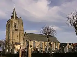 The church in Bambecque | |
_Nord.svg.png.webp) Coat of arms | |
Location of Bambecque | |
 Bambecque  Bambecque | |
| Coordinates: 50°54′05″N 2°32′55″E | |
| Country | France |
| Region | Hauts-de-France |
| Department | Nord |
| Arrondissement | Dunkerque |
| Canton | Wormhout |
| Intercommunality | Hauts de Flandre |
| Government | |
| • Mayor (2020–2026) | Grégoire Francke[1] |
| Area 1 | 11.81 km2 (4.56 sq mi) |
| Population | 822 |
| • Density | 70/km2 (180/sq mi) |
| Time zone | UTC+01:00 (CET) |
| • Summer (DST) | UTC+02:00 (CEST) |
| INSEE/Postal code | 59046 /59470 |
| Elevation | 2–24 m (6.6–78.7 ft) (avg. 8 m or 26 ft) |
| 1 French Land Register data, which excludes lakes, ponds, glaciers > 1 km2 (0.386 sq mi or 247 acres) and river estuaries. | |
Etymology
Bambecque has historically been attested as Banbeca in 1164. The toponym Bambecque is of Germanic origin, deriving from a Low German dialect, ultimately from Proto-West-Germanic *ban. Within the Nord and Pas-de-Calais departments, the Germanic hydronym *-bak(i) entered the French language via Low German, and took on two forms: the Germanic form -beek and Romance -becque (also -bec, -becques).[4]
Population
|
|
Heraldry
Arms of Bambecque |
The arms of Bambecque are blazoned : Argent, a lion sable, armed and langued gules. (The arms of Bambecque, Crochte, Killem and Maing are essentially the same)
|
Points of interest
See also
References
- "Répertoire national des élus: les maires". data.gouv.fr, Plateforme ouverte des données publiques françaises (in French). 2 December 2020.
- "Populations légales 2020". The National Institute of Statistics and Economic Studies. 29 December 2022.
- INSEE commune file
- Caljouw, William Robert (1981). Germanic elements in French Toponymy (Thesis). University of British Columbia. pp. 148, 151. doi:10.14288/1.0094985. Retrieved 12 January 2021.
Wikimedia Commons has media related to Bambecque.
This article is issued from Wikipedia. The text is licensed under Creative Commons - Attribution - Sharealike. Additional terms may apply for the media files.