Carnières
Carnières (French pronunciation: [kaʁnjɛʁ]) is a commune in the Nord department in northern France.[3]
Carnières | |
|---|---|
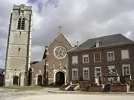 The centre of Carnières | |
 Coat of arms | |
Location of Carnières | |
 Carnières  Carnières | |
| Coordinates: 50°10′07″N 3°20′51″E | |
| Country | France |
| Region | Hauts-de-France |
| Department | Nord |
| Arrondissement | Cambrai |
| Canton | Caudry |
| Intercommunality | CA Caudrésis–Catésis |
| Government | |
| • Mayor (2020–2026) | Sandrine Hotton[1] |
| Area 1 | 8.13 km2 (3.14 sq mi) |
| Population | 1,009 |
| • Density | 120/km2 (320/sq mi) |
| Time zone | UTC+01:00 (CET) |
| • Summer (DST) | UTC+02:00 (CEST) |
| INSEE/Postal code | 59132 /59217 |
| Elevation | 58–104 m (190–341 ft) (avg. 80 m or 260 ft) |
| 1 French Land Register data, which excludes lakes, ponds, glaciers > 1 km2 (0.386 sq mi or 247 acres) and river estuaries. | |
It is about 7 km (4.3 mi) east of Cambrai.
Heraldry
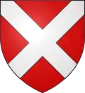
Arms of Carnières |
The arms of Carnières are blazoned : Gules, a saltire argent.
|
See also
References
- "Répertoire national des élus: les maires" (in French). data.gouv.fr, Plateforme ouverte des données publiques françaises. 13 September 2022.
- "Populations légales 2020". The National Institute of Statistics and Economic Studies. 29 December 2022.
- INSEE commune file
Wikimedia Commons has media related to Carnières (Nord).
This article is issued from Wikipedia. The text is licensed under Creative Commons - Attribution - Sharealike. Additional terms may apply for the media files.