Arnèke
Arnèke (French pronunciation: [aʁnɛk]; French Flemish: Arnyke; Dutch: Arneke) is a commune in the Nord department in northern France.[3]
Arnèke
| |
|---|---|
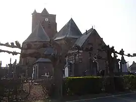 Saint Martin | |
_Nord-France.svg.png.webp) Coat of arms | |
Location of Arnèke | |
 Arnèke  Arnèke | |
| Coordinates: 50°49′53″N 2°24′43″E | |
| Country | France |
| Region | Hauts-de-France |
| Department | Nord |
| Arrondissement | Dunkerque |
| Canton | Wormhout |
| Intercommunality | Flandre Intérieure |
| Government | |
| • Mayor (2020–2026) | Francis Ampen[1] |
| Area 1 | 13.41 km2 (5.18 sq mi) |
| Population | 1,566 |
| • Density | 120/km2 (300/sq mi) |
| Time zone | UTC+01:00 (CET) |
| • Summer (DST) | UTC+02:00 (CEST) |
| INSEE/Postal code | 59018 /59285 |
| Elevation | 14–50 m (46–164 ft) (avg. 25 m or 82 ft) |
| 1 French Land Register data, which excludes lakes, ponds, glaciers > 1 km2 (0.386 sq mi or 247 acres) and river estuaries. | |
Geography
Arnèke is situated on the D55 (route de Wormhout). The small river Peene Becque is flowing through the village. The village eastern limit with Ledringhem is voie romaine (D52) and southern limit is Peene Becque.
Population
|
|
Heraldry
Arms of Arnèke |
The arms of Arnèke are blazoned : Sable, on a cross argent, 5 ermine spots sable.
|
Transportation

Arneke train station
A train station is serving the village.
See also
References
- "Répertoire national des élus: les maires". data.gouv.fr, Plateforme ouverte des données publiques françaises (in French). 2 December 2020.
- "Populations légales 2020". The National Institute of Statistics and Economic Studies. 29 December 2022.
- INSEE commune file
Wikimedia Commons has media related to Arnèke.
This article is issued from Wikipedia. The text is licensed under Creative Commons - Attribution - Sharealike. Additional terms may apply for the media files.