Cléguérec
Cléguérec (French pronunciation: [kleɡeʁɛk]; Breton: Klegereg) is a commune in the Morbihan department of Brittany in north-western France.[3]
Cléguérec
Klegereg | |
|---|---|
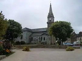 The parish church Saint Guérec. | |
.svg.png.webp) Coat of arms | |
Location of Cléguérec | |
 Cléguérec  Cléguérec | |
| Coordinates: 48°07′30″N 3°04′10″W | |
| Country | France |
| Region | Brittany |
| Department | Morbihan |
| Arrondissement | Pontivy |
| Canton | Gourin |
| Intercommunality | Pontivy Communauté |
| Government | |
| • Mayor (2020–2026) | Marc Ropers[1] |
| Area 1 | 62.99 km2 (24.32 sq mi) |
| Population | 2,835 |
| • Density | 45/km2 (120/sq mi) |
| Time zone | UTC+01:00 (CET) |
| • Summer (DST) | UTC+02:00 (CEST) |
| INSEE/Postal code | 56041 /56480 |
| Elevation | 55–281 m (180–922 ft) |
| 1 French Land Register data, which excludes lakes, ponds, glaciers > 1 km2 (0.386 sq mi or 247 acres) and river estuaries. | |
Geography
The town is located 12 km (7.5 mi) northwest of Pontivy. Cléguérec is border by Séglien and Silfiac to the west, by Sainte-Brigitte and Saint-Aignan to the north, by Neulliac to the east and by Malguénac to the south. Historically, the town belongs to Vanetais. The forest of Quénécan extends to the north of the commune. The Breuil du Chêne is the highest hill in the town. The summit is 948 feet (289 m) above sea level.
Map

Demographics
Inhabitants of Cléguérec are called in French Cléguérecois.
|
| |||||||||||||||||||||||||||||||||||||||||||||||||||||||||||||||||||||||||||||||||||||||||||||||||||||||||||||||||||||
| Source: EHESS[4] and INSEE (1968-2020)[5][6] | ||||||||||||||||||||||||||||||||||||||||||||||||||||||||||||||||||||||||||||||||||||||||||||||||||||||||||||||||||||||
Breton language
In 2008, 13,85% of children in the commune attended bilingual primary schools.[7]
Gallery
 Manor of Corbello
_7844.JPG.webp) Chapel of Trinity
Chapel of Trinity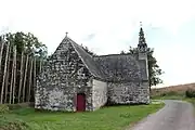 Chapel Saint-André de Langlo
 Gallery grave of Bot-er-Mohed
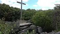 Calvary on the top of Breuil du Chêne
See also
- Communes of the Morbihan department
- Gaston-Auguste Schweitzer Sculptor of Cléguérec war memorial
References
- "Maires du Morbihan" (PDF). Préfecture du Morbihan. 7 July 2020.
- "Populations légales 2020". The National Institute of Statistics and Economic Studies. 29 December 2022.
- INSEE commune file
- Des villages de Cassini aux communes d'aujourd'hui: Commune data sheet Cléguérec, EHESS (in French).
- Population en historique depuis 1968, INSEE
- Populations légales 2020, INSEE
- (in French) Ofis ar Brezhoneg: Enseignement bilingue
External links
Wikimedia Commons has media related to Cléguérec.
- Official site (in French)
- Base Mérimée: Search for heritage in the commune, Ministère français de la Culture. (in French)
- Mayors of Morbihan Association (in French)
This article is issued from Wikipedia. The text is licensed under Creative Commons - Attribution - Sharealike. Additional terms may apply for the media files.