Le Saint
Le Saint (French pronunciation: [lə sɛ̃]; Breton: Ar Sent) is a commune in the Morbihan department of Brittany in north-western France.[3]
Le Saint
Ar Sent | |
|---|---|
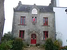 The town hall in Le Saint | |
.svg.png.webp) Coat of arms | |
Location of Le Saint | |
 Le Saint  Le Saint | |
| Coordinates: 48°05′25″N 3°33′40″W | |
| Country | France |
| Region | Brittany |
| Department | Morbihan |
| Arrondissement | Pontivy |
| Canton | Gourin |
| Intercommunality | Roi Morvan Communauté |
| Government | |
| • Mayor (2020–2026) | Jérôme Regnier[1] |
| Area 1 | 31.03 km2 (11.98 sq mi) |
| Population | 590 |
| • Density | 19/km2 (49/sq mi) |
| Time zone | UTC+01:00 (CET) |
| • Summer (DST) | UTC+02:00 (CEST) |
| INSEE/Postal code | 56201 /56110 |
| Elevation | 73–223 m (240–732 ft) |
| 1 French Land Register data, which excludes lakes, ponds, glaciers > 1 km2 (0.386 sq mi or 247 acres) and river estuaries. | |
Breton language
The municipality launched a Breton linguistic plan through Ya d'ar brezhoneg on 24 February 2005.
Population
The population has been divided by three since the first world war.
|
| |||||||||||||||||||||||||||||||||||||||||||||||||||||||||||||||||||||||||||||||||||||||||||||||||||||||||||||||||||||
| Source: EHESS[4] and INSEE (1968-2020)[5][6] | ||||||||||||||||||||||||||||||||||||||||||||||||||||||||||||||||||||||||||||||||||||||||||||||||||||||||||||||||||||||
Geography
Le Saint is located in the northwestern part of Morbihan, 40 km (25 mi) north of Lorient. Historically, it belongs to Cornouaille. Le Saint is border by Gourin to the west and the north, by Langonnet and Le Faouët to the east and by Guiscriff to the south. The river Inam forms the commune's western border and the river Moulin du Duc forms the commune's eastern border. The two rivers meet at the southern end of the commune at a place called Pont Briand. Apart from the village centre there are about eighty hamlets.
Map

List of places
|
|
|
|
|
History
The lords of Faouët, the Bouteville, lived in their castle in Le Saint in the fifteenth century.

Gallery
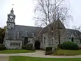 The church.
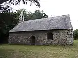 The chapel of Saint-Méen.
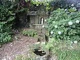 Fountain of Saint-Méen.
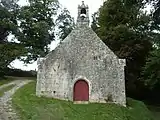 The chapel of Saint-Trémeur.
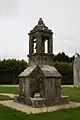 Oratory of Bouthiry.
See also
References
- "Maires du Morbihan" (PDF). Préfecture du Morbihan. 7 July 2020.
- "Populations légales 2020". The National Institute of Statistics and Economic Studies. 29 December 2022.
- INSEE commune file
- Des villages de Cassini aux communes d'aujourd'hui: Commune data sheet Le Saint, EHESS (in French).
- Population en historique depuis 1968, INSEE
- Populations légales 2020, INSEE
External links
- Base Mérimée: Search for heritage in the commune, Ministère français de la Culture. (in French)
- Mayors of Morbihan Association (in French)