Séglien
Séglien (French pronunciation: [seɡlijɛ̃]; Breton: Seglian) is a commune in the Morbihan department of Brittany in north-western France.[3]
Séglien
Seglian | |
|---|---|
 The parish church in Séglien | |
Location of Séglien | |
 Séglien  Séglien | |
| Coordinates: 48°06′28″N 3°09′30″W | |
| Country | France |
| Region | Brittany |
| Department | Morbihan |
| Arrondissement | Pontivy |
| Canton | Gourin |
| Intercommunality | Pontivy Communauté |
| Government | |
| • Mayor (2020–2026) | Laurent Ganivet[1] |
| Area 1 | 38.36 km2 (14.81 sq mi) |
| Population | 645 |
| • Density | 17/km2 (44/sq mi) |
| Time zone | UTC+01:00 (CET) |
| • Summer (DST) | UTC+02:00 (CEST) |
| INSEE/Postal code | 56242 /56160 |
| Elevation | 123–248 m (404–814 ft) |
| 1 French Land Register data, which excludes lakes, ponds, glaciers > 1 km2 (0.386 sq mi or 247 acres) and river estuaries. | |
Demographics
Inhabitants of Séglien are called in French Ségliennais.
|
| |||||||||||||||||||||||||||||||||||||||||||||||||||||||||||||||||||||||||||||||||||||||||||||||||||||||||||||||||||||
| Source: EHESS[4] and INSEE (1968-2020)[5][6] | ||||||||||||||||||||||||||||||||||||||||||||||||||||||||||||||||||||||||||||||||||||||||||||||||||||||||||||||||||||||
Geography
Séglien is border by Silfiac to the north, by Langoëlan to the west, by Locmalo and Guern to the south and by Malguénac and Cléguérec to the east. Historically, Séglien belongs to Vannetais. The river Sarre, a tributary of the river Blavet, flows through the commune.
Map

History
From the roman period there remains a section of the roman road connecting Castennec to Carhaix, passing through Mané-Guégan, Quénécalec and Resterhierven. On this road, no far from Saint-Germain, there is a mutilated cylindrical stone, which could habe been a milestone.[7]
Gallery
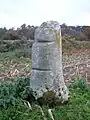 Mutilated cylindrical stone on the ancient roman road, maybe ancient milestone.
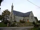 Chapel Saint Germain.
 Bread oven in Saint Germain.
_7896.JPG.webp) Chapel of Locmaria.
Chapel of Locmaria.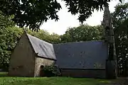 Chapel Saint John.
See also
References
- "Maires du Morbihan" (PDF). Préfecture du Morbihan. 7 July 2020.
- "Populations légales 2020". The National Institute of Statistics and Economic Studies. 29 December 2022.
- INSEE commune file
- Des villages de Cassini aux communes d'aujourd'hui: Commune data sheet Séglien, EHESS (in French).
- Population en historique depuis 1968, INSEE
- Populations légales 2020, INSEE
- Histoire des paroisses du Diocèse de Vannes, J-M Le Méné, 1891
External links
Wikimedia Commons has media related to Séglien.
- Official website (in French)
- Base Mérimée: Search for heritage in the commune, Ministère français de la Culture. (in French)
- Mayors of Morbihan Association (in French)
This article is issued from Wikipedia. The text is licensed under Creative Commons - Attribution - Sharealike. Additional terms may apply for the media files.