Peillac
Peillac (French pronunciation: [pɛjak] ⓘ; Breton: Paolieg; Gallo: Peilla) is a commune in the east of Morbihan department of Brittany in north-western France.[3]
Peillac
Paolieg | |
|---|---|
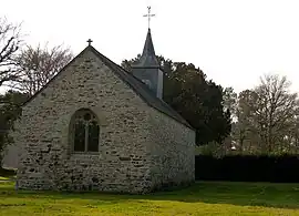 The chapel of Saint-Julien | |
.svg.png.webp) Coat of arms | |
Location of Peillac | |
 Peillac  Peillac | |
| Coordinates: 47°42′51″N 2°13′05″W | |
| Country | France |
| Region | Brittany |
| Department | Morbihan |
| Arrondissement | Vannes |
| Canton | Guer |
| Intercommunality | Redon Agglomération |
| Government | |
| • Mayor (2020–2026) | Philippe Jegou[1] |
| Area 1 | 24.57 km2 (9.49 sq mi) |
| Population | 1,840 |
| • Density | 75/km2 (190/sq mi) |
| Time zone | UTC+01:00 (CET) |
| • Summer (DST) | UTC+02:00 (CEST) |
| INSEE/Postal code | 56154 /56220 |
| Elevation | 0–82 m (0–269 ft) |
| 1 French Land Register data, which excludes lakes, ponds, glaciers > 1 km2 (0.386 sq mi or 247 acres) and river estuaries. | |
Geography
The canal de Nantes à Brest forms all of the commune's northern border; the river Arz forms all of its southern border.
Demographics
Inhabitants of Peillac are called in French Peillacois.
|
| ||||||||||||||||||||||||||||||||||||||||||||||||||||||||||||||||||||||||||||||||||||||||||||||||||||||||||||||||||||||||||||||||||||
Map

See also
References
- "Maires du Morbihan" (PDF). Préfecture du Morbihan. 7 July 2020.
- "Populations légales 2020". The National Institute of Statistics and Economic Studies. 29 December 2022.
- INSEE commune file
External links
- Mayors of Morbihan Association (in French)
Wikimedia Commons has media related to Peillac.
This article is issued from Wikipedia. The text is licensed under Creative Commons - Attribution - Sharealike. Additional terms may apply for the media files.