Cerisy-Belle-Étoile
Cerisy-Belle-Étoile is a commune in the Orne department in north-western France.
Cerisy-Belle-Étoile | |
|---|---|
 The ruins of the chateau in Cerisy | |
Location of Cerisy-Belle-Étoile | |
 Cerisy-Belle-Étoile  Cerisy-Belle-Étoile | |
| Coordinates: 48°47′54″N 0°37′31″W | |
| Country | France |
| Region | Normandy |
| Department | Orne |
| Arrondissement | Argentan |
| Canton | Flers-1 |
| Intercommunality | CA Flers Agglo |
| Government | |
| • Mayor (2020–2026) | Hervé Borderie[1] |
| Area 1 | 13.40 km2 (5.17 sq mi) |
| Population | 713 |
| • Density | 53/km2 (140/sq mi) |
| Demonym | Ceriséens ou Estoliens |
| Time zone | UTC+01:00 (CET) |
| • Summer (DST) | UTC+02:00 (CEST) |
| INSEE/Postal code | 61078 /61100 |
| Elevation | 102–256 m (335–840 ft) |
| 1 French Land Register data, which excludes lakes, ponds, glaciers > 1 km2 (0.386 sq mi or 247 acres) and river estuaries. | |
Geography
The commune is part of the area known as Norman Switzerland.[3]
The commune is made up of the following collection of villages and hamlets: La Monnerie, La Perrière, La Morlandière, La Vallerie, La Jehannière, Les Haies, Les Loges, La Gaumonnière, L'Abbaye de Belle Étoile, La Hagrie, Épivent, Visance and Cerisy-Belle-Étoile.[4]
The commune is traversed by the Noireau and Visance rivers, as well as the Fontaines stream.[5]
Neighbouring communes[4] | |
|---|---|
Notable buildings and places
National heritage sites
- The former Abbey of Belle-Etoile is a thirteenth century former abbey established after the conquest of Normandy by Philip II of France. It was made a Monument historique in 1926.[8]
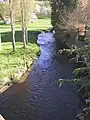 Noireau River in Cerisy-Belle-Étoile
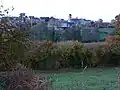 Le Bourg in Cerisy-Belle-Etoile
 Abbaye de Belle-Étoile
People linked with the commune
- Étienne de Veniard, Sieur de Bourgmont (1679 – 1734), a French explorer who documented his travels across North America was born here.[9]
See also
References
- "Répertoire national des élus: les maires". data.gouv.fr, Plateforme ouverte des données publiques françaises (in French). 9 August 2021.
- "Populations légales 2020". The National Institute of Statistics and Economic Studies. 29 December 2022.
- "Map of Suiss Normande" (PDF).
- "Cerisy-Belle-Étoile · 61100, France". Cerisy-Belle-Étoile · 61100, France.
- "Mairie de Cerisy-Belle-Étoile et sa commune (61100)". Annuaire-Mairie. 27 April 2023.
- "Les forêts".
- "Forêt communale de Cerisy-Belle-Etoile - Se balader à Cerisy-Belle-Étoile". www.annuaire-mairie.fr.
- "Ancienne abbaye de Belle-Etoile à Cerisy-Belle-Etoile - PA00110762". monumentum.fr.
- "Etienne Veniard de Bourgmont - Kansapedia - Kansas Historical Society". www.kshs.org.
Wikimedia Commons has media related to Cerisy-Belle-Étoile.
This article is issued from Wikipedia. The text is licensed under Creative Commons - Attribution - Sharealike. Additional terms may apply for the media files.