Champcerie
Champcerie (French pronunciation: [ʃɑ̃səʁi] ⓘ) is a commune in the Orne department in north-western France.
Champcerie | |
|---|---|
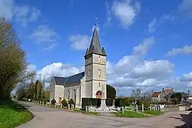 The church in Champcerie | |
Location of Champcerie | |
 Champcerie  Champcerie | |
| Coordinates: 48°48′39″N 0°13′26″W | |
| Country | France |
| Region | Normandy |
| Department | Orne |
| Arrondissement | Argentan |
| Canton | Athis-Val de Rouvre |
| Intercommunality | Val d'Orne |
| Government | |
| • Mayor (2020–2026) | Dominique Pichonnier[1] |
| Area 1 | 8.94 km2 (3.45 sq mi) |
| Population | 175 |
| • Density | 20/km2 (51/sq mi) |
| Time zone | UTC+01:00 (CET) |
| • Summer (DST) | UTC+02:00 (CEST) |
| INSEE/Postal code | 61084 /61210 |
| Elevation | 159–231 m (522–758 ft) |
| 1 French Land Register data, which excludes lakes, ponds, glaciers > 1 km2 (0.386 sq mi or 247 acres) and river estuaries. | |
Geography
The commune of Champcerie is part of the area known as Suisse Normande.[3]
The commune is made up of the following collection of villages and hamlets, Champcerie, Fumeçon and La Chardinière.
The river Baize runs through the commune, along with two of its tributaries, Ruisseau de la Fontaine Andre and Ruisseau des Vallees.[4][5][6] In addition you have the Ruisseau des Monts Hiboux which is a tributary to the Orne.[7]
Neighbouring communes[8] | |
|---|---|
Notable buildings and places
The Commune contains a Renaissance period house has been listed as Monument historique as the main interest lies in the quality and refinement of its interior decor, as very little has been altered since the origin.[9]
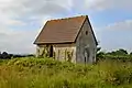 Chapelle of Notre-Dame-des-Victoires in Champcerie
See also
References
- "Répertoire national des élus: les maires". data.gouv.fr, Plateforme ouverte des données publiques françaises (in French). 2 December 2020.
- "Populations légales 2020". The National Institute of Statistics and Economic Studies. 29 December 2022.
- "Map of Suiss Normande" (PDF).
- Sandre. "Fiche cours d'eau - La Baize (I22-0400)".
- "Ruisseau des Vallees (61-2), Cours d'eau en France". www.annuaire-mairie.fr.
- "Ruisseau de la Fontaine Andre, Cours d'eau en France". www.annuaire-mairie.fr.
- "Ruisseau des Monts Hiboux, Cours d'eau en France". www.annuaire-mairie.fr.
- "ViaMichelin: Route planner, Maps, Traffic info, Hotels". www.viamichelin.co.uk.
- "Maison Renaissance à Champcerie - PA00110981 - Monumentum".
Wikimedia Commons has media related to Champcerie.
This article is issued from Wikipedia. The text is licensed under Creative Commons - Attribution - Sharealike. Additional terms may apply for the media files.