Froberville
Froberville is a commune in the Seine-Maritime department in the Normandy region in northern France.
Froberville | |
|---|---|
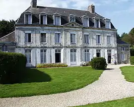 The chateau in Froberville | |
 Coat of arms | |
Location of Froberville | |
 Froberville  Froberville | |
| Coordinates: 49°43′21″N 0°19′56″E | |
| Country | France |
| Region | Normandy |
| Department | Seine-Maritime |
| Arrondissement | Le Havre |
| Canton | Fécamp |
| Intercommunality | CA Fécamp Caux Littoral |
| Area 1 | 5.88 km2 (2.27 sq mi) |
| Population | 1,168 |
| • Density | 200/km2 (510/sq mi) |
| Time zone | UTC+01:00 (CET) |
| • Summer (DST) | UTC+02:00 (CEST) |
| INSEE/Postal code | 76291 /76400 |
| Elevation | 56–112 m (184–367 ft) (avg. 91 m or 299 ft) |
| 1 French Land Register data, which excludes lakes, ponds, glaciers > 1 km2 (0.386 sq mi or 247 acres) and river estuaries. | |
Geography
A farming village situated in the Pays de Caux, some 21 miles (34 km) northeast of Le Havre, at the junction of the D940 and D279 roads.
Heraldry
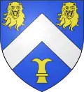
Arms of Froberville |
The arms of Froberville are blazoned : Azure, a chevron argent between 2 leopard's heads affronty (erased) and a chess rook Or.
|
Population
| Year | Pop. | ±% p.a. |
|---|---|---|
| 1968 | 358 | — |
| 1975 | 459 | +3.61% |
| 1982 | 619 | +4.36% |
| 1990 | 732 | +2.12% |
| 1999 | 810 | +1.13% |
| 2007 | 1,052 | +3.32% |
| 2012 | 1,086 | +0.64% |
| 2017 | 1,245 | +2.77% |
| Source: INSEE[2] | ||
Places of interest
- The church of St.Hélène, dating from the nineteenth century.
- The Château d'Hainneville
- The fourteenth century chapel of St. Eloi.
References
External links
Wikimedia Commons has media related to Froberville.
This article is issued from Wikipedia. The text is licensed under Creative Commons - Attribution - Sharealike. Additional terms may apply for the media files.