Turretot
Turretot (French pronunciation: [tyʁto]) is a commune in the Seine-Maritime department in the Normandy region in northern France.
Turretot | |
|---|---|
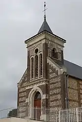 The church in Turretot | |
.svg.png.webp) Coat of arms | |
Location of Turretot | |
 Turretot  Turretot | |
| Coordinates: 49°36′29″N 0°13′41″E | |
| Country | France |
| Region | Normandy |
| Department | Seine-Maritime |
| Arrondissement | Le Havre |
| Canton | Octeville-sur-Mer |
| Intercommunality | Le Havre Seine Métropole |
| Government | |
| • Mayor (2020–2026) | Thérèse Baril[1] |
| Area 1 | 6.07 km2 (2.34 sq mi) |
| Population | 1,505 |
| • Density | 250/km2 (640/sq mi) |
| Time zone | UTC+01:00 (CET) |
| • Summer (DST) | UTC+02:00 (CEST) |
| INSEE/Postal code | 76716 /76280 |
| Elevation | 70–122 m (230–400 ft) (avg. 104 m or 341 ft) |
| 1 French Land Register data, which excludes lakes, ponds, glaciers > 1 km2 (0.386 sq mi or 247 acres) and river estuaries. | |
Geography
A farming village in the Pays de Caux, situated some 12 miles (19 km) northeast of Le Havre, at the junction of the D78 and D125e roads.
Population
| Year | Pop. | ±% p.a. |
|---|---|---|
| 1968 | 284 | — |
| 1975 | 587 | +10.93% |
| 1982 | 1,157 | +10.18% |
| 1990 | 1,178 | +0.23% |
| 1999 | 1,315 | +1.23% |
| 2007 | 1,442 | +1.16% |
| 2012 | 1,511 | +0.94% |
| 2017 | 1,469 | −0.56% |
| Source: INSEE[3] | ||
Places of interest
- The church of St. Anne, dating from the thirteenth century.
- The church of St. Martin, dating from the twelfth century.
References
- Liste des maires du département de la Seine-Maritime, 10 August 2020
- "Populations légales 2020". The National Institute of Statistics and Economic Studies. 29 December 2022.
- Population en historique depuis 1968, INSEE
External links
Wikimedia Commons has media related to Turretot.
- Website of the Sporting Club de Turretot (in French)
This article is issued from Wikipedia. The text is licensed under Creative Commons - Attribution - Sharealike. Additional terms may apply for the media files.