Virville
Virville (French pronunciation: [viʁvil]) is a commune in the Seine-Maritime department in the Normandy region in northern France.
Virville | |
|---|---|
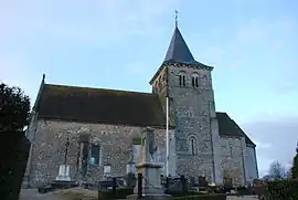 The church in Virville | |
Location of Virville | |
 Virville  Virville | |
| Coordinates: 49°35′33″N 0°21′21″E | |
| Country | France |
| Region | Normandy |
| Department | Seine-Maritime |
| Arrondissement | Le Havre |
| Canton | Saint-Romain-de-Colbosc |
| Intercommunality | CC Campagne de Caux |
| Government | |
| • Mayor (2020–2026) | Emmanuelle Schuft[1] |
| Area 1 | 2.46 km2 (0.95 sq mi) |
| Population | 348 |
| • Density | 140/km2 (370/sq mi) |
| Time zone | UTC+01:00 (CET) |
| • Summer (DST) | UTC+02:00 (CEST) |
| INSEE/Postal code | 76747 /76110 |
| Elevation | 93–127 m (305–417 ft) (avg. 120 m or 390 ft) |
| 1 French Land Register data, which excludes lakes, ponds, glaciers > 1 km2 (0.386 sq mi or 247 acres) and river estuaries. | |
Geography
A small farming village in the Pays de Caux, situated some 13 miles (21 km) northeast of Le Havre, at the junction of the D125 and D10 roads. An SNCF TER railway station serves both this and a neighbouring commune.
Population
| Year | Pop. | ±% p.a. |
|---|---|---|
| 1968 | 147 | — |
| 1975 | 155 | +0.76% |
| 1982 | 211 | +4.50% |
| 1990 | 254 | +2.35% |
| 1999 | 260 | +0.26% |
| 2007 | 303 | +1.93% |
| 2012 | 360 | +3.51% |
| 2017 | 357 | −0.17% |
| Source: INSEE[3] | ||
Places of interest
- The church of St. Aubin, dating from the twelfth century.
References
- "Répertoire national des élus: les maires" (in French). data.gouv.fr, Plateforme ouverte des données publiques françaises. 13 September 2022.
- "Populations légales 2020". The National Institute of Statistics and Economic Studies. 29 December 2022.
- Population en historique depuis 1968, INSEE
Wikimedia Commons has media related to Virville.
This article is issued from Wikipedia. The text is licensed under Creative Commons - Attribution - Sharealike. Additional terms may apply for the media files.