Lanquetot
Lanquetot (French pronunciation: [lɑ̃kto]) is a commune in the Seine-Maritime department in the Normandy region in northern France.
Lanquetot | |
|---|---|
 Coat of arms | |
Location of Lanquetot | |
 Lanquetot  Lanquetot | |
| Coordinates: 49°35′09″N 0°31′34″E | |
| Country | France |
| Region | Normandy |
| Department | Seine-Maritime |
| Arrondissement | Le Havre |
| Canton | Bolbec |
| Intercommunality | Caux Seine Agglo |
| Government | |
| • Mayor (2020–2026) | Roger Bergougnoux[1] |
| Area 1 | 5.09 km2 (1.97 sq mi) |
| Population | 1,156 |
| • Density | 230/km2 (590/sq mi) |
| Time zone | UTC+01:00 (CET) |
| • Summer (DST) | UTC+02:00 (CEST) |
| INSEE/Postal code | 76382 /76210 |
| Elevation | 73–149 m (240–489 ft) (avg. 142 m or 466 ft) |
| 1 French Land Register data, which excludes lakes, ponds, glaciers > 1 km2 (0.386 sq mi or 247 acres) and river estuaries. | |
Geography
A farming village in the Pays de Caux, some 19 miles (31 km) northeast of Le Havre, at the junction of the D9015, D30 and D109 roads.
Heraldry
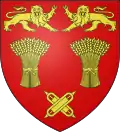
Arms of Lanquetot |
The arms of Lanquetot are blazoned : Gules, in fess 2 garbs between 2 leopards respectant and 2 weaver's shuttles in saltire Or.
|
Population
| Year | Pop. | ±% p.a. |
|---|---|---|
| 1968 | 824 | — |
| 1975 | 907 | +1.38% |
| 1982 | 1,063 | +2.29% |
| 1990 | 1,000 | −0.76% |
| 1999 | 1,004 | +0.04% |
| 2007 | 1,009 | +0.06% |
| 2012 | 1,059 | +0.97% |
| 2017 | 1,147 | +1.61% |
| Source: INSEE[3] | ||
Places of interest
- The church of St. Aubin, dating from the eleventh century.
References
- Liste des maires du département de la Seine-Maritime, 10 August 2020
- "Populations légales 2020". The National Institute of Statistics and Economic Studies. 29 December 2022.
- Population en historique depuis 1968, INSEE
Wikimedia Commons has media related to Lanquetot.
This article is issued from Wikipedia. The text is licensed under Creative Commons - Attribution - Sharealike. Additional terms may apply for the media files.