List of listed buildings in Auchterarder, Perth and Kinross
List
| Name | Location | Date Listed | Grid Ref. [note 1] | Geo-coordinates | Notes | LB Number [note 2] | Image |
|---|---|---|---|---|---|---|---|
| Girnal House, High Street | 56°17′48″N 3°42′24″W | Category B | 21338 |  Upload Photo | |||
| Golf Hotel, 138 High Street | 56°17′44″N 3°42′28″W | Category C(S) | 21348 | Upload Photo | |||
| 200-206 High Street | 56°17′41″N 3°42′40″W | Category B | 21349 | Upload Photo | |||
| St. Kattan's Chapel Aberuthven | 56°19′02″N 3°39′41″W | Category B | 5818 | Upload Photo | |||
| St. Kattan's Churchyard Aberuthven (Old Part Only) | 56°19′01″N 3°39′40″W | Category B | 5820 | Upload Photo | |||
| Old Parish Church Tower And Graveyard | 56°17′49″N 3°42′23″W | Category B | 21336 | Upload Photo | |||
| 36 And 38 High Street | 56°17′50″N 3°42′11″W | Category C(S) | 21346 | Upload Photo | |||
| The Doo'Cot At 10 The Doocot, Coll Earn Castle Estate | 56°17′56″N 3°42′07″W | Category B | 21360 | Upload Photo | |||
| Barony Parish Church, High Street | 56°17′51″N 3°42′03″W | Category B | 21342 | Upload Photo | |||
| 76 Feus | 56°17′54″N 3°41′58″W | Category C(S) | 21352 | Upload Photo | |||
| Ruthven Tower Hotel, Abbey Hill | 56°17′53″N 3°41′47″W | Category B | 21357 | Upload Photo | |||
| Strathearn Home Institution | 56°17′05″N 3°43′38″W | Category C(S) | 5811 | Upload Photo | |||
| Foswell | 56°16′42″N 3°40′42″W | Category B | 5817 | Upload Photo | |||
| Craiginver Aberuthven (Former Free Manse) | 56°19′15″N 3°39′04″W | Category C(S) | 5823 | Upload Photo | |||
| St. Andrews And West Church, High Street | 56°17′50″N 3°42′08″W | Category B | 21343 | Upload Photo | |||
| 34 High Street | 56°17′50″N 3°42′10″W | Category C(S) | 21345 | Upload Photo | |||
| Drumcharry, Montrose Road | 56°17′47″N 3°42′15″W | Category B | 21356 | Upload Photo | |||
| Auchterarder House Stables | 56°18′49″N 3°41′49″W | Category B | 5814 | Upload Photo | |||
| Smiddy Haugh Inn And Two Adjoining Houses Aberuthven | 56°19′10″N 3°39′13″W | Category C(S) | 5822 | Upload Photo | |||
| Masonic Hall, 85-89 High Street | 56°17′48″N 3°42′22″W | Category B | 21339 | Upload Photo | |||
| St. Kessog's Episcopal Church Off High Street | 56°17′46″N 3°42′39″W | Category C(S) | 21350 | Upload Photo | |||
| St. Margaret's Hospital, Townhead | 56°17′37″N 3°43′09″W | Category B | 21354 | Upload Photo | |||
| Rosewell Cottage Aberuthven | 56°19′07″N 3°39′27″W | Category C(S) | 5821 | Upload Photo | |||
| Drumtogle Mill | 56°19′40″N 3°38′58″W | Category C(S) | 5824 | Upload Photo | |||
| Aytoun Hall, High Street | 56°17′48″N 3°42′24″W | Category C(S) | 21337 | 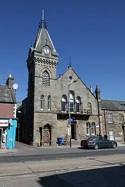
| |||
| Coll-Earn Castle Hotel, Hunter Street And High Street | 56°17′59″N 3°42′12″W | Category B | 21358 | Upload Photo | |||
| Auchterarder House | 56°18′43″N 3°41′55″W | Category B | 5813 | Upload Photo | |||
| House Of Coul | 56°17′38″N 3°40′09″W | Category C(S) | 5815 | Upload Photo | |||
| Eaglesview, Upper Borland Park | 56°17′36″N 3°43′26″W | Category C(S) | 5825 | Upload Photo | |||
| Mansefield, High Street | 56°17′49″N 3°42′06″W | Category B | 21344 | Upload Photo | |||
| The Priory, Crown Wynd | 56°17′42″N 3°42′21″W | Category C(S) | 21355 | Upload Photo | |||
| Coll-Earn Lodge, Hunter Street | 56°18′02″N 3°42′05″W | Category B | 21359 | Upload Photo | |||
| Auchterarder House, West Lodge And Gates | 56°18′45″N 3°42′07″W | Category B | 5812 | Upload Photo | |||
| Cloan | 56°17′07″N 3°40′40″W | Category B | 5816 | 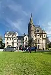
| |||
| 65 And 67 High Street | 56°17′49″N 3°42′19″W | Category B | 21340 | Upload Photo | |||
| Railway Hotel, 1 High Street | 56°17′54″N 3°42′01″W | Category B | 21341 | Upload Photo | |||
| 86, 88 And 90 High Street | 56°17′47″N 3°42′21″W | Category C(S) | 21347 | Upload Photo | |||
| 70 And 72 Feus | 56°17′54″N 3°41′56″W | Category C(S) | 21351 | Upload Photo | |||
| St. Mackessog's Church And Churchyard | 56°18′26″N 3°42′07″W | Category B | 5810 | Upload Photo | |||
| Montrose Mausoleum St. Kattan's Churchyard Aberuthven | 56°19′02″N 3°39′40″W | Category A | 5819 | 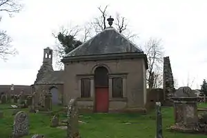
| |||
| Pairney Bridge (Disused) Off B 8062 | 56°17′56″N 3°39′41″W | Category B | 5826 | Upload Photo |
Key
The scheme for classifying buildings in Scotland is:
- Category A: "buildings of national or international importance, either architectural or historic; or fine, little-altered examples of some particular period, style or building type."[1]
- Category B: "buildings of regional or more than local importance; or major examples of some particular period, style or building type, which may have been altered."[1]
- Category C: "buildings of local importance; lesser examples of any period, style, or building type, as originally constructed or moderately altered; and simple traditional buildings which group well with other listed buildings."[1]
In March 2016 there were 47,288 listed buildings in Scotland. Of these, 8% were Category A, and 50% were Category B, with the remaining 42% being Category C.[2]
Notes
- Sometimes known as OSGB36, the grid reference (where provided) is based on the British national grid reference system used by the Ordnance Survey.
• "Guide to National Grid". Ordnance Survey. Retrieved 12 December 2007.
• "Get-a-map". Ordnance Survey. Retrieved 17 December 2007. - Historic Environment Scotland assign a unique alphanumeric identifier to each designated site in Scotland, for listed buildings this always begins with "LB", for example "LB12345".
References
- All entries, addresses and coordinates are based on data from Historic Scotland. This data falls under the Open Government Licence
- "What is Listing?". Historic Environment Scotland. Retrieved 29 May 2018.
- Scotland's Historic Environment Audit 2016 (PDF). Historic Environment Scotland and the Built Environment Forum Scotland. pp. 15–16. Retrieved 29 May 2018.
This article is issued from Wikipedia. The text is licensed under Creative Commons - Attribution - Sharealike. Additional terms may apply for the media files.