List of listed buildings in Fortingall, Perth and Kinross
List
| Name | Location | Date Listed | Grid Ref. [note 1] | Geo-coordinates | Notes | LB Number [note 2] | Image |
|---|---|---|---|---|---|---|---|
| Dunalastair | 56°42′13″N 4°06′28″W | Category B | 44621 |  Upload Photo | |||
| Glenlyon House - Farmhouse | 56°35′55″N 4°03′38″W | Category B | 13811 | Upload Photo | |||
| War Memorial Churchyard Gate | 56°35′53″N 4°03′04″W | Category C(S) | 12290 | Upload Photo | |||
| St. Blane's Chapel, Lassintullich Graveyard | 56°41′35″N 4°07′54″W | Category C(S) | 12233 | Upload Photo | |||
| East Tempar, Farmhouse | 56°41′28″N 4°08′19″W | Category C(S) | 12234 | Upload Photo | |||
| Glenlyon House With Surrounding Walls And Gates Etc | 56°35′55″N 4°03′40″W | Category B | 12266 | Upload Photo | |||
| Bridge Of Lyon | 56°35′40″N 4°04′23″W | Category B | 12269 | Upload Photo | |||
| Artrasgairt, Centre Group | 56°36′01″N 4°04′11″W | Category C(S) | 12271 | Upload Photo | |||
| Bridge Of Balgie, Over River Lyon | 56°35′28″N 4°19′09″W | Category B | 12281 | Upload Photo | |||
| Kinloch Rannoch Bridge Over River Tummel | 56°42′00″N 4°11′12″W | Category B | 12283 | Upload Photo | |||
| Loch Rannoch, Killichonan, Grianan | 56°41′25″N 4°22′24″W | Category B | 51749 | Upload Photo | |||
| Fortingal Parish Church | 56°35′53″N 4°03′02″W | Category B | 12288 | 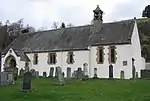
| |||
| Fortingal Churchyard | 56°35′53″N 4°03′03″W | Category C(S) | 12289 | Upload Photo | |||
| Mr Menzies Fortingal | 56°35′54″N 4°03′11″W | Category C(S) | 12294 | Upload Photo | |||
| St. Blane's Chapel, Lassintullich Cross-Slab At S.W. Corner Of Grave-Yard | 56°41′35″N 4°07′54″W | Category B | 12232 | Upload Photo | |||
| Aulich Bridge Over Allt A Chreagain Odhair | 56°42′08″N 4°16′18″W | Category C(S) | 12237 | Upload Photo | |||
| Village Hall, Fortingal | 56°35′54″N 4°03′25″W | Category B | 12261 | Upload Photo | |||
| Carnbane Castle | 56°36′15″N 4°09′24″W | Category B | 12276 | Upload Photo | |||
| Glenlyon - Innerwick Church Of Scotland | 56°35′54″N 4°18′05″W | Category B | 12279 | Upload Photo | |||
| Old Rannoch Church Of Scotland, Kinloch Rannoch | 56°41′55″N 4°11′06″W | Category C(S) | 12282 | Upload Photo | |||
| Bunrannoch House | 56°41′39″N 4°10′44″W | Category C(S) | 12284 | Upload Photo | |||
| Fortingall, Garth, Gentian House | 56°36′21″N 4°01′34″W | Category C(S) | 50777 | Upload Photo | |||
| Grampian Hydro Electric Scheme, Rannoch Power Station | 56°41′35″N 4°24′07″W | Category A | 51716 | Upload Photo | |||
| Meggernie Castle | 56°35′02″N 4°21′22″W | Category A | 13812 | Upload Photo | |||
| Kirkton Cottages | 56°35′54″N 4°03′10″W | Category B | 12293 | Upload Photo | |||
| Chemical Cottage | 56°42′18″N 4°14′03″W | Category C(S) | 12235 | Upload Photo | |||
| Rannoch Lodge | 56°41′02″N 4°26′21″W | Category B | 12239 | Upload Photo | |||
| Rannoch Station, Including Portrait Plaque Of J H Renton | 56°41′09″N 4°34′37″W | Category B | 12245 | 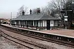
| |||
| Bridge Over Allt Odhar | 56°35′51″N 4°03′34″W | Category C(S) | 12265 | Upload Photo | |||
| Garth Castle | 56°37′44″N 4°00′59″W | Category B | 12274 | Upload Photo | |||
| Invervar, Burial Ground | 56°36′30″N 4°10′06″W | Category C(S) | 12277 | Upload Photo | |||
| Grampian Hydro Electric Scheme, Rannoch Valve-House | 56°42′02″N 4°24′12″W | Category B | 51717 | Upload Photo | |||
| Fortingal Manse | 56°35′53″N 4°03′00″W | Category C(S) | 12291 | Upload Photo | |||
| The New Cottages | 56°35′54″N 4°03′16″W | Category B | 12296 | Upload Photo | |||
| Fortingal Churchyard, Fortingal Yew And Stewart Of Garth Burial Enclosure | 56°35′54″N 4°03′03″W | Category C(S) | 12423 | Upload Photo | |||
| Crossmount | 56°41′44″N 4°06′54″W | Category B | 12231 | Upload Photo | |||
| Chemical Cottage Outbuilding | 56°42′18″N 4°14′00″W | Category C(S) | 12236 | Upload Photo | |||
| Lyon View And Post Office, Fortingal | 56°35′54″N 4°03′19″W | Category C(S) | 12259 | Upload Photo | |||
| Fendoch, Fortingal | 56°35′54″N 4°03′21″W | Category C(S) | 12260 | Upload Photo | |||
| Balnald, Duncan Mcgregor | 56°35′54″N 4°03′33″W | Category C(S) | 12264 | Upload Photo | |||
| Glenlyon House - Steading | 56°35′56″N 4°03′39″W | Category B | 12267 | Upload Photo | |||
| Glenlyon House - Laundry And Garages | 56°35′56″N 4°03′41″W | Category C(S) | 12268 | Upload Photo | |||
| Artrasgairt, East Group | 56°36′01″N 4°04′10″W | Category C(S) | 12272 | Upload Photo | |||
| Dunalastair - East Lodge | 56°42′27″N 4°04′51″W | Category B | 13813 | Upload Photo | |||
| Fortingal Hotel | 56°35′53″N 4°03′06″W | Category B | 12292 | Upload Photo | |||
| Menzies View And Mr Todd Kirkton Cottage Fortingal | 56°35′54″N 4°03′13″W | Category B | 12295 | Upload Photo | |||
| Eilean Nam Faoileag, Loch Rannoch, Tower | 56°41′16″N 4°24′03″W | Category B | 12241 | Upload Photo | |||
| Bridge Of Gaur, Or Victoria Bridge | 56°40′40″N 4°26′53″W | Category B | 12242 | Upload Photo | |||
| Invervar, Old Lint Mill | 56°36′25″N 4°10′34″W | Category B | 12278 | Upload Photo | |||
| Limekiln Near Creagan Na Leacainn | 56°42′56″N 4°06′27″W | Category C(S) | 12285 | Upload Photo | |||
| St. Blane's Chapel, Lassintullich | 56°41′35″N 4°07′55″W | Category B | 13810 | Upload Photo | |||
| Balnald Sawmill | 56°35′55″N 4°03′35″W | Category C(S) | 12263 | Upload Photo | |||
| Burial Ground Near Kerrowmore (Brenudh) | 56°35′29″N 4°18′40″W | Category B | 12280 | Upload Photo | |||
| Burial Place Of Chiefs Of Clan Donnachaidh, Dunalastair | 56°42′08″N 4°06′44″W | Category C(S) | 12286 | Upload Photo | |||
| Braes Of Rannoch Parish Church | 56°40′39″N 4°26′17″W | Category B | 12243 | Upload Photo | |||
| Balnald | 56°35′55″N 4°03′32″W | Category B | 12262 | Upload Photo | |||
| Tummel, Garry Hydro Electric Scheme, Errochty Power Station, Including Boundary Wall | 56°42′33″N 4°00′23″W | Category B | 51718 | Upload Photo | |||
| Graveyard, Killichonan | 56°41′31″N 4°22′42″W | Category C(S) | 12238 | Upload Photo | |||
| Rannoch Lodge Sundial | 56°41′01″N 4°26′26″W | Category B | 12240 | Upload Photo | |||
| Rannoch School, Dall House | 56°40′46″N 4°17′49″W | Category B | 12244 | Upload Photo | |||
| Culdaremore | 56°35′49″N 4°04′26″W | Category B | 12270 | Upload Photo | |||
| Garth House (Youth Hostel) | 56°36′17″N 4°01′32″W | Category B | 12273 | Upload Photo | |||
| Keltneyburn | 56°37′03″N 3°59′59″W | Category B | 12275 | Upload Photo |
Key
The scheme for classifying buildings in Scotland is:
- Category A: "buildings of national or international importance, either architectural or historic; or fine, little-altered examples of some particular period, style or building type."[1]
- Category B: "buildings of regional or more than local importance; or major examples of some particular period, style or building type, which may have been altered."[1]
- Category C: "buildings of local importance; lesser examples of any period, style, or building type, as originally constructed or moderately altered; and simple traditional buildings which group well with other listed buildings."[1]
In March 2016 there were 47,288 listed buildings in Scotland. Of these, 8% were Category A, and 50% were Category B, with the remaining 42% being Category C.[2]
Notes
- Sometimes known as OSGB36, the grid reference (where provided) is based on the British national grid reference system used by the Ordnance Survey.
• "Guide to National Grid". Ordnance Survey. Retrieved 12 December 2007.
• "Get-a-map". Ordnance Survey. Retrieved 17 December 2007. - Historic Environment Scotland assign a unique alphanumeric identifier to each designated site in Scotland, for listed buildings this always begins with "LB", for example "LB12345".
References
- All entries, addresses and coordinates are based on data from Historic Scotland. This data falls under the Open Government Licence
- "What is Listing?". Historic Environment Scotland. Retrieved 29 May 2018.
- Scotland's Historic Environment Audit 2016 (PDF). Historic Environment Scotland and the Built Environment Forum Scotland. pp. 15–16. Retrieved 29 May 2018.
This article is issued from Wikipedia. The text is licensed under Creative Commons - Attribution - Sharealike. Additional terms may apply for the media files.