List of listed buildings in Scone, Perth and Kinross
List
| Name | Location | Date Listed | Grid Ref. [note 1] | Geo-coordinates | Notes | LB Number [note 2] | Image |
|---|---|---|---|---|---|---|---|
| Scone Palace, Old Scone mercat cross | 56°25′26″N 3°26′06″W | Category A | 19876 | 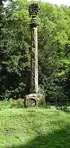
| |||
| Cross Of New Scone Junction Of Cross Street And Abbey Road, New Scone | 56°24′56″N 3°24′21″W | Category B | 18362 |  Upload Photo | |||
| 11 Mansfield Road, New Scone | 56°25′12″N 3°24′03″W | Category C(S) | 18367 | Upload Photo | |||
| Scone Palace Including Terraces | 56°25′21″N 3°26′17″W | Category A | 18370 | 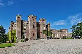
| |||
| Scone Palace Mortuary Chapel Or Mausoleum. Boot (Or Moot) Hill | 56°25′25″N 3°26′16″W | Category A | 18371 | 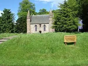
| |||
| Scone Palace, Queen's Bridge Over Catmoor Burn | 56°25′14″N 3°25′56″W | Category B | 18375 | Upload Photo | |||
| Bonhard House | 56°24′57″N 3°22′55″W | Category B | 18381 | Upload Photo | |||
| Colen, Steading | 56°27′26″N 3°26′51″W | Category B | 18384 | Upload Photo | |||
| Waulkmill Ferry Bothy | 56°26′42″N 3°27′01″W | Category B | 18974 | Upload Photo | |||
| Hill House | 56°27′26″N 3°27′09″W | Category C(S) | 18356 | Upload Photo | |||
| Mediaeval Coffin And Other Fragments | 56°25′22″N 3°26′13″W | Category B | 18373 | Upload Photo | |||
| Scone Palace Stables | 56°25′27″N 3°26′13″W | Category B | 18376 | Upload Photo | |||
| Balboughty Steading | 56°25′56″N 3°25′17″W | Category B | 18377 | Upload Photo | |||
| Blairhall, Farmhouse | 56°26′22″N 3°26′07″W | Category B | 18379 | Upload Photo | |||
| Scone New Church Perth Road, New Scone | 56°25′13″N 3°23′53″W | Category B | 18363 | Upload Photo | |||
| 19 Lynedoch Road, New Scone | 56°25′24″N 3°24′01″W | Category B | 18369 | Upload Photo | |||
| Balboughty House | 56°25′56″N 3°25′08″W | Category C(S) | 18378 | Upload Photo | |||
| Newmiln Cottages | 56°27′25″N 3°24′38″W | Category C(S) | 48739 | Upload Photo | |||
| Parish Church, New Scone | 56°24′52″N 3°24′30″W | Category B | 18361 | Upload Photo | |||
| New Scone, Abbey Road, Robert Douglas Memorial Institute (Former School) And 22 Mansfield Road | 56°25′14″N 3°24′07″W | Category B | 18365 | Upload Photo | |||
| Scone Palace, Gateway And Boundary Wall Of Old Place | 56°25′25″N 3°26′08″W | Category B | 18372 | Upload Photo | |||
| Newmiln, Gateway | 56°27′26″N 3°24′53″W | Category C(S) | 18357 | Upload Photo | |||
| Fairfield | 56°27′23″N 3°24′32″W | Category B | 19875 | Upload Photo | |||
| Scone New Church Hall, Abbey Road, New Scone | 56°25′11″N 3°24′10″W | Category C(S) | 18364 | Upload Photo | |||
| St. David's Chapel Stormontfield | 56°27′07″N 3°26′53″W | Category B | 18382 | 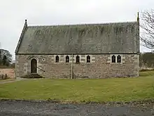
| |||
| Colen, Farmhouse | 56°27′24″N 3°26′51″W | Category B | 18383 | Upload Photo | |||
| 12 Mansfield Road, New Scone | 56°25′13″N 3°24′00″W | Category C(S) | 18366 | Upload Photo | |||
| 20 Murrayshall Road, New Scone | 56°25′06″N 3°23′50″W | Category B | 18368 | Upload Photo | |||
| Scone Palace, Bridge On Queen's Drive Over Catmoor Burn | 56°25′13″N 3°26′01″W | Category B | 18374 | Upload Photo | |||
| Bonhard Doocot | 56°25′03″N 3°22′55″W | Category B | 18380 | Upload Photo |
Key
The scheme for classifying buildings in Scotland is:
- Category A: "buildings of national or international importance, either architectural or historic; or fine, little-altered examples of some particular period, style or building type."[1]
- Category B: "buildings of regional or more than local importance; or major examples of some particular period, style or building type, which may have been altered."[1]
- Category C: "buildings of local importance; lesser examples of any period, style, or building type, as originally constructed or moderately altered; and simple traditional buildings which group well with other listed buildings."[1]
In March 2016 there were 47,288 listed buildings in Scotland. Of these, 8% were Category A, and 50% were Category B, with the remaining 42% being Category C.[2]
Notes
- Sometimes known as OSGB36, the grid reference (where provided) is based on the British national grid reference system used by the Ordnance Survey.
• "Guide to National Grid". Ordnance Survey. Retrieved 12 December 2007.
• "Get-a-map". Ordnance Survey. Retrieved 17 December 2007. - Historic Environment Scotland assign a unique alphanumeric identifier to each designated site in Scotland, for listed buildings this always begins with "LB", for example "LB12345".
References
- All entries, addresses and coordinates are based on data from Historic Scotland. This data falls under the Open Government Licence
- "What is Listing?". Historic Environment Scotland. Retrieved 29 May 2018.
- Scotland's Historic Environment Audit 2016 (PDF). Historic Environment Scotland and the Built Environment Forum Scotland. pp. 15–16. Retrieved 29 May 2018.
This article is issued from Wikipedia. The text is licensed under Creative Commons - Attribution - Sharealike. Additional terms may apply for the media files.