List of listed buildings in Dunbarney, Perth and Kinross
List
| Name | Location | Date Listed | Grid Ref. [note 1] | Geo-coordinates | Notes | LB Number [note 2] | Image |
|---|---|---|---|---|---|---|---|
| Horsemill Farmhouse | 56°21′41″N 3°25′14″W | Category B | 4504 |  Upload Photo | |||
| Kinmonth House | 56°21′37″N 3°21′34″W | Category B | 4507 | Upload Photo | |||
| Carmichael Cottages | 56°20′43″N 3°26′35″W | Category C(S) | 4521 | Upload Photo | |||
| Kilgraston House Lodge | 56°20′28″N 3°24′37″W | Category B | 4529 | Upload Photo | |||
| Moncreiffe Estate, The Stables | 56°21′33″N 3°24′02″W | Category B | 4536 | Upload Photo | |||
| Drummonie House | 56°20′16″N 3°25′47″W | Category A | 163 | Upload Photo | |||
| Moncreiffe Estate, Former Dairy | 56°21′35″N 3°23′53″W | Category C(S) | 51439 | Upload Photo | |||
| Moncreiffe Estate, Dovecote | 56°21′35″N 3°24′12″W | Category B | 4502 | Upload Photo | |||
| Kinmonth Doo'Cot | 56°21′35″N 3°21′25″W | Category B | 4506 | Upload Photo | |||
| Kilgraston House | 56°20′30″N 3°24′59″W | Category A | 4527 | 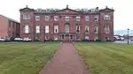
| |||
| Kilgraston Walled Garden | 56°20′19″N 3°25′20″W | Category C(S) | 4531 | Upload Photo | |||
| Balendrick House | 56°20′32″N 3°25′40″W | Category B | 4532 | Upload Photo | |||
| Bridge Of Earn, Back Street, Burnbrae, Burnside And Fetteresk | 56°20′58″N 3°24′19″W | Category C(S) | 4542 | Upload Photo | |||
| Moncreiffe Estate, West Lodge Including Gate And Quadrant Walls | 56°21′30″N 3°24′51″W | Category C(S) | 51443 | Upload Photo | |||
| Bridge Of Earn Former Earnbank Hotel | 56°20′58″N 3°24′11″W | Category C(S) | 4515 | Upload Photo | |||
| Dunbarney Old Churchyard, Near Dunbarney House | 56°21′18″N 3°26′11″W | Category B | 4516 | Upload Photo | |||
| Pitkeathly, Wellhouse Cottages | 56°20′31″N 3°26′00″W | Category B | 4523 | Upload Photo | |||
| Parish Church Of Dunbarney | 56°21′02″N 3°24′33″W | Category C(S) | 4537 | Upload Photo | |||
| Cyprus Inn Bridge Of Earn | 56°20′58″N 3°24′20″W | Category C(S) | 4541 | Upload Photo | |||
| Gilloch Hall Bridge Of Earn | 56°20′57″N 3°24′18″W | Category C(S) | 4509 | Upload Photo | |||
| House And Surgery (Dr Paul Mackenzie) Viewfield, Inverine Main Street | 56°20′55″N 3°24′22″W | Category C(S) | 4513 | Upload Photo | |||
| Kilgraston House Former Stable Block | 56°20′29″N 3°25′07″W | Category B | 4530 | Upload Photo | |||
| Pitkeathly Wells Farmhouse | 56°20′33″N 3°26′04″W | Category C(S) | 4524 | Upload Photo | |||
| Kilgraston House Gates | 56°20′28″N 3°24′37″W | Category B | 4528 | Upload Photo | |||
| Moncreiffe Estate, East Gate | 56°21′12″N 3°24′20″W | Category C(S) | 51437 | Upload Photo | |||
| Moncreiffe Estate, Garden Cottage, East And West | 56°21′31″N 3°23′25″W | Category C(S) | 51441 | Upload Photo | |||
| Moncreiffe Estate, Walled Garden And Ha-Ha | 56°21′32″N 3°23′39″W | Category C(S) | 51442 | Upload Photo | |||
| Masonic Hall (Former Free Church Hall And Beadle's House) Bridge Of Earn | 56°20′55″N 3°24′16″W | Category C(S) | 4510 | Upload Photo | |||
| Haughfield House Kintillo | 56°20′37″N 3°24′35″W | Category C(S) | 4514 | Upload Photo | |||
| Dunbarney House Windmill | 56°20′58″N 3°26′45″W | Category B | 4520 | 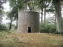
| |||
| Balendrick House Stables | 56°20′31″N 3°25′37″W | Category C(S) | 4533 | Upload Photo | |||
| Moncreiffe Estate, Moncreiffe House Including Walls, Ancillary Buildings And Gatepiers | 56°21′31″N 3°23′55″W | Category B | 4535 | 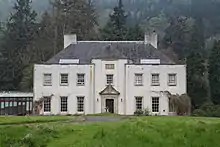
| |||
| Dunbarney Churchyard | 56°21′02″N 3°24′35″W | Category C(S) | 4539 | Upload Photo | |||
| Manse Of Dunbarney | 56°21′05″N 3°24′33″W | Category C(S) | 4540 | Upload Photo | |||
| Moncreiffe Estate, Gamekeeper's Cottage And Kennels | 56°21′33″N 3°24′39″W | Category C(S) | 51440 | Upload Photo | |||
| Dunbarney House, Including Offices, And Garden Walls | 56°21′09″N 3°26′25″W | Category B | 4517 | Upload Photo | |||
| Dunbarney House Sundial | 56°21′08″N 3°26′24″W | Category B | 4518 | Upload Photo | |||
| Dunbarney House Doocot | 56°21′05″N 3°26′30″W | Category B | 4519 | Upload Photo | |||
| Wallacetown Farmhouse | 56°21′19″N 3°22′12″W | Category B | 4505 | Upload Photo | |||
| Former Free Church (I Imrie, Antiques) Bridge Of Earn | 56°20′55″N 3°24′16″W | Category C(S) | 4511 | Upload Photo | |||
| 'sealsbridge House' Bridge Of Earn | 56°20′54″N 3°24′13″W | Category C(S) | 4512 | Upload Photo | |||
| Viewfield | 56°20′45″N 3°25′56″W | Category C(S) | 4522 | Upload Photo | |||
| Pitkeathly Wells Steading | 56°20′34″N 3°26′05″W | Category C(S) | 4525 | Upload Photo | |||
| Glenearn House Gatepiers | 56°20′06″N 3°26′00″W | Category B | 4526 | Upload Photo | |||
| Parish Church Of Dunbarney, Session Room | 56°21′01″N 3°24′33″W | Category C(S) | 4538 | Upload Photo | |||
| Moncreiffe Estate, Filter Bed And Water Tank | 56°21′37″N 3°23′56″W | Category C(S) | 51438 | Upload Photo |
Key
The scheme for classifying buildings in Scotland is:
- Category A: "buildings of national or international importance, either architectural or historic; or fine, little-altered examples of some particular period, style or building type."[1]
- Category B: "buildings of regional or more than local importance; or major examples of some particular period, style or building type, which may have been altered."[1]
- Category C: "buildings of local importance; lesser examples of any period, style, or building type, as originally constructed or moderately altered; and simple traditional buildings which group well with other listed buildings."[1]
In March 2016 there were 47,288 listed buildings in Scotland. Of these, 8% were Category A, and 50% were Category B, with the remaining 42% being Category C.[2]
Notes
- Sometimes known as OSGB36, the grid reference (where provided) is based on the British national grid reference system used by the Ordnance Survey.
• "Guide to National Grid". Ordnance Survey. Retrieved 12 December 2007.
• "Get-a-map". Ordnance Survey. Retrieved 17 December 2007. - Historic Environment Scotland assign a unique alphanumeric identifier to each designated site in Scotland, for listed buildings this always begins with "LB", for example "LB12345".
References
- All entries, addresses and coordinates are based on data from Historic Scotland. This data falls under the Open Government Licence
- "What is Listing?". Historic Environment Scotland. Retrieved 29 May 2018.
- Scotland's Historic Environment Audit 2016 (PDF). Historic Environment Scotland and the Built Environment Forum Scotland. pp. 15–16. Retrieved 29 May 2018.
This article is issued from Wikipedia. The text is licensed under Creative Commons - Attribution - Sharealike. Additional terms may apply for the media files.