List of listed buildings in Tibbermore
List
| Name | Location | Date Listed | Grid Ref. [note 1] | Geo-coordinates | Notes | LB Number [note 2] | Image |
|---|---|---|---|---|---|---|---|
| Manse Of Tibbermore | 56°23′34″N 3°32′13″W | Category B | 18299 |  Upload Photo | |||
| North Blackruthven | 56°24′09″N 3°31′00″W | Category B | 18302 | Upload Photo | |||
| Low's Work Cottages | 56°24′49″N 3°30′33″W | Category B | 18305 | Upload Photo | |||
| Dupplin Icehouse | 56°22′05″N 3°33′51″W | Category C(S) | 18300 | Upload Photo | |||
| Huntingtowerfield, S. Front Section Of Bleachwork | 56°24′53″N 3°30′18″W | Category B | 18306 | Upload Photo | |||
| Waterside Cottages, Huntingtowerfield | 56°24′59″N 3°29′55″W | Category B | 18307 | Upload Photo | |||
| West Mains Of Huntingtower Farmhouse | 56°24′14″N 3°30′05″W | Category B | 18313 | Upload Photo | |||
| Ruthven House Garden Wall And Lodge | 56°24′47″N 3°29′30″W | Category B | 18310 | Upload Photo | |||
| Newhouse Farmhouse | 56°24′08″N 3°29′20″W | Category B | 18312 | Upload Photo | |||
| Newhouse Steading | 56°24′08″N 3°29′20″W | Category C(S) | 19872 | Upload Photo | |||
| Huntingtower Castle | 56°24′34″N 3°29′18″W | 15th-century tower extended in 16th and 17th centuries | 18311 | 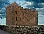
| |||
| Huntingtowerfield, Former Printhouse And Works Chapel With Linking Wall | 56°24′51″N 3°30′15″W | Category B | 19871 | Upload Photo | |||
| Tibbermore Parish Church Graveyard | 56°23′35″N 3°32′17″W | Category C(S) | 18298 | Upload Photo | |||
| Low's Work Weir | 56°24′51″N 3°30′33″W | Category B | 18304 | Upload Photo | |||
| Ruthven House | 56°24′48″N 3°29′28″W | Category B | 18309 | Upload Photo | |||
| North Blackruthven Lodge | 56°24′14″N 3°30′52″W | Category B | 18303 | Upload Photo | |||
| Tibbermore Parish Church | 56°23′36″N 3°32′14″W | Category B | 18297 | Upload Photo | |||
| Tofthouses | 56°24′32″N 3°30′40″W | Category B | 18301 | Upload Photo | |||
| Grey Row, Ruthven | 56°24′42″N 3°29′43″W | Category C(S) | 18308 | Upload Photo |
Key
The scheme for classifying buildings in Scotland is:
- Category A: "buildings of national or international importance, either architectural or historic; or fine, little-altered examples of some particular period, style or building type."[1]
- Category B: "buildings of regional or more than local importance; or major examples of some particular period, style or building type, which may have been altered."[1]
- Category C: "buildings of local importance; lesser examples of any period, style, or building type, as originally constructed or moderately altered; and simple traditional buildings which group well with other listed buildings."[1]
In March 2016 there were 47,288 listed buildings in Scotland. Of these, 8% were Category A, and 50% were Category B, with the remaining 42% being Category C.[2]
Notes
- Sometimes known as OSGB36, the grid reference (where provided) is based on the British national grid reference system used by the Ordnance Survey.
• "Guide to National Grid". Ordnance Survey. Retrieved 12 December 2007.
• "Get-a-map". Ordnance Survey. Retrieved 17 December 2007. - Historic Environment Scotland assign a unique alphanumeric identifier to each designated site in Scotland, for listed buildings this always begins with "LB", for example "LB12345".
References
- All entries, addresses and coordinates are based on data from Historic Scotland. This data falls under the Open Government Licence
- "What is Listing?". Historic Environment Scotland. Retrieved 29 May 2018.
- Scotland's Historic Environment Audit 2016 (PDF). Historic Environment Scotland and the Built Environment Forum Scotland. pp. 15–16. Retrieved 29 May 2018.
This article is issued from Wikipedia. The text is licensed under Creative Commons - Attribution - Sharealike. Additional terms may apply for the media files.