List of listed buildings in Dull, Perth and Kinross
List
| Name | Location | Date Listed | Grid Ref. [note 1] | Geo-coordinates | Notes | LB Number [note 2] | Image |
|---|---|---|---|---|---|---|---|
| Camserney Longhouse And Peat Shed | 56°37′12″N 3°55′47″W | Category A | 5732 |  Upload Photo | |||
| Turrerich Bridge Over River Quaich | 56°31′32″N 3°51′52″W | Category C(S) | 5739 | Upload Photo | |||
| St Adamnan's Parish Church Graveyard | 56°37′08″N 3°56′48″W | Category B | 5748 | Upload Photo | |||
| Glengoulandie | 56°38′55″N 4°00′41″W | Category C(S) | 5740 | Upload Photo | |||
| Tummel Bridge | 56°42′28″N 4°01′23″W | Category A | 5742 | 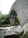
| |||
| Foss And Tummel Parish Church, Foss | 56°41′55″N 3°58′40″W | Category C(S) | 5743 | Upload Photo | |||
| St Adamnan's Parish Church Dull | 56°37′09″N 3°56′49″W | Category B | 5747 | 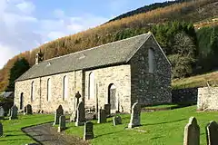
| |||
| Newhall Bridge Over River Tay | 56°35′55″N 3°58′25″W | Category B | 5757 | Upload Photo | |||
| Comrie Castle | 56°36′49″N 3°58′43″W | Category B | 5759 | Upload Photo | |||
| Camserney, Redgorton | 56°37′19″N 3°55′43″W | Category C(S) | 51169 | Upload Photo | |||
| Dunskiag Farmhouse And Steading | 56°36′40″N 3°53′29″W | Category B | 6635 | Upload Photo | |||
| Garrow Bridge Over River Quaich | 56°32′22″N 3°54′41″W | Category C(S) | 6194 | Upload Photo | |||
| Bolfracks | 56°36′37″N 3°55′15″W | Category B | 5737 | Upload Photo | |||
| Tullicro, East Cottage | 56°37′10″N 3°56′01″W | Category C(S) | 5751 | Upload Photo | |||
| Manse Of Dull | 56°37′02″N 3°57′10″W | Category B | 5750 | Upload Photo | |||
| Newhall | 56°35′50″N 3°58′18″W | Category B | 5753 | Upload Photo | |||
| Amulree And Strathbraan Parish Church With Graveyard, Gates And Gatepiers | 56°30′30″N 3°47′26″W | Category B | 6362 | 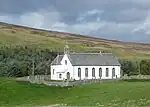
| |||
| Foss And Tummel Parish Church, Graveyard | 56°41′55″N 3°58′40″W | Category C(S) | 5744 | Upload Photo | |||
| Cross, Dull | 56°37′08″N 3°56′44″W | Category B | 5749 | Upload Photo | |||
| Main Lodge And Gates, Taymouth Castle | 56°35′50″N 3°58′01″W | Category B | 5752 | Upload Photo | |||
| Camserney, Old Mill Of Camserney And Mill House | 56°37′14″N 3°55′30″W | Category B | 5734 | Upload Photo | |||
| Camserney, Smithy Cottage, Former Smithy And Limekiln | 56°37′18″N 3°55′29″W | Category B | 5738 | Upload Photo | |||
| Tullicro, West Cottage Including The Barn And The Bothy | 56°37′10″N 3°56′04″W | Category B | 5756 | Upload Photo | |||
| Comrie Cottage (Formerly: Until Recently Property Of Comrie Farm, Now In Process Of Sale) | 56°36′50″N 3°59′14″W | Category B | 5760 | Upload Photo | |||
| Comrie Farm Steading, Millhouse, Tower House, Ghillies House And The Courtyard | 56°36′50″N 3°59′34″W | Category B | 5761 | Upload Photo | |||
| Grampian Hydro Electric Scheme, Tummel Power Station | 56°42′23″N 4°01′16″W | Category A | 51715 | Upload Photo | |||
| Keltneyburn Hall | 56°37′07″N 4°00′01″W | Category C(S) | 6361 | Upload Photo | |||
| Tomphubil Limekiln | 56°40′00″N 3°59′44″W | Category B | 5741 | Upload Photo | |||
| Camserney, Crachan Cottage Including Ancillary Buildings | 56°37′21″N 3°55′49″W | Category B | 5758 | Upload Photo |
Key
The scheme for classifying buildings in Scotland is:
- Category A: "buildings of national or international importance, either architectural or historic; or fine, little-altered examples of some particular period, style or building type."[1]
- Category B: "buildings of regional or more than local importance; or major examples of some particular period, style or building type, which may have been altered."[1]
- Category C: "buildings of local importance; lesser examples of any period, style, or building type, as originally constructed or moderately altered; and simple traditional buildings which group well with other listed buildings."[1]
In March 2016 there were 47,288 listed buildings in Scotland. Of these, 8% were Category A, and 50% were Category B, with the remaining 42% being Category C.[2]
Notes
- Sometimes known as OSGB36, the grid reference (where provided) is based on the British national grid reference system used by the Ordnance Survey.
• "Guide to National Grid". Ordnance Survey. Retrieved 12 December 2007.
• "Get-a-map". Ordnance Survey. Retrieved 17 December 2007. - Historic Environment Scotland assign a unique alphanumeric identifier to each designated site in Scotland, for listed buildings this always begins with "LB", for example "LB12345".
References
- All entries, addresses and coordinates are based on data from Historic Scotland. This data falls under the Open Government Licence
- "What is Listing?". Historic Environment Scotland. Retrieved 29 May 2018.
- Scotland's Historic Environment Audit 2016 (PDF). Historic Environment Scotland and the Built Environment Forum Scotland. pp. 15–16. Retrieved 29 May 2018.
This article is issued from Wikipedia. The text is licensed under Creative Commons - Attribution - Sharealike. Additional terms may apply for the media files.