List of listed buildings in Pitlochry, Perth and Kinross
List
| Name | Location | Date Listed | Grid Ref. [note 1] | Geo-coordinates | Notes | LB Number [note 2] | Image |
|---|---|---|---|---|---|---|---|
| 146-152 (Even Nos) Atholl Road | 56°42′15″N 3°44′15″W | Category C(S) | 39865 |  Upload Photo | |||
| 156 Atholl Road, Sunnybrae Cottage | 56°42′16″N 3°44′19″W | Category A | 39866 | .jpg.webp)
| |||
| Atholl Road, Baptist Church With Boundary Walls And Gates | 56°42′07″N 3°43′46″W | Category C(S) | 47508 | Upload Photo | |||
| 128 - 134 (Even Nos) Atholl Road And Birnam Place, The Arcade | 56°42′14″N 3°44′09″W | Category B | 47514 | Upload Photo | |||
| Knockfarrie Road, Knockfarrie Lodge, Including Ancillary Building | 56°42′01″N 3°43′24″W | Category C(S) | 47522 | Upload Photo | |||
| Strathview Terrace, Comar House, Including Terrace And Boundary Walls | 56°42′20″N 3°44′12″W | Category C(S) | 47543 | Upload Photo | |||
| Strathview Terrace, Pine Trees Hotel, Ancillary Building And Walled Garden | 56°42′24″N 3°44′33″W | Category C(S) | 47545 | Upload Photo | |||
| 36, 40 And 46 Atholl Road | 56°42′09″N 3°43′57″W | Category C(S) | 39852 | 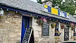
| |||
| Station Road, Pitlochry Station, Including Down Platform Building, Footbridge, Fountain And Signal Box | 56°42′09″N 3°44′08″W | Category A | 39867 | 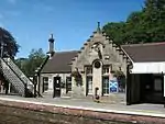
| |||
| 84 -104 (Even Nos) Atholl Road And Units 1, 2 And 2A Mill Lane, Alba Place | 56°42′13″N 3°44′05″W | Category B | 47512 | Upload Photo | |||
| Atholl Palace Hotel, Including Terraced Gardens | 56°42′06″N 3°43′11″W | Category B | 39856 | 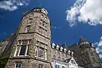
| |||
| 1 - 4 (Inclusive Nos) Port-Na-Craig Road, Including Boundary Walls | 56°41′53″N 3°44′02″W | Category C(S) | 39857 | 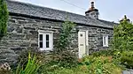
| |||
| Foss Road, Port-Na-Craig House, Including Walled Garden, Gatepiers And Gates | 56°41′54″N 3°44′30″W | Category B | 39859 | .jpg.webp)
| |||
| Moulin, Kirkmichael Road, Moulin Hotel | 56°42′47″N 3°43′37″W | Category C(S) | 39862 | Upload Photo | |||
| Atholl Road, War Memorial And Memorial Garden | 56°42′08″N 3°43′57″W | Category C(S) | 47510 | 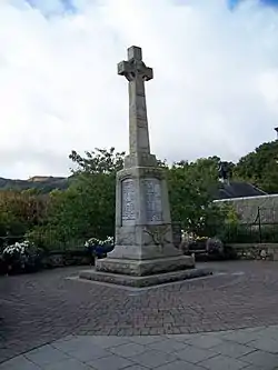
| |||
| Bonnethill Road And Toberargan Road, The Bank House, Including Ancillary Building, Gatepiers, Boundary Walls And Railings | 56°42′14″N 3°43′54″W | Category C(S) | 47516 | Upload Photo | |||
| Lower Oakfield, Ellangowan And Myrtlebank Cottage, Including Ancillary Building And Boundary Walls | 56°42′07″N 3°43′34″W | Category C(S) | 47523 | Upload Photo | |||
| Moulin, Kirkmichael Road, Blairmount With Gatepiers, Boundary Walls And Railings | 56°42′44″N 3°43′35″W | Category C(S) | 47529 | Upload Photo | |||
| Perth Road, Dundarach Hotel With Ancillary Building And Gatepiers | 56°42′00″N 3°43′38″W | Category B | 47533 | Upload Photo | |||
| 1-8 (Inclusive Nos) Rie-Achan Road, Scottish Veterans Garden City, Including Gatepiers | 56°42′11″N 3°44′33″W | Category C(S) | 47539 | Upload Photo | |||
| Toberargan Road, Toberargan House | 56°42′13″N 3°43′52″W | Category C(S) | 47548 | Upload Photo | |||
| Port-Na-Craig, Suspension Bridge | 56°41′55″N 3°43′57″W | Category B | 39858 | 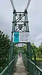
| |||
| Atholl Palace Hotel, Corrie House | 56°42′04″N 3°43′13″W | Category C(S) | 47506 | Upload Photo | |||
| Atholl Road, Fisher's Hotel, Including Glasshouses, Boundary Walls, Gatepiers, Gates And Railings | 56°42′11″N 3°44′05″W | Category C(S) | 47509 | 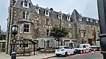
| |||
| 26 Atholl Road, Public Library And Council Offices, Former Union Bank, With Boundary Walls | 56°42′08″N 3°43′51″W | Category B | 47511 | Upload Photo | |||
| Knockard Road, Dun-Donnachaidh With Ancillary Building, Boundary Walls And Gatepiers | 56°42′21″N 3°43′46″W | Category C(S) | 47520 | Upload Photo | |||
| Knockfarrie Road, Easter Knockfarrie, Wester Knockfarrie And Knockfarrie Cottage, Including Ancillary Building And Terrace Walls | 56°42′02″N 3°43′20″W | Category C(S) | 47521 | Upload Photo | |||
| Moulin, Baledmund Road, Bridge Over Moulin Burn | 56°42′48″N 3°43′38″W | Category C(S) | 47526 | Upload Photo | |||
| Perth Road, Blair Athol Distillery, Manager's House, Former Manse | 56°41′58″N 3°43′21″W | Category C(S) | 47531 | Upload Photo | |||
| Perth Road, Blair Athol Distillery Including Boundary Walls | 56°41′55″N 3°43′23″W | Category B | 47532 | Upload Photo | |||
| Church Road, Pitlochry Parish Church, Including Celtic Cross Memorial | 56°42′15″N 3°43′58″W | Category A | 39850 | 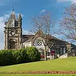
| |||
| Moulin, Moulin Church (Church Of Scotland) With Graveyard, Gates, Gatepiers And Graveyard Walls | 56°42′45″N 3°43′34″W | Category B | 39860 | Upload Photo | |||
| 124 And 126 Atholl Road | 56°42′14″N 3°44′09″W | Category C(S) | 47513 | Upload Photo | |||
| Lower Oakfield And Toberargan Road, Inveresk | 56°42′07″N 3°43′46″W | Category C(S) | 47525 | Upload Photo | |||
| Tummel Garry Hydro Electric Scheme, Pitlochry Power Station And Dam, Including Boundary Walls | 56°41′56″N 3°44′24″W | Category A | 47534 | .jpg.webp)
| |||
| Port-Na-Craig Road, Fonab House, Including Ancillary Buildings, Walled Garden, Gatepiers And Boundary Walls | 56°41′51″N 3°43′49″W | Category B | 47537 | Upload Photo | |||
| Strathview Terrace, Pine Trees Hotel, Coach House | 56°42′26″N 3°44′34″W | Category B | 47546 | Upload Photo | |||
| Atholl Road And Cloichard Place, The Old Smithy | 56°42′16″N 3°44′17″W | Category B | 39853 | 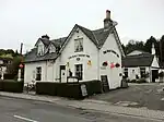
| |||
| Perth Road, Holy Trinity Episcopal Church Including, Church Hall, Lychgate, Graveyard And Boundary Walls | 56°42′00″N 3°43′25″W | Category B | 39854 | Upload Photo | |||
| 2 East Moulin Road, Birchwood Hotel, Including Boundary Walls | 56°42′05″N 3°43′28″W | Category B | 47517 | Upload Photo | |||
| Golf Course Road, Torrdarach Hotel, Including Ancillary Building, Boundary Walls And Gatepiers | 56°42′23″N 3°44′17″W | Category C(S) | 47518 | Upload Photo | |||
| Moulin Hall | 56°42′44″N 3°43′32″W | Category C(S) | 47528 | Upload Photo | |||
| Moulin, Moulin Square, Bruach Fuarain | 56°42′46″N 3°43′33″W | Category C(S) | 47530 | Upload Photo | |||
| Strathview Terrace, Pine Trees Hotel, Lodge House, Gatepiers, Gates And Boundary Walls | 56°42′22″N 3°44′25″W | Category C(S) | 47547 | Upload Photo | |||
| West Moulin Road, Town Hall, Including Boundary Walls | 56°42′17″N 3°44′01″W | Category B | 47549 | .jpg.webp)
| |||
| Atholl Palace Hotel, The Lodge, Including Gatepiers, Gates And Boundary Walls | 56°42′02″N 3°43′26″W | Category B | 47507 | Upload Photo | |||
| Auchnahyle Steading And Horse Mill | 56°42′21″N 3°43′01″W | Category B | 47515 | Upload Photo | |||
| Higher Oakfield, Knockendarroch House Hotel | 56°42′13″N 3°43′38″W | Category C(S) | 47519 | Upload Photo | |||
| Lower Oakfield, Yeomans, Including Ancillary Buildings, Boundary Walls And Gate | 56°42′07″N 3°43′33″W | Category C(S) | 47524 | Upload Photo | |||
| Moulin, Baledmund Road, Old Mill | 56°42′51″N 3°43′37″W | Category B | 47527 | Upload Photo | |||
| Port-Na-Craig Road, Ferryman's Cottage, Including Boundary Walls | 56°41′54″N 3°44′00″W | Category B | 47535 | 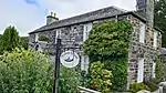
| |||
| Port-Na-Craig Road, Fonab Coach House | 56°41′52″N 3°43′53″W | Category B | 47536 | Upload Photo | |||
| West Moulin Road, Wellwood, Including Boundary Walls And Gatepiers | 56°42′20″N 3°44′05″W | Category C(S) | 47550 | Upload Photo | |||
| Strathview Terrace, Pine Trees Hotel Formerly Tom-Na-Monachan | 56°42′24″N 3°44′33″W | Category C(S) | 50603 | Upload Photo | |||
| 51 Atholl Road Including Ancillary Building | 56°42′09″N 3°43′58″W | Category C(S) | 39851 | 
| |||
| Moulin, Manse Road, Old Moulin (Formerly Manseholm), Including Boundary Walls And Gates | 56°42′47″N 3°43′25″W | Category C(S) | 39863 | Upload Photo | |||
| Port-Na-Craig Road, Portnacraig Inn, Including Boundary Walls | 56°41′55″N 3°44′03″W | Category B | 47538 | 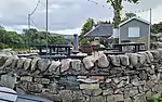
| |||
| Strathview Terrace, Craigard, Including Terrace And Boundary Walls | 56°42′19″N 3°44′09″W | Category C(S) | 47544 | Upload Photo |
Key
The scheme for classifying buildings in Scotland is:
- Category A: "buildings of national or international importance, either architectural or historic; or fine, little-altered examples of some particular period, style or building type."[1]
- Category B: "buildings of regional or more than local importance; or major examples of some particular period, style or building type, which may have been altered."[1]
- Category C: "buildings of local importance; lesser examples of any period, style, or building type, as originally constructed or moderately altered; and simple traditional buildings which group well with other listed buildings."[1]
In March 2016 there were 47,288 listed buildings in Scotland. Of these, 8% were Category A, and 50% were Category B, with the remaining 42% being Category C.[2]
Notes
- Sometimes known as OSGB36, the grid reference (where provided) is based on the British national grid reference system used by the Ordnance Survey.
• "Guide to National Grid". Ordnance Survey. Retrieved 12 December 2007.
• "Get-a-map". Ordnance Survey. Retrieved 17 December 2007. - Historic Environment Scotland assign a unique alphanumeric identifier to each designated site in Scotland, for listed buildings this always begins with "LB", for example "LB12345".
References
- All entries, addresses and coordinates are based on data from Historic Scotland. This data falls under the Open Government Licence
- "What is Listing?". Historic Environment Scotland. Retrieved 29 May 2018.
- Scotland's Historic Environment Audit 2016 (PDF). Historic Environment Scotland and the Built Environment Forum Scotland. pp. 15–16. Retrieved 29 May 2018.
This article is issued from Wikipedia. The text is licensed under Creative Commons - Attribution - Sharealike. Additional terms may apply for the media files.