List of listed buildings in Fowlis Wester, Perth and Kinross
List
| Name | Location | Date Listed | Grid Ref. [note 1] | Geo-coordinates | Notes | LB Number [note 2] | Image |
|---|---|---|---|---|---|---|---|
| Conyachan Farm (Conichan On Map) | 56°28′06″N 3°53′00″W | Category C(S) | 12215 |  Upload Photo | |||
| Tomenbowie, Burial Ground Near Conyachan Farm | 56°28′12″N 3°53′25″W | Category C(S) | 12216 | Upload Photo | |||
| Abercairny House Gardens, 2 Marble Busts At W. Gate On Main E.-W. Avenue | 56°22′56″N 3°45′49″W | Category B | 12204 | Upload Photo | |||
| Glenalmond House | 56°26′26″N 3°44′04″W | Category B | 12217 | Upload Photo | |||
| Balgowan School, Dalbarber | 56°24′22″N 3°37′47″W | Category C(S) | 12222 | Upload Photo | |||
| Churchyard Walls, Gate And Gravestones | 56°23′49″N 3°44′17″W | Category B | 12247 | Upload Photo | |||
| Village Cottages, Fowlis, J. Mccoll And One Vacant | 56°23′47″N 3°44′22″W | Category C(S) | 12252 | Upload Photo | |||
| The Grange Fowlis Wester | 56°23′36″N 3°44′28″W | Category B | 12253 | Upload Photo | |||
| Connachan Lodge | 56°25′39″N 3°47′31″W | Category A | 12213 | Upload Photo | |||
| Tulchan Gardens | 56°26′07″N 3°42′19″W | Category B | 12219 | Upload Photo | |||
| Parish Church (St. Beanus) | 56°23′48″N 3°44′18″W | Category B | 12246 | 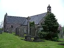
| |||
| Cultoquhey House Sundial | 56°23′20″N 3°47′45″W | Category B | 12209 | Upload Photo | |||
| Auchilhanzie | 56°23′48″N 3°47′06″W | Category B | 12212 | Upload Photo | |||
| Newton Bridge On A822 Over River Almond | 56°27′45″N 3°48′25″W | Category B | 12214 | Upload Photo | |||
| Carsehead Farmhouse | 56°23′16″N 3°41′52″W | Category B | 12223 | Upload Photo | |||
| Fowlis Wester, K6 Telephone Kiosk At Post Office | 56°23′47″N 3°44′18″W | Category B | 12225 | Upload Photo | |||
| Village Hall, Fowlis Old Section Only | 56°23′47″N 3°44′20″W | Category C(S) | 12251 | Upload Photo | |||
| Abercairny, Crieff Lodge | 56°23′17″N 3°46′29″W | Category B | 12254 | Upload Photo | |||
| Abercairny, Garden Lodge | 56°23′02″N 3°46′46″W | Category B | 12255 | Upload Photo | |||
| Abercairny Sundial | 56°22′52″N 3°45′54″W | Category A | 12257 | Upload Photo | |||
| Glen Cottage, Croftmore And Robertson, Glen Road, Gilmerton | 56°23′30″N 3°48′25″W | Category C(S) | 12211 | Upload Photo | |||
| West Tulchan | 56°26′05″N 3°42′07″W | Category C(S) | 12220 | Upload Photo | |||
| Keillour Castle | 56°24′42″N 3°39′40″W | Category C(S) | 12221 | Upload Photo | |||
| Schoolhouse, Fowlis Village | 56°23′46″N 3°44′19″W | Category C(S) | 12249 | Upload Photo | |||
| Post Office And Shop Fowlis Village | 56°23′47″N 3°44′18″W | Category C(S) | 12250 | Upload Photo | |||
| Abercairny House Gardens, Statue Avenue | 56°22′56″N 3°45′49″W | Category B | 12258 | Upload Photo | |||
| Bridge Of Buchanty | 56°26′07″N 3°43′51″W | Category B | 12218 | Upload Photo | |||
| Bridge On A822 Over Newton Burn | 56°27′56″N 3°48′16″W | Category C(S) | 13809 | Upload Photo | |||
| Abercairny Stable Block | 56°22′58″N 3°45′37″W | Category B | 12206 | 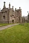
| |||
| Cultoquhey House (Hotel) | 56°23′21″N 3°47′43″W | Category B | 12208 | Upload Photo | |||
| Abercairny, Avenue Of Busts | 56°22′56″N 3°45′49″W | Category B | 12205 | 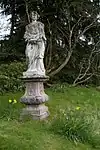
| |||
| Store, Glen Road, Gilmerton, The Property Of Hugh Mccall Smith. (Former Free Church) | 56°23′31″N 3°48′24″W | Category B | 12210 | Upload Photo | |||
| Fowlis Wester Parish Church, Cross Of Fowlis | 56°23′48″N 3°44′17″W | Category B | 12248 | Upload Photo | |||
| Abercairny Doocot | 56°23′01″N 3°46′34″W | Category B | 12256 | Upload Photo |
Key
The scheme for classifying buildings in Scotland is:
- Category A: "buildings of national or international importance, either architectural or historic; or fine, little-altered examples of some particular period, style or building type."[1]
- Category B: "buildings of regional or more than local importance; or major examples of some particular period, style or building type, which may have been altered."[1]
- Category C: "buildings of local importance; lesser examples of any period, style, or building type, as originally constructed or moderately altered; and simple traditional buildings which group well with other listed buildings."[1]
In March 2016 there were 47,288 listed buildings in Scotland. Of these, 8% were Category A, and 50% were Category B, with the remaining 42% being Category C.[2]
Notes
- Sometimes known as OSGB36, the grid reference (where provided) is based on the British national grid reference system used by the Ordnance Survey.
• "Guide to National Grid". Ordnance Survey. Retrieved 12 December 2007.
• "Get-a-map". Ordnance Survey. Retrieved 17 December 2007. - Historic Environment Scotland assign a unique alphanumeric identifier to each designated site in Scotland, for listed buildings this always begins with "LB", for example "LB12345".
References
- All entries, addresses and coordinates are based on data from Historic Scotland. This data falls under the Open Government Licence
- "What is Listing?". Historic Environment Scotland. Retrieved 29 May 2018.
- Scotland's Historic Environment Audit 2016 (PDF). Historic Environment Scotland and the Built Environment Forum Scotland. pp. 15–16. Retrieved 29 May 2018.
This article is issued from Wikipedia. The text is licensed under Creative Commons - Attribution - Sharealike. Additional terms may apply for the media files.