List of listed buildings in Kinross, Perth and Kinross
List
| Name | Location | Date Listed | Grid Ref. [note 1] | Geo-coordinates | Notes | LB Number [note 2] | Image |
|---|---|---|---|---|---|---|---|
| Kirkland's Hotel 20 High Street | 56°12′21″N 3°25′20″W | Category B | 36284 |  Upload Photo | |||
| Clydesdale Bank 37 High Street | 56°12′22″N 3°25′17″W | Category B | 36289 | Upload Photo | |||
| Salutation Inn, 99 High Street | 56°12′15″N 3°25′15″W | Category B | 36290 | Upload Photo | |||
| 3 And 5 School Wynd | 56°12′13″N 3°25′18″W | Category B | 36292 | Upload Photo | |||
| 108 High Street (Old Post Office) | 56°12′11″N 3°25′16″W | Category B | 36298 | Upload Photo | |||
| Kinross House | 56°12′11″N 3°24′35″W | Category A | 11200 | _elevation_of_Kinross_House%252C_from_S.jpg.webp)
| |||
| Victoria Bar 121-123 High Street | 56°12′11″N 3°25′14″W | Category C(S) | 36301 | Upload Photo | |||
| Old Red Lion Inn (Annexe To Victoria Bar) | 56°12′11″N 3°25′14″W | Category C(S) | 36302 | Upload Photo | |||
| 11, 13 School Wynd | 56°12′13″N 3°25′19″W | Category C(S) | 36307 | Upload Photo | |||
| Lethangie Estate, Stable Block | 56°13′11″N 3°24′48″W | Category B | 12965 | Upload Photo | |||
| Kinross Stables | 56°12′16″N 3°24′48″W | Category B | 11201 | Upload Photo | |||
| 49 Muirs, The Muirs Inn Including Gatepiers And Boundary Walls | 56°12′40″N 3°25′30″W | Category C(S) | 47316 | 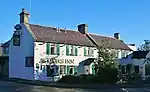
| |||
| Turfhills House | 56°12′34″N 3°26′35″W | Category B | 43207 | Upload Photo | |||
| Kinross West, Church Of Scotland, (Kinross Parish Kirk) Station Road | 56°12′20″N 3°25′25″W | Category B | 36283 | Upload Photo | |||
| 'Mossgrove', 18 Muirs | 56°12′35″N 3°25′31″W | Category B | 36287 | Upload Photo | |||
| Gates And Lodges At Entrance To Kinross House Policies. Avenue Road | 56°12′15″N 3°25′11″W | Category B | 36291 | Upload Photo | |||
| Loch Leven Inn 6 Swan's Acre | 56°12′15″N 3°25′17″W | Category C(S) | 36294 | Upload Photo | |||
| Burnbrae Farmhouse, Dairy And Walled Garden | 56°12′46″N 3°28′58″W | Category B | 13325 | Upload Photo | |||
| County Buildings 21-25 High Street | 56°12′24″N 3°25′18″W | Category B | 36288 | .jpg.webp)
| |||
| 8 School Wynd And 5 Swan's Acre (Tighnuilt) | 56°12′14″N 3°25′19″W | Category C(S) | 36293 | Upload Photo | |||
| 98, 100, 102 High Street | 56°12′12″N 3°25′16″W | Category B | 36295 | Upload Photo | |||
| 7, 9, School Wynd | 56°12′13″N 3°25′18″W | Category C(S) | 36306 | Upload Photo | |||
| 10 Brewery Lane | 56°12′13″N 3°25′20″W | Category C(S) | 36308 | Upload Photo | |||
| Lethangie House With Garden Walls And Gazebo To West, And Summerhouse To East | 56°13′10″N 3°24′57″W | Category B | 12961 | Upload Photo | |||
| Watch Tower, East Burial Ground | 56°12′03″N 3°24′24″W | Category C(S) | 11198 | Upload Photo | |||
| Municipal Chambers 18 High Street | 56°12′22″N 3°25′20″W | Category B | 36285 | Upload Photo | |||
| The Bank House, Former British Linen Bank, 2 High Street | 56°12′28″N 3°25′26″W | Category B | 36286 | Upload Photo | |||
| Old Manse, 8 Sandport | 56°12′04″N 3°25′15″W | Category B | 36304 | Upload Photo | |||
| Mercat Cross Sandport | 56°12′05″N 3°25′17″W | Category B | 36305 | Upload Photo | |||
| Lethangie Estate, South Lodge Including Gatepiers | 56°13′07″N 3°24′54″W | Category B | 12962 | Upload Photo | |||
| Annacroich Farm-House | 56°10′20″N 3°25′32″W | Category B | 11203 | Upload Photo | |||
| Fountain, High Street | 56°12′12″N 3°25′16″W | Category C(S) | 36296 | 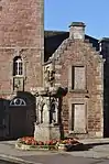
| |||
| The Clock Tower, High Street | 56°12′12″N 3°25′16″W | Category B | 36297 | 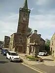
| |||
| 110 High Street, Former Town Hall | 56°12′11″N 3°25′17″W | Category B | 36299 | 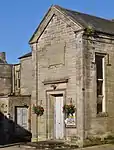
| |||
| Lethangie Estate, Farmbuildings To E Of House | 56°13′09″N 3°24′49″W | Category B | 12964 | Upload Photo | |||
| Balado Bridge | 56°12′28″N 3°27′29″W | Category B | 11202 | Upload Photo | |||
| The Muirs, St Paul's Episcopal Church Including Boundary Walls And Piers | 56°12′41″N 3°25′30″W | Category B | 48623 | Upload Photo | |||
| 112 High Street, Carnegie Public Library | 56°12′10″N 3°25′17″W | Category C(S) | 48649 | Upload Photo | |||
| Old County Building 109-113 High Street | 56°12′12″N 3°25′15″W | Category B | 36300 | 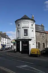
| |||
| Lethangie Estate, Walled Kitchen Garden, Dovecote And Outbuildings | 56°13′09″N 3°24′45″W | Category B | 12966 | Upload Photo | |||
| Loch Leven Castle Castle Island Lochleven | 56°12′03″N 3°23′30″W | Category A | 11199 | 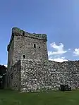
| |||
| Church Hall (Old East U.P. Church) | 56°12′12″N 3°25′12″W | Category C(S) | 36303 | Upload Photo | |||
| 12 Brewery Lane | 56°12′13″N 3°25′20″W | Category C(S) | 36309 | Upload Photo | |||
| Lethangie Estate, West Lodge Including Gatepiers | 56°13′12″N 3°25′30″W | Category B | 12963 | Upload Photo | |||
| Bruce Mortuary Chapel, East Burial Ground | 56°12′03″N 3°24′23″W | Category C(S) | 11197 | Upload Photo |
Key
The scheme for classifying buildings in Scotland is:
- Category A: "buildings of national or international importance, either architectural or historic; or fine, little-altered examples of some particular period, style or building type."[1]
- Category B: "buildings of regional or more than local importance; or major examples of some particular period, style or building type, which may have been altered."[1]
- Category C: "buildings of local importance; lesser examples of any period, style, or building type, as originally constructed or moderately altered; and simple traditional buildings which group well with other listed buildings."[1]
In March 2016 there were 47,288 listed buildings in Scotland. Of these, 8% were Category A, and 50% were Category B, with the remaining 42% being Category C.[2]
Notes
- Sometimes known as OSGB36, the grid reference (where provided) is based on the British national grid reference system used by the Ordnance Survey.
• "Guide to National Grid". Ordnance Survey. Retrieved 12 December 2007.
• "Get-a-map". Ordnance Survey. Retrieved 17 December 2007. - Historic Environment Scotland assign a unique alphanumeric identifier to each designated site in Scotland, for listed buildings this always begins with "LB", for example "LB12345".
References
- All entries, addresses and coordinates are based on data from Historic Scotland. This data falls under the Open Government Licence
- "What is Listing?". Historic Environment Scotland. Retrieved 29 May 2018.
- Scotland's Historic Environment Audit 2016 (PDF). Historic Environment Scotland and the Built Environment Forum Scotland. pp. 15–16. Retrieved 29 May 2018.
This article is issued from Wikipedia. The text is licensed under Creative Commons - Attribution - Sharealike. Additional terms may apply for the media files.