List of listed buildings in Little Dunkeld, Perth and Kinross
List
| Name | Location | Date Listed | Grid Ref. [note 1] | Geo-coordinates | Notes | LB Number [note 2] | Image |
|---|---|---|---|---|---|---|---|
| Elsey Cottage, Birnam | 56°33′21″N 3°34′45″W | Category C(S) | 13733 |  Upload Photo | |||
| Neil Gow's Cottage, Inver | 56°33′42″N 3°36′10″W | Category B | 11163 | Upload Photo | |||
| Merryburn Hotel, Station Road, Birnam | 56°33′27″N 3°34′38″W | Category C(S) | 11082 | .jpg.webp)
| |||
| Birnam Terrace, Birnam | 56°33′28″N 3°34′37″W | Category C(S) | 11083 | Upload Photo | |||
| Thomas Ormsby And Mary Newham Underwood, Fountain, Birnam | 56°33′32″N 3°34′38″W | Category C(S) | 11088 | Upload Photo | |||
| Oransay, Oak Road, Birnam | 56°33′38″N 3°34′37″W | Category C(S) | 11090 | Upload Photo | |||
| The Rectory, Oak Road, Birnam | 56°33′31″N 3°34′32″W | Category C(S) | 11091 | Upload Photo | |||
| Inver, K6 Telephone Kiosk At Inver Square | 56°33′41″N 3°36′06″W | Category B | 11103 | Upload Photo | |||
| Hermitage Bridge Over R. Braan | 56°33′26″N 3°36′51″W | Category A | 11104 | 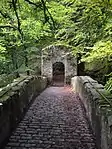
| |||
| Newton Bridge Over R. Braan | 56°32′45″N 3°39′43″W | Category B | 11108 | Upload Photo | |||
| Dalguise Church | 56°36′12″N 3°38′29″W | Category B | 11113 | Upload Photo | |||
| Dalguise House, Column | 56°36′39″N 3°38′43″W | Category B | 11115 | Upload Photo | |||
| Kinnaird House | 56°37′49″N 3°39′36″W | Category B | 11118 | Upload Photo | |||
| Murthly Terrace (All Except Mcmurray At No 1) And Glen Afric, Perth Road, Birnam | 56°33′32″N 3°34′37″W | Category B | 11125 | Upload Photo | |||
| Stair Bridge, Rohallion Over Birnam Burn | 56°32′11″N 3°33′58″W | Category C(S) | 11142 | Upload Photo | |||
| Walled Garden, Garden House, Gatepiers On E., Steps, Urns, Etc. On East Of Castle | 56°32′28″N 3°30′38″W | Category A | 11147 | Upload Photo | |||
| Colryden Lodge, Murthly | 56°31′58″N 3°31′22″W | Category B | 11148 | 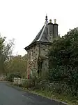
| |||
| Dalguise House | 56°36′40″N 3°38′43″W | Category B | 13734 | Upload Photo | |||
| Bridge Over Birnam Burn To S. Of Roman Bridge | 56°32′17″N 3°32′05″W | Category C(S) | 13737 | Upload Photo | |||
| East Gates, Near Gellyburn | 56°32′15″N 3°28′35″W | Category C(S) | 11150 | .jpg.webp)
| |||
| Ossian's Cave | 56°33′21″N 3°37′12″W | Category B | 11105 | 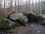
| |||
| Amulree Bridge | 56°30′37″N 3°47′18″W | Category B | 11123 | 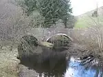
| |||
| The School House, Perth Road, Birnam | 56°33′28″N 3°34′32″W | Category C(S) | 11130 | Upload Photo | |||
| Dunkeld and Birnam railway station | 56°33′25″N 3°34′42″W | Category A | 11139 | 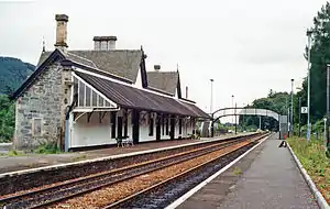
| |||
| Bee Cottage, Pass Of Birnam | 56°32′06″N 3°32′31″W | Category B | 11144 | Upload Photo | |||
| Murthly Castle | 56°32′20″N 3°30′47″W | Category A | 11146 | 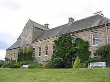
| |||
| Sawmill, Byres Of Murthly | 56°31′58″N 3°32′09″W | Category B | 11149 | Upload Photo | |||
| Murthly Asylum, Administrative Block | 56°31′54″N 3°27′51″W | Category C(S) | 11155 | Upload Photo | |||
| Nursery Cottage, Little Dunkeld | 56°33′44″N 3°35′06″W | Category C(S) | 11160 | .jpg.webp)
| |||
| Bheine Mhor, Perth Road Birnam | 56°33′27″N 3°34′31″W | Category C(S) | 11080 | Upload Photo | |||
| Craigielea And Dunsville, Gladstone Terrace, Birnam | 56°33′26″N 3°34′34″W | Category C(S) | 11084 | Upload Photo | |||
| Dunaird House, Torr Hill, Birnam | 56°33′30″N 3°34′24″W | Category B | 11094 | Upload Photo | |||
| Lagganallachy Grave Yard | 56°33′01″N 3°38′34″W | Category C(S) | 11107 | Upload Photo | |||
| Dalguise Railway Viaduct Over R. Tay | 56°36′45″N 3°38′21″W | Category A | 11117 | .jpg.webp)
| |||
| Inver Square | 56°33′41″N 3°36′08″W | Category B | 11133 | Upload Photo | |||
| Roman Bridge, Over Birnam Burn | 56°32′18″N 3°32′06″W | Category A | 11145 | .jpg.webp)
| |||
| Murthly Castle Policies, Fountain At East Lodge Fishing Hut | 56°32′16″N 3°29′24″W | Category C(S) | 50824 | Upload Photo | |||
| Robertson And Jamieson, Inver | 56°33′41″N 3°36′05″W | Category C(S) | 13736 | Upload Photo | |||
| Ossian's Hall of Mirrors, The Hermitage | 56°33′27″N 3°36′52″W | Category B | 11156 | 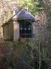
| |||
| Lagbeag, Little Dunkeld | 56°33′43″N 3°35′10″W | Category C(S) | 11161 | Upload Photo | |||
| Birnam Glen Tuck Shop And Lindisfarne, Birnam | 56°33′33″N 3°34′43″W | Category C(S) | 11085 | Upload Photo | |||
| Birchwood House, Torr Hill, Birnam | 56°33′25″N 3°34′21″W | Category B | 11095 | Upload Photo | |||
| Ballinloan Bridge Over Ballinloan Burn | 56°32′44″N 3°40′15″W | Category B | 11109 | Upload Photo | |||
| Aldmad Bridge Over R. Braan | 56°31′32″N 3°43′35″W | Category B | 11111 | Upload Photo | |||
| Balnamuir Cottage And Toll House | 56°38′40″N 3°41′06″W | Category C(S) | 11120 | Upload Photo | |||
| 1 Murthly Terrace (Mcmurray) Birnam | 56°33′32″N 3°34′37″W | Category C(S) | 11124 | Upload Photo | |||
| The Bungalow, Perth Road, Birnam | 56°33′29″N 3°34′35″W | Category C(S) | 11128 | Upload Photo | |||
| 2 Vacant Cottages East Of Inver Square | 56°33′41″N 3°36′05″W | Category C(S) | 11132 | Upload Photo | |||
| Todd And Chalmers, Inver | 56°33′40″N 3°36′06″W | Category C(S) | 11134 | Upload Photo | |||
| Inver Bridge Over River Braan | 56°33′37″N 3°35′59″W | Category B | 11136 | 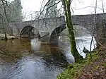
| |||
| Railway Bridge Over Hermitage Road, With Tunnel Entrance Above | 56°33′39″N 3°36′31″W | Category C(S) | 11138 | Upload Photo | |||
| Rohallion Lodge | 56°32′00″N 3°33′21″W | Category B | 11143 | Upload Photo | |||
| Murthly Castle Policies, East Lodge Fishing Hut | 56°32′16″N 3°29′23″W | Category C(S) | 50823 | Upload Photo | |||
| Eastern Terrace Block (Miss Isobella Lawrence And Miss S M Harvey's Property) Gladstone Terrace, Birnam | 56°33′25″N 3°34′31″W | Category C(S) | 13732 | Upload Photo | |||
| Chapel Of St Anthony The Eremite, Murthly | 56°32′36″N 3°30′43″W | Category A | 13460 | 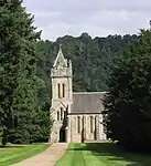
| |||
| Lantern Lodge, Murthly | 56°32′14″N 3°29′20″W | Category B | 11151 | Upload Photo | |||
| The Lodge, Birnam | 56°33′22″N 3°34′42″W | Category B | 11100 | Upload Photo | |||
| Craigmore | 56°33′20″N 3°34′34″W | Category B | 11102 | Upload Photo | |||
| Balmacneil Farm | 56°38′10″N 3°39′55″W | Category C(S) | 11119 | Upload Photo | |||
| Balnaguard Limekiln | 56°38′43″N 3°43′12″W | Category C(S) | 11122 | Upload Photo | |||
| Tower Buildings, Perth Road And Station Road, Birnam | 56°33′30″N 3°34′37″W | Category B | 11127 | .jpg.webp)
| |||
| Clunie, Inver | 56°33′39″N 3°36′05″W | Category C(S) | 11135 | Upload Photo | |||
| Rohallion, Buffalo Hut | 56°32′28″N 3°33′20″W | Category B | 50775 | Upload Photo | |||
| Upper Kinnaird | 56°37′36″N 3°39′41″W | Category B | 13735 | Upload Photo | |||
| Manse, Little Dunkeld | 56°33′45″N 3°35′14″W | Category C(S) | 11162 | Upload Photo | |||
| Parkview, Station Road, Birnam | 56°33′28″N 3°34′37″W | Category C(S) | 11081 | Upload Photo | |||
| Java, Birnam | 56°33′32″N 3°34′44″W | Category C(S) | 11087 | Upload Photo | |||
| Tayview, Oak Road, Birnam | 56°33′40″N 3°34′36″W | Category C(S) | 11092 | Upload Photo | |||
| Erigmore, Torr Hill, Birnam | 56°33′24″N 3°34′13″W | Category B | 11097 | Upload Photo | |||
| Oakbank, Birnam | 56°33′21″N 3°34′38″W | Category C(S) | 11101 | Upload Photo | |||
| Rumbling Bridge, Over Falls Of The Braan | 56°33′08″N 3°38′02″W | Category C(S) | 11106 | 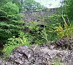
| |||
| Trochry Mill | 56°32′27″N 3°39′52″W | Category C(S) | 11110 | Upload Photo | |||
| Bridge At Glenfender Cottage Over Glenfender Burn | 56°31′14″N 3°45′38″W | Category C(S) | 11112 | Upload Photo | |||
| Macbeth Cottage, Perth Road, Birnam | 56°33′23″N 3°34′23″W | Category B | 11126 | Upload Photo | |||
| Birnam Hotel, Adjoining Gates And Annexe | 56°33′34″N 3°34′40″W | Category B | 11140 | 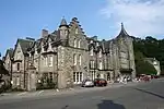
| |||
| St. Mary's Episcopal Church, Birnam | 56°33′30″N 3°34′33″W | Category B | 11141 | .jpg.webp)
| |||
| Murthly Signal Box | 56°31′43″N 3°27′47″W | Category B | 43644 | .jpg.webp)
| |||
| Bradyston, Murthly | 56°31′42″N 3°28′31″W | Category B | 11152 | Upload Photo | |||
| Ardoch, Farmhouse | 56°31′22″N 3°27′57″W | Category B | 11153 | Upload Photo | |||
| Ardoch, Steading | 56°31′22″N 3°27′55″W | Category C(S) | 11154 | Upload Photo | |||
| Little Dunkeld Parish Church | 56°33′44″N 3°34′56″W | Category B | 11157 | .jpg.webp)
| |||
| Little Dunkeld Churchyard | 56°33′44″N 3°34′56″W | Category C(S) | 11158 | .jpg.webp)
| |||
| Dunkeld Bridge Toll House, Little Dunkeld | 56°33′47″N 3°35′06″W | Category B | 11159 | .jpg.webp)
| |||
| Ladywell Cottages, Birnam | 56°33′33″N 3°34′44″W | Category C(S) | 11086 | .jpg.webp)
| |||
| Torwood House, St Mary's Road, Torr Hill, Birnam | 56°33′34″N 3°34′33″W | Category B | 11093 | Upload Photo | |||
| Ladyhill House And Outbuildings, St Mary's Road, Torr Hill, Birnam | 56°33′31″N 3°34′19″W | Category B | 11096 | Upload Photo | |||
| Drill Hall (Armoury House), Perth Road, Birnam | 56°33′28″N 3°34′34″W | Category B | 11129 | Upload Photo | |||
| Inver Railway Viaduct Over River Braan | 56°33′38″N 3°36′28″W | Category B | 11137 | Upload Photo | |||
| Rohallion, Cistern And Wellhead | 56°32′11″N 3°33′51″W | Category C(S) | 50776 | Upload Photo | |||
| Scott And Gow, Inver | 56°33′43″N 3°36′06″W | Category C(S) | 11164 | Upload Photo | |||
| Guthrie Villas Nos 1 And 2, Oak Road/St Mary's Road, Birnam | 56°33′33″N 3°34′36″W | Category C(S) | 11089 | Upload Photo | |||
| Birnam Bank House, Birnam | 56°33′23″N 3°34′45″W | Category C(S) | 11098 | Upload Photo | |||
| Birnam Bank Cottage, Birnam | 56°33′22″N 3°34′46″W | Category C(S) | 11099 | Upload Photo | |||
| Charleston, Dalguise | 56°36′29″N 3°38′37″W | Category B | 11114 | Upload Photo | |||
| Dalguise House, Stables | 56°36′36″N 3°38′43″W | Category B | 11116 | Upload Photo | |||
| Balnaguard Inn | 56°38′46″N 3°43′10″W | Category B | 11121 | Upload Photo | |||
| Cattenach, Inver | 56°33′42″N 3°36′07″W | Category C(S) | 11131 | Upload Photo |
Key
The scheme for classifying buildings in Scotland is:
- Category A: "buildings of national or international importance, either architectural or historic; or fine, little-altered examples of some particular period, style or building type."[1]
- Category B: "buildings of regional or more than local importance; or major examples of some particular period, style or building type, which may have been altered."[1]
- Category C: "buildings of local importance; lesser examples of any period, style, or building type, as originally constructed or moderately altered; and simple traditional buildings which group well with other listed buildings."[1]
In March 2016 there were 47,288 listed buildings in Scotland. Of these, 8% were Category A, and 50% were Category B, with the remaining 42% being Category C.[2]
Notes
- Sometimes known as OSGB36, the grid reference (where provided) is based on the British national grid reference system used by the Ordnance Survey.
• "Guide to National Grid". Ordnance Survey. Retrieved 12 December 2007.
• "Get-a-map". Ordnance Survey. Retrieved 17 December 2007. - Historic Environment Scotland assign a unique alphanumeric identifier to each designated site in Scotland, for listed buildings this always begins with "LB", for example "LB12345".
References
- All entries, addresses and coordinates are based on data from Historic Scotland. This data falls under the Open Government Licence
- "What is Listing?". Historic Environment Scotland. Retrieved 29 May 2018.
- Scotland's Historic Environment Audit 2016 (PDF). Historic Environment Scotland and the Built Environment Forum Scotland. pp. 15–16. Retrieved 29 May 2018.
This article is issued from Wikipedia. The text is licensed under Creative Commons - Attribution - Sharealike. Additional terms may apply for the media files.