Jallerange
Jallerange (French pronunciation: [ʒalʁɑ̃ʒ]) is a commune in the Doubs department in the Bourgogne-Franche-Comté region in eastern France.
Jallerange | |
|---|---|
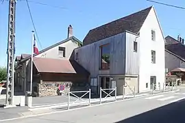 The town hall in Jallerange | |
 Coat of arms | |
Location of Jallerange | |
 Jallerange  Jallerange | |
| Coordinates: 47°15′18″N 5°43′03″E | |
| Country | France |
| Region | Bourgogne-Franche-Comté |
| Department | Doubs |
| Arrondissement | Besançon |
| Canton | Saint-Vit |
| Government | |
| • Mayor (2020–2026) | Gilles Pinassaud[1] |
| Area 1 | 5.41 km2 (2.09 sq mi) |
| Population | 267 |
| • Density | 49/km2 (130/sq mi) |
| Time zone | UTC+01:00 (CET) |
| • Summer (DST) | UTC+02:00 (CEST) |
| INSEE/Postal code | 25317 /25170 |
| Elevation | 198–320 m (650–1,050 ft) |
| 1 French Land Register data, which excludes lakes, ponds, glaciers > 1 km2 (0.386 sq mi or 247 acres) and river estuaries. | |
Geography
The commune is situated 26 km (16 mi) west of Besançon.
History
An imposing Roman villa was discovered in 1771 by Claude Seguin, Seigneur de Jallerange. He created a magnificent garden designed by André Le Nôtre, which has been maintained in the same style for over 200 years.
Population
| Year | Pop. | ±% |
|---|---|---|
| 1962 | 151 | — |
| 1968 | 184 | +21.9% |
| 1975 | 170 | −7.6% |
| 1982 | 155 | −8.8% |
| 1990 | 145 | −6.5% |
| 1999 | 169 | +16.6% |
| 2008 | 204 | +20.7% |
| 2012 | 186 | −8.8% |
The inhabitants of the commune are called Joutereys.
See also
References
- "Répertoire national des élus: les maires" (in French). data.gouv.fr, Plateforme ouverte des données publiques françaises. 13 September 2022.
- "Populations légales 2020". The National Institute of Statistics and Economic Studies. 29 December 2022.
External links
Wikimedia Commons has media related to Jallerange.
This article is issued from Wikipedia. The text is licensed under Creative Commons - Attribution - Sharealike. Additional terms may apply for the media files.