Le Luhier
Le Luhier (French pronunciation: [lə lyje]) is a commune in the Doubs department in the Bourgogne-Franche-Comté region in eastern France.
Le Luhier | |
|---|---|
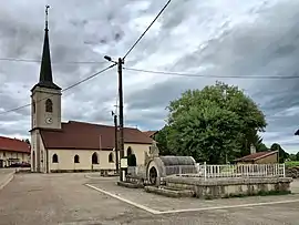 The fountain and church in Le Luhier | |
Location of Le Luhier | |
 Le Luhier  Le Luhier | |
| Coordinates: 47°10′09″N 6°39′36″E | |
| Country | France |
| Region | Bourgogne-Franche-Comté |
| Department | Doubs |
| Arrondissement | Pontarlier |
| Canton | Morteau |
| Intercommunality | Plateau du Russey |
| Government | |
| • Mayor (2020–2026) | Eric Humbert[1] |
| Area 1 | 5.21 km2 (2.01 sq mi) |
| Population | 239 |
| • Density | 46/km2 (120/sq mi) |
| Time zone | UTC+01:00 (CET) |
| • Summer (DST) | UTC+02:00 (CEST) |
| INSEE/Postal code | 25351 /25210 |
| Elevation | 790–1,050 m (2,590–3,440 ft) |
| 1 French Land Register data, which excludes lakes, ponds, glaciers > 1 km2 (0.386 sq mi or 247 acres) and river estuaries. | |
Geography
The commune is located 9 km (5.6 mi) east of Le Russey on the road from Maîche to Besançon.
Population
| Year | Pop. | ±% |
|---|---|---|
| 1962 | 133 | — |
| 1968 | 162 | +21.8% |
| 1975 | 137 | −15.4% |
| 1982 | 148 | +8.0% |
| 1990 | 160 | +8.1% |
| 1999 | 146 | −8.8% |
| 2008 | 187 | +28.1% |
| 2012 | 199 | +6.4% |
See also
References
- "Répertoire national des élus: les maires". data.gouv.fr, Plateforme ouverte des données publiques françaises (in French). 2 December 2020.
- "Populations légales 2020". The National Institute of Statistics and Economic Studies. 29 December 2022.
External links
Wikimedia Commons has media related to Le Luhier.
This article is issued from Wikipedia. The text is licensed under Creative Commons - Attribution - Sharealike. Additional terms may apply for the media files.