Larnod
Larnod (French pronunciation: [laʁno]) is a commune in the Doubs department in the Bourgogne-Franche-Comté region in eastern France.
Larnod | |
|---|---|
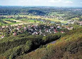 A general view of Larnod | |
Location of Larnod | |
 Larnod  Larnod | |
| Coordinates: 47°11′11″N 5°58′22″E | |
| Country | France |
| Region | Bourgogne-Franche-Comté |
| Department | Doubs |
| Arrondissement | Besançon |
| Canton | Besançon-6 |
| Intercommunality | Grand Besançon Métropole |
| Government | |
| • Mayor (2020–2026) | Hugues Trudet[1] |
| Area 1 | 4.05 km2 (1.56 sq mi) |
| Population | 796 |
| • Density | 200/km2 (510/sq mi) |
| Time zone | UTC+01:00 (CET) |
| • Summer (DST) | UTC+02:00 (CEST) |
| INSEE/Postal code | 25328 /25720 |
| Elevation | 296–470 m (971–1,542 ft) (avg. 380 m or 1,250 ft) |
| 1 French Land Register data, which excludes lakes, ponds, glaciers > 1 km2 (0.386 sq mi or 247 acres) and river estuaries. | |
Geography
Larnod is situated on a hill over the valley of the river Doubs. It lies on departmental highway 308 7 km (4.3 mi) northeast of Boussières.
Population
| Year | Pop. | ±% p.a. |
|---|---|---|
| 1968 | 216 | — |
| 1975 | 306 | +5.10% |
| 1982 | 514 | +7.69% |
| 1990 | 649 | +2.96% |
| 1999 | 647 | −0.03% |
| 2007 | 590 | −1.15% |
| 2012 | 695 | +3.33% |
| 2017 | 773 | +2.15% |
| Source: INSEE[3] | ||
The inhabitants of the commune are called Larnodiens.
See also
References
- "Répertoire national des élus: les maires". data.gouv.fr, Plateforme ouverte des données publiques françaises (in French). 9 August 2021.
- "Populations légales 2020". The National Institute of Statistics and Economic Studies. 29 December 2022.
- Population en historique depuis 1968, INSEE
External links
Wikimedia Commons has media related to Larnod.
This article is issued from Wikipedia. The text is licensed under Creative Commons - Attribution - Sharealike. Additional terms may apply for the media files.