Le Moutherot
Le Moutherot (French pronunciation: [lə mutʁo]) is a commune in the Doubs department in the Bourgogne-Franche-Comté region in eastern France.
Le Moutherot | |
|---|---|
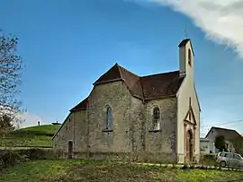 The chapel in Le Moutherot | |
 Coat of arms | |
Location of Le Moutherot | |
 Le Moutherot  Le Moutherot | |
| Coordinates: 47°14′38″N 5°43′59″E | |
| Country | France |
| Region | Bourgogne-Franche-Comté |
| Department | Doubs |
| Arrondissement | Besançon |
| Canton | Saint-Vit |
| Government | |
| • Mayor (2020–2026) | Alain Theurel[1] |
| Area 1 | 1.3 km2 (0.5 sq mi) |
| Population | 126 |
| • Density | 97/km2 (250/sq mi) |
| Time zone | UTC+01:00 (CET) |
| • Summer (DST) | UTC+02:00 (CEST) |
| INSEE/Postal code | 25414 /25170 |
| Elevation | 239–324 m (784–1,063 ft) |
| 1 French Land Register data, which excludes lakes, ponds, glaciers > 1 km2 (0.386 sq mi or 247 acres) and river estuaries. | |
Geography
The commune lies 25 km (16 mi) from Besançon, Dole, and Gray between the rivers Ognon and Doubs.
On a top of a hill, the village offers a view on fields, forests. In bright weather Mont Blanc, the Mount Poupet, and the "Ballon of Alsace" can be seen.
Population
| Year | Pop. | ±% |
|---|---|---|
| 1962 | 20 | — |
| 1968 | 23 | +15.0% |
| 1975 | 30 | +30.4% |
| 1982 | 37 | +23.3% |
| 1990 | 61 | +64.9% |
| 1999 | 78 | +27.9% |
| 2008 | 103 | +32.1% |
| 2012 | 131 | +27.2% |
See also
References
- "Répertoire national des élus: les maires". data.gouv.fr, Plateforme ouverte des données publiques françaises (in French). 9 August 2021.
- "Populations légales 2020". The National Institute of Statistics and Economic Studies. 29 December 2022.
External links
Wikimedia Commons has media related to Le Moutherot.
This article is issued from Wikipedia. The text is licensed under Creative Commons - Attribution - Sharealike. Additional terms may apply for the media files.