Lougres
Lougres (French pronunciation: [luɡʁ]) is a commune in the Doubs department in the Bourgogne-Franche-Comté region in eastern France.
Lougres | |
|---|---|
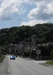 The Lutheran church in Lougres | |
 Coat of arms | |
Location of Lougres | |
 Lougres  Lougres | |
| Coordinates: 47°28′21″N 6°41′15″E | |
| Country | France |
| Region | Bourgogne-Franche-Comté |
| Department | Doubs |
| Arrondissement | Montbéliard |
| Canton | Bavans |
| Intercommunality | Pays de Montbéliard Agglomération |
| Government | |
| • Mayor (2020–2026) | Patrick Froehly[1] |
| Area 1 | 5.97 km2 (2.31 sq mi) |
| Population | 730 |
| • Density | 120/km2 (320/sq mi) |
| Time zone | UTC+01:00 (CET) |
| • Summer (DST) | UTC+02:00 (CEST) |
| INSEE/Postal code | 25350 /25260 |
| Elevation | 297–440 m (974–1,444 ft) |
| 1 French Land Register data, which excludes lakes, ponds, glaciers > 1 km2 (0.386 sq mi or 247 acres) and river estuaries. | |
Geography
Lougres lies 14 km (8.7 mi) southwest of Montbéliard.
The commune takes its name from the stream that runs through it, from its source to the river Doubs.
Population
| Year | Pop. | ±% |
|---|---|---|
| 1962 | 515 | — |
| 1968 | 621 | +20.6% |
| 1975 | 713 | +14.8% |
| 1982 | 733 | +2.8% |
| 1990 | 722 | −1.5% |
| 1999 | 683 | −5.4% |
| 2008 | 756 | +10.7% |
| 2128 | 785 | +3.8% |
See also
References
- "Répertoire national des élus: les maires". data.gouv.fr, Plateforme ouverte des données publiques françaises (in French). 2 December 2020.
- "Populations légales 2020". The National Institute of Statistics and Economic Studies. 29 December 2022.
External links
Wikimedia Commons has media related to Lougres.
This article is issued from Wikipedia. The text is licensed under Creative Commons - Attribution - Sharealike. Additional terms may apply for the media files.