Les Fins
Les Fins (French pronunciation: [le fɛ̃]) is a commune in the Doubs department in the Bourgogne-Franche-Comté region in eastern France.
Les Fins | |
|---|---|
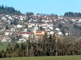 A general view of Les Fins | |
 Coat of arms | |
Location of Les Fins | |
 Les Fins  Les Fins | |
| Coordinates: 47°04′54″N 6°37′45″E | |
| Country | France |
| Region | Bourgogne-Franche-Comté |
| Department | Doubs |
| Arrondissement | Pontarlier |
| Canton | Morteau |
| Intercommunality | Val de Morteau |
| Government | |
| • Mayor (2020–2026) | Elisabeth Redoutey[1] |
| Area 1 | 25.39 km2 (9.80 sq mi) |
| Population | 3,157 |
| • Density | 120/km2 (320/sq mi) |
| Time zone | UTC+01:00 (CET) |
| • Summer (DST) | UTC+02:00 (CEST) |
| INSEE/Postal code | 25240 /25500 |
| Elevation | 750–1,154 m (2,461–3,786 ft) |
| 1 French Land Register data, which excludes lakes, ponds, glaciers > 1 km2 (0.386 sq mi or 247 acres) and river estuaries. | |
Population
|
| |||||||||||||||||||||||||||||||||||||||||||||||||||||||||||||||||||||
| Source: EHESS[3] and INSEE (1968-2017)[4] | ||||||||||||||||||||||||||||||||||||||||||||||||||||||||||||||||||||||
See also
References
- "Répertoire national des élus: les maires" (in French). data.gouv.fr, Plateforme ouverte des données publiques françaises. 13 September 2022.
- "Populations légales 2020". The National Institute of Statistics and Economic Studies. 29 December 2022.
- Des villages de Cassini aux communes d'aujourd'hui: Commune data sheet Les Fins, EHESS (in French).
- Population en historique depuis 1968, INSEE
Wikimedia Commons has media related to Les Fins.
This article is issued from Wikipedia. The text is licensed under Creative Commons - Attribution - Sharealike. Additional terms may apply for the media files.